Demography
Population (2011)
516,075
Census 2011
Area
2144.9 Ha
21.45 sq.km
Gross Density
241 PPH
Persons per Hectare
Wards/Villages
10
Within BBMP
Western BMA. Peenya Industrial Area (Machine Tools hub), Doddanna Industrial Area. 71.1% decadal growth. Residential density 698 pph. 37.64% water, 21.83% sewage. 22 slums (9.14% population). Vrushabhavathi River; 7 lakes highly polluted.
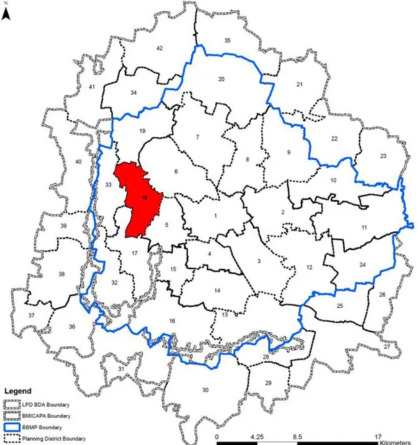
Gross Density: 240.6 pph Peenya – Nagarbhavi Planning District (PD 18) is located in the western parts of BMA between Tumukuru Road and Mysore Road. It characterised by presence of large Industrial Areas such as Peenya, dense residential areas, commercial activities along the roads, educational institutes and Vrishabhavatii River. The Revised Master Plan 2031 proposes to consolidate the development in the area and streamline transportation and infrastructure and increase public transport share in this Planning District.
1. The Peenya - Nagarbhavi PD is spread across the either side of the western reach of the Outer Ring Road and it comprises of 10 BBMP wards – namely Kamakshipalya (101), Kaveripura (103), Shakthiganapathi Nagar (74), Shankaramata (75), Vrushabhavathi (102), Koigepalya (73), Laggere (69), Peenya Industrial Area (41), Rajagopala Nagar (70) and Moodalapalya (127).
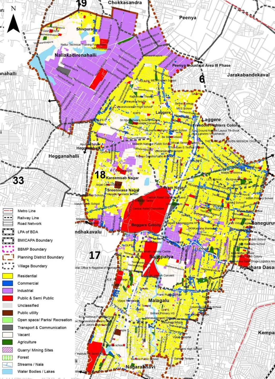
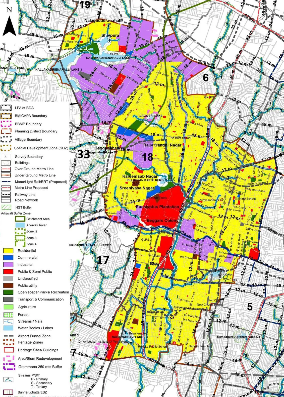
The Existing Land Use Map and Proposed Land Use Map for this PD are in the Planning District Report (PDF). Open the document and go to this PD’s section; use the List of Figures to find “PD 18 Existing Land Use Map” and “PD 18 Proposed Land Use Map”.
| Land use Category | Area (in Ha) | Percentage to Total Area (%) |
|---|---|---|
| Residential | 747.07 | 34.83 |
| Commercial | 103.38 | 4.82 |
| Industrial | 384.79 | 17.94 |
| Quarry/ Mining Sites | 0.00 | 0.00 |
| Public & Semi Public | 150.79 | 7.03 |
| Unclassified | 0.00 | 0.00 |
| Public Utility | 0.00 | 0.00 |
| Parks & Open Spaces | 29.17 | 1.36 |
| Transport & Communication | 312.84 | 14.59 |
| Vacant | 353.05 | 16.46 |
| Agriculture | 0.00 | 0.00 |
| Forest | 0.00 | 0.00 |
| Streams | 0.00 | 0.00 |
| Water Bodies | 35.18 | 1.64 |
| NGT Buffer | 0.00 | 0.00 |
| Other | 21.66 | 1.01 |
| Total | 2144.90 | 100.00 |
| Land use Category | Area (in Ha) | Percentage To Total Developable Area (%) |
|---|---|---|
| Residential | 971.70 | 45.30 |
| Commercial | 52.12 | 2.43 |
| Industrial | 329.77 | 15.37 |
| Quarry/ Mining Sites | 0.00 | 0.00 |
| Public & Semi Public | 133.84 | 6.24 |
| Unclassified | 0.00 | 0.00 |
| Public Utility | 0.00 | 0.00 |
| Parks & Open Spaces | 39.25 | 1.83 |
| Transport & Communication | 335.68 | 15.65 |
| Vacant | 0.00 | 0.00 |
| Agriculture | 0.00 | 0.00 |
| Forest | 0.00 | 0.00 |
| Streams | 0.00 | 0.00 |
| Water Bodies | 35.18 | 1.64 |
| NGT Buffer | 200.12 | 9.33 |
| Other | 21.24 | 0.99 |
| Total Developable Area | 2118.90 | , |
Total PD Area 2144.90 Ha. Source: Revised Master Plan 2031 (Draft) Volume-4.
Road Development Plan, Public Transport System, Multimodal Interchange Stations, Parks and Open Spaces, Protection and Rejuvenation of Lakes and Streams, Area Redevelopment, Heritage Area Protection and Conservation, Physical Infrastructure, Disaster Mitigation.