Demography
Population (2011)
249,522
Census 2011
Area
2423.7 Ha
24.24 sq.km
Gross Density
103 PPH
Persons per Hectare
Wards/Villages
5
Within BBMP
South West BMA. Bangalore University, ISEC, National Law School. Low rise high density residential (Channappa layout, Railway layout, BEML layout). 102% decadal growth. 48.1% water, 27.2% sewage. 15 slums (12.63% population).
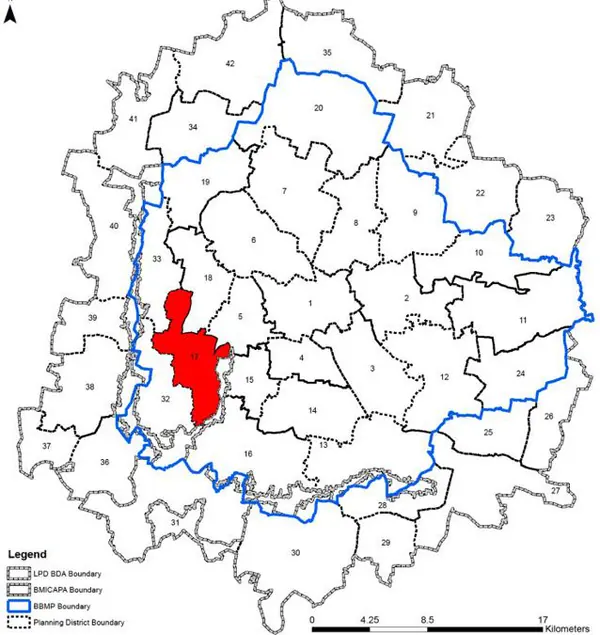
Wards (full) 2 Wards (part) The Nayanadahalli (PD number 17) is located in South Western part of BMA and falls within the BBMP limits. It is bounded by the NICE Expresssway at its South side. This PD is predominantly Public Semi- Public and Residential areas. Tha Revised Master Plan 2031 proposes densificaton of the residential areas in a regulated manner with better acesss to parks and open spaces.
1. The Nayanadahalli PD comprises of 5 wards in total; with 3 full wards of Nagarabhavi (128), Jnanabharathi Ward (129), Nayandanahalli (131), and 4 part wards of Deepanjali Nagar (158) and Rajarajeshwari Nagar (160). Some major landmarks are in this PD are Bangalore University and Rajarajeshwari Arch.
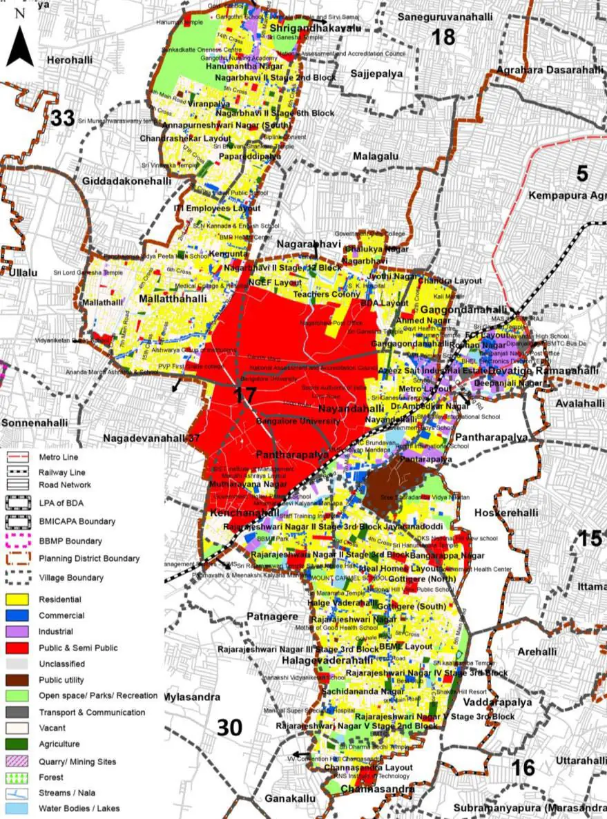
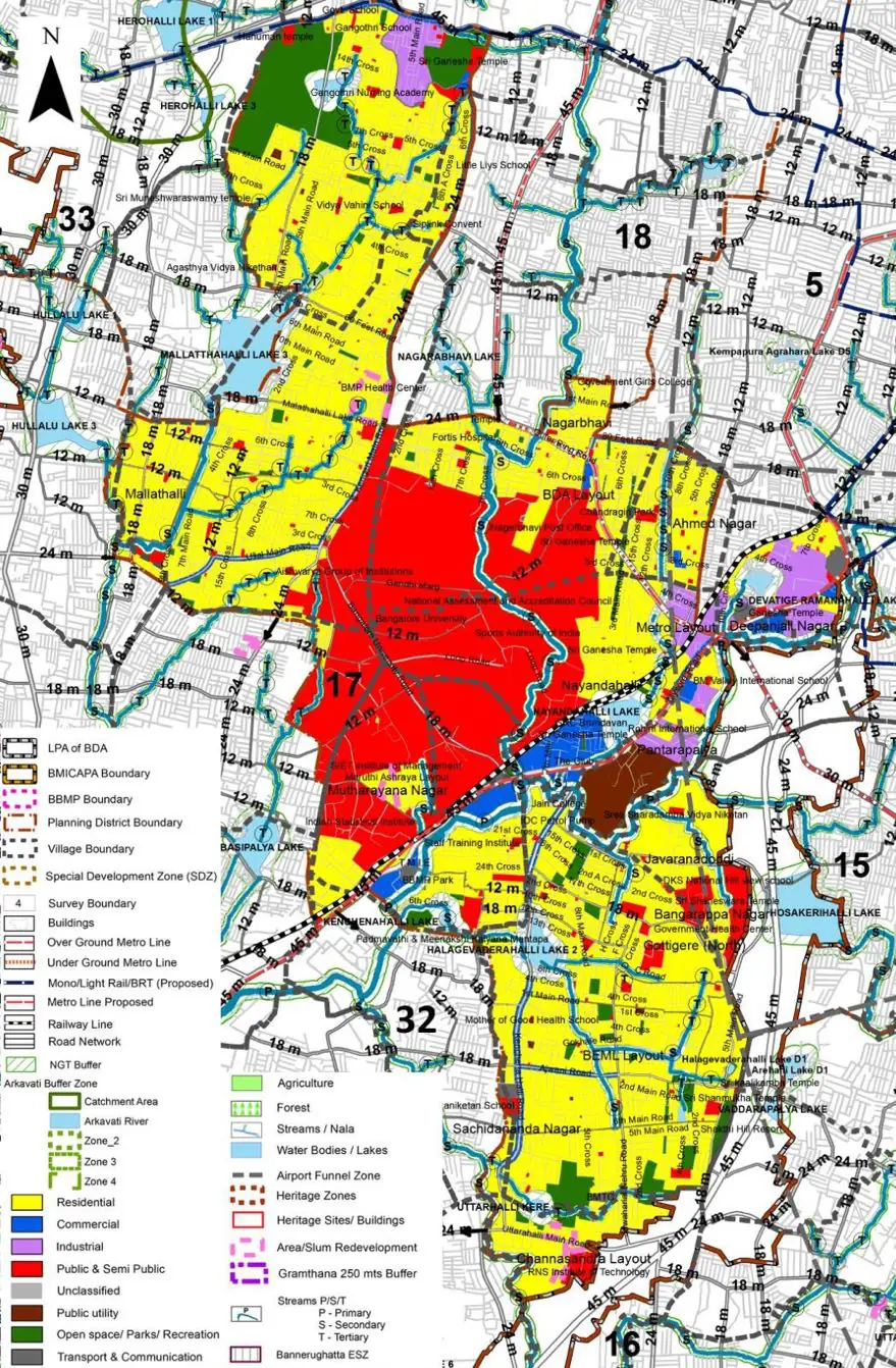
The Existing Land Use Map and Proposed Land Use Map for this PD are in the Planning District Report (PDF). Open the document and go to this PD’s section; use the List of Figures to find “PD 17 Existing Land Use Map” and “PD 17 Proposed Land Use Map”.
| Land use Category | Area (in Ha) | Percentage to Total Area (%) |
|---|---|---|
| Residential | 596.19 | 24.60 |
| Commercial | 88.47 | 3.65 |
| Industrial | 72.47 | 2.99 |
| Quarry/ Mining Sites | 0.00 | 0.00 |
| Public & Semi Public | 545.25 | 22.50 |
| Unclassified | 0.00 | 0.00 |
| Public Utility | 0.00 | 0.00 |
| Parks & Open Spaces | 40.96 | 1.69 |
| Transport & Communication | 267.58 | 11.04 |
| Vacant | 730.59 | 30.14 |
| Agriculture | 0.00 | 0.00 |
| Forest | 0.00 | 0.00 |
| Streams | 0.00 | 0.00 |
| Water Bodies | 16.24 | 0.67 |
| NGT Buffer | 0.00 | 0.00 |
| Other | 26.93 | 1.11 |
| Total | 2423.71 | 100.00 |
| Land use Category | Area (in Ha) | Percentage To Total Developable Area (%) |
|---|---|---|
| Residential | 1032.95 | 42.62 |
| Commercial | 54.01 | 2.23 |
| Industrial | 60.11 | 2.48 |
| Quarry/ Mining Sites | 0.00 | 0.00 |
| Public & Semi Public | 504.86 | 20.83 |
| Unclassified | 0.00 | 0.00 |
| Public Utility | 0.00 | 0.00 |
| Parks & Open Spaces | 113.91 | 4.70 |
| Transport & Communication | 307.33 | 12.68 |
| Vacant | 0.00 | 0.00 |
| Agriculture | 0.00 | 0.00 |
| Forest | 0.00 | 0.00 |
| Streams | 0.00 | 0.00 |
| Water Bodies | 15.75 | 0.65 |
| NGT Buffer | 277.96 | 11.47 |
| Other | 26.66 | 1.10 |
| Total Developable Area | 2393.54 | , |
Total PD Area 2423.71 Ha. Source: Revised Master Plan 2031 (Draft) Volume-4.
Road Development Plan, Public Transport System, Multimodal Interchange Stations, Parks and Open Spaces, Protection and Rejuvenation of Lakes and Streams, Area Redevelopment, Heritage Area Protection and Conservation, Physical Infrastructure, Disaster Mitigation.