Demography
Population (2011)
226,985
Census 2011
Area
5429.4 Ha
54.29 sq.km
Gross Density
42 PPH
Persons per Hectare
Wards/Villages
5
Within BBMP
Northern BMA. Yelahanka New Town, part of Yelahanka Airbase. NH-7 Bellary Road, proposed PRR. 97.49% decadal growth. 14.76% water, 17.5% sewage. Rail-wheel Factory, pharma, apparel, plastic industries.
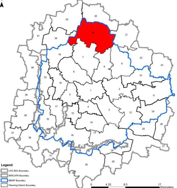
Gross Density: 42.8 pph Planning District 20 is located in the northern side of the BMA planning area and is between Hessarghata Main Road and Hennur Main Road. The PD is spatially structured around the NH 7(Bellary road) and SH9 (Yelahanka main road). The PD is predominantly characterised by large institutional campuses, system of lakes and well planned residential layouts. Also there are large tracts of vacant land (28.91%) and Agricultural land (21.12%). The Revised Master Plan 2031 proposes further densification and integration with transit system .
1. The Yelahanka PD extent admeasures 5429.44 ha and comprises of 5 wards namely Kempegowda (1), Chowdeshwari (2), Atur (3), Yelahanka Satellite (4) and Jakkur (5).
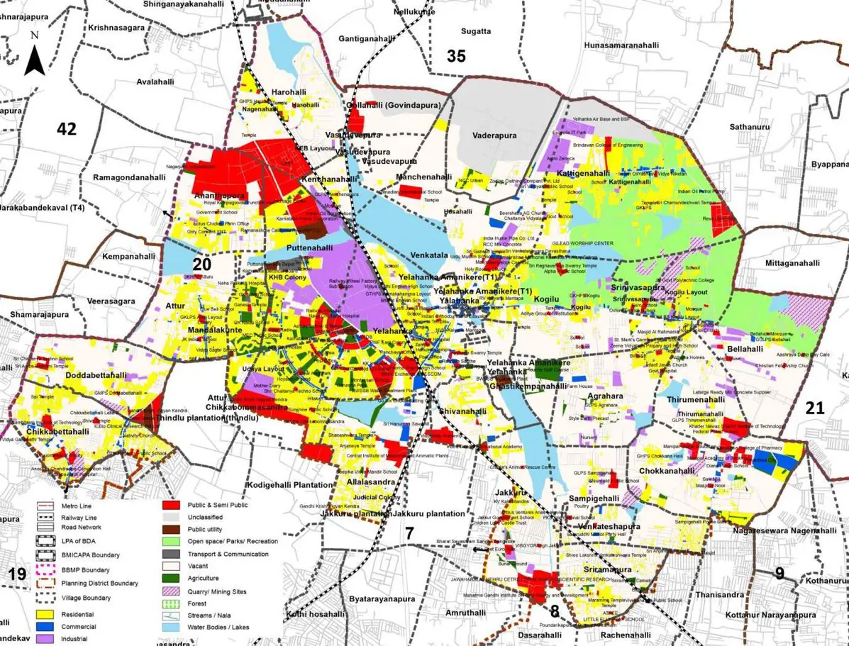
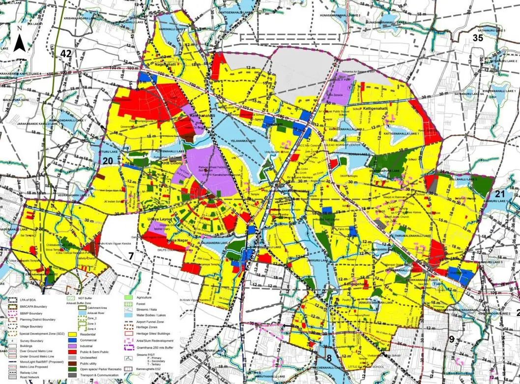
The Existing Land Use Map and Proposed Land Use Map for this PD are in the Planning District Report (PDF). Open the document and go to this PD’s section; use the List of Figures to find “PD 20 Existing Land Use Map” and “PD 20 Proposed Land Use Map”.
| Land use Category | Area (in Ha) | Percentage to Total Area (%) |
|---|---|---|
| Residential | 872.41 | 16.07 |
| Commercial | 88.50 | 1.63 |
| Industrial | 221.52 | 4.08 |
| Quarry/ Mining Sites | 0.00 | 0.00 |
| Public & Semi Public | 334.80 | 6.17 |
| Unclassified | 0.00 | 0.00 |
| Public Utility | 0.00 | 0.00 |
| Parks & Open Spaces | 81.34 | 1.50 |
| Transport & Communication | 393.63 | 7.25 |
| Vacant | 2714.83 | 50.00 |
| Agriculture | 0.00 | 0.00 |
| Forest | 0.00 | 0.00 |
| Streams | 0.00 | 0.00 |
| Water Bodies | 358.89 | 6.61 |
| NGT Buffer | 0.00 | 0.00 |
| Other | 249.52 | 4.60 |
| Total | 5429.44 | 100.00 |
| Land use Category | Area (in Ha) | Percentage To Total Developable Area (%) |
|---|---|---|
| Residential | 2794.40 | 51.47 |
| Commercial | 99.90 | 1.84 |
| Industrial | 172.66 | 3.18 |
| Quarry/ Mining Sites | 0.00 | 0.00 |
| Public & Semi Public | 347.83 | 6.41 |
| Unclassified | 0.00 | 0.00 |
| Public Utility | 0.00 | 0.00 |
| Parks & Open Spaces | 228.92 | 4.22 |
| Transport & Communication | 664.20 | 12.23 |
| Vacant | 0.00 | 0.00 |
| Agriculture | 0.00 | 0.00 |
| Forest | 0.00 | 0.00 |
| Streams | 0.00 | 0.00 |
| Water Bodies | 338.80 | 6.24 |
| NGT Buffer | 504.59 | 9.29 |
| Other | 247.34 | 4.56 |
| Total Developable Area | 5398.64 | , |
Total PD Area 5429.44 Ha. Source: Revised Master Plan 2031 (Draft) Volume-4.
Road Development Plan, Public Transport System, Multimodal Interchange Stations, Parks and Open Spaces, Protection and Rejuvenation of Lakes and Streams, Area Redevelopment, Heritage Area Protection and Conservation, Physical Infrastructure, Disaster Mitigation.