Demography
Population (2011)
28,594
Census 2011
Area
3132.2 Ha
31.32 sq.km
Gross Density
9 PPH
Persons per Hectare
Wards/Villages
12
Outside BBMP
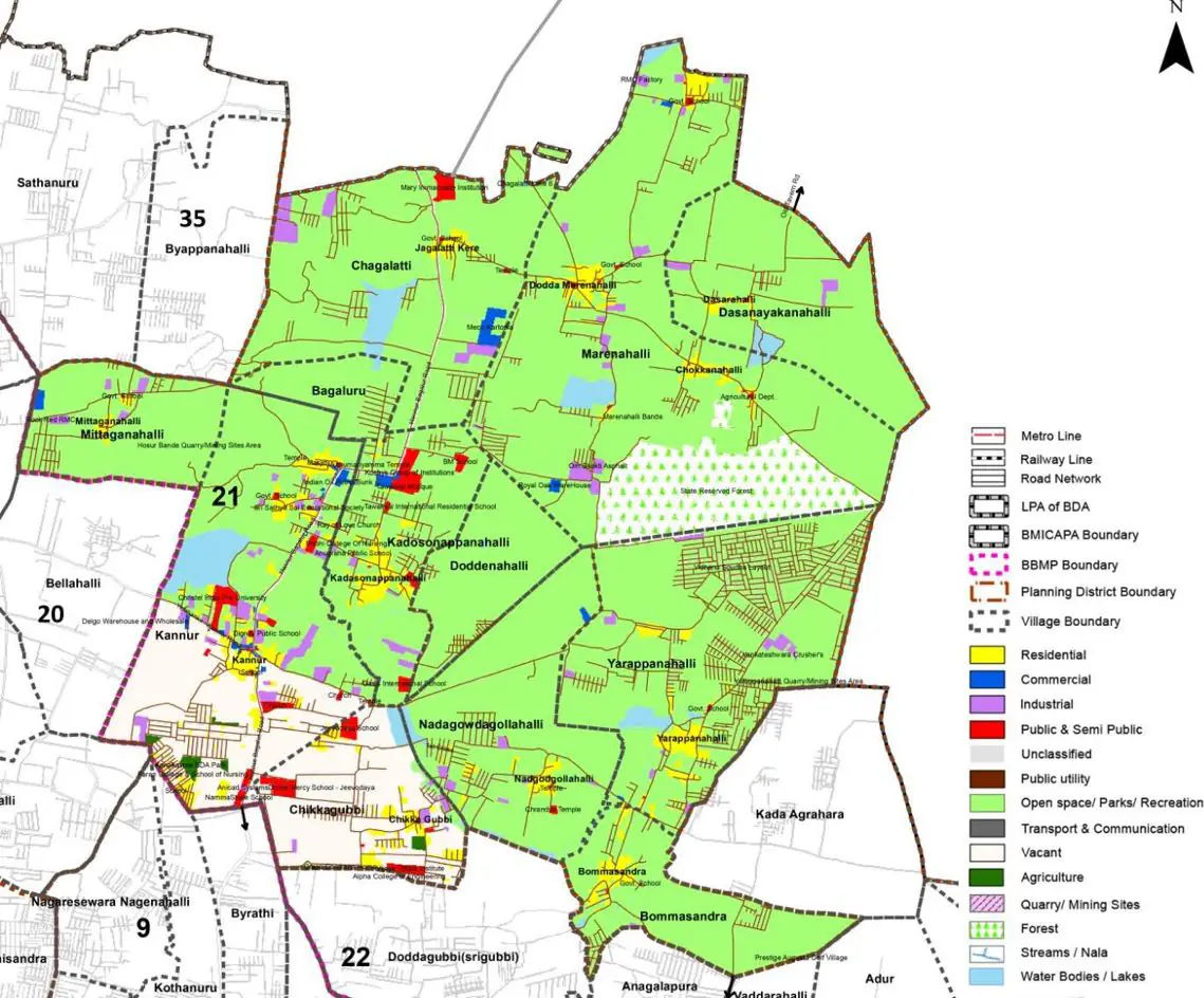
North-East BMA between Hennur and Kadda Agrahara. Predominantly agricultural (55.61%). Hosur Bande live granite quarry, cement block factories. 47.3% decadal growth. No metered water/sewage; tanker dependent. 17 schools.
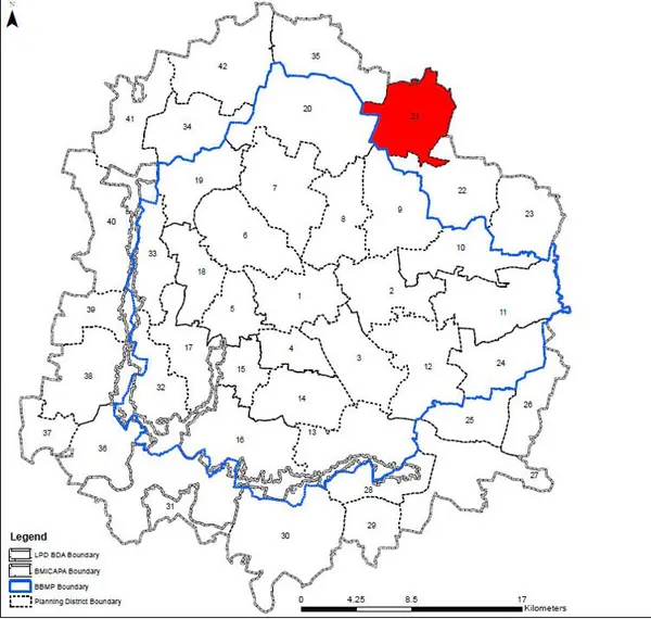
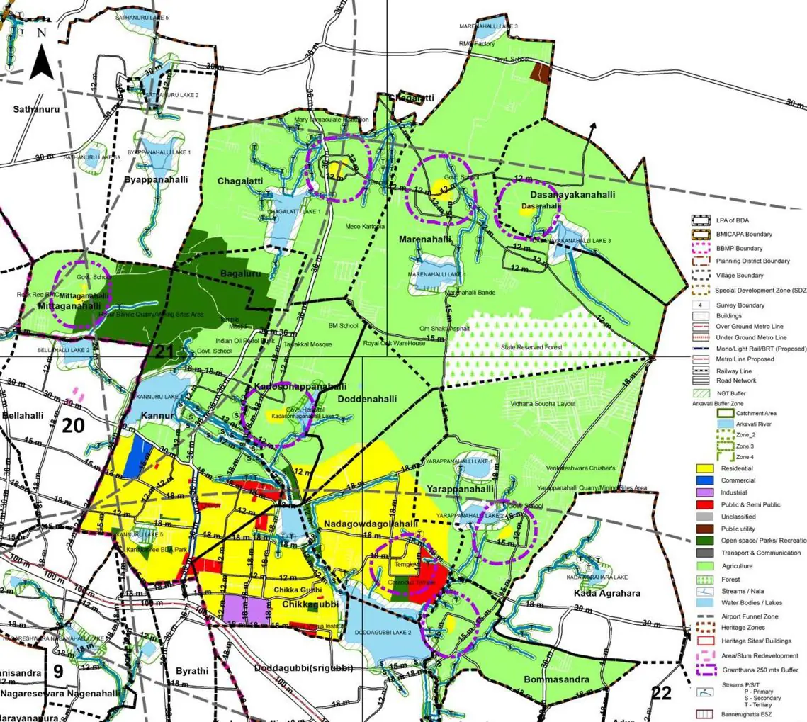
Gramathanas in PD: 12 Marenahalli Planning District (PD 21) is located in the North-Eastern side of BMA between Hennur Main Road and Kadda Agrahara Main road. PD is predominantly agricultural with large quarry and mining sites. It shares its boundary with BIAPPA and Hoskote Planning Authority. The Revised Master Plan 2031 proposes limited growth along Peripheral Ring Road while retaining the Agriculture Zone and Development of Regional Park.
1. The Marenahalli – Kannur PD extent admeasures 3132.2 Ha and falls within Bidarahalli and Jalla Hoblis and comprises of 12 villages namely Marenahalli, Bagalaru, Chagalai, Dasanayakanahalli, Mitaganahalli, Kannuru, Kadasonnappanahalli, Doddenahalli, Yarappanahalli, Nadagavadagollahalli, Chikkagubbi and Bommasandra.
The Existing Land Use Map and Proposed Land Use Map for this PD are in the Planning District Report (PDF). Open the document and go to this PD’s section; use the List of Figures to find “PD 21 Existing Land Use Map” and “PD 21 Proposed Land Use Map”.
| Land use Category | Area (in Ha) | Percentage to Total Area (%) |
|---|---|---|
| Residential | 113.70 | 3.63 |
| Commercial | 12.53 | 0.40 |
| Industrial | 59.83 | 1.91 |
| Quarry/ Mining Sites | 0.00 | 0.00 |
| Public & Semi Public | 0.00 | 0.00 |
| Unclassified | 0.00 | 0.00 |
| Public Utility | 0.00 | 0.00 |
| Parks & Open Spaces | 5.01 | 0.16 |
| Transport & Communication | 110.04 | 3.51 |
| Vacant | 629.26 | 20.09 |
| Agriculture | 1742.00 | 55.62 |
| Forest | 132.18 | 4.22 |
| Streams | 0.00 | 0.00 |
| Water Bodies | 68.91 | 2.20 |
| NGT Buffer | 0.00 | 0.00 |
| Other | 223.33 | 7.13 |
| Total | 3132.20 | 100.00 |
| Land use Category | Area (in Ha) | Percentage To Total Developable Area (%) |
|---|---|---|
| Residential | 2280.82 | 72.82 |
| Commercial | 72.67 | 2.32 |
| Industrial | 43.85 | 1.40 |
| Quarry/ Mining Sites | 0.00 | 0.00 |
| Public & Semi Public | 80.50 | 2.57 |
| Unclassified | 0.00 | 0.00 |
| Public Utility | 0.00 | 0.00 |
| Parks & Open Spaces | 47.61 | 1.52 |
| Transport & Communication | 323.66 | 10.33 |
| Vacant | 0.00 | 0.00 |
| Agriculture | 0.00 | 0.00 |
| Forest | 0.00 | 0.00 |
| Streams | 0.00 | 0.00 |
| Water Bodies | 37.27 | 1.19 |
| NGT Buffer | 243.06 | 7.76 |
| Other | 3.76 | 0.12 |
| Total Developable Area | 3133.20 | , |
Total PD Area 3132.20 Ha. Source: Revised Master Plan 2031 (Draft) Volume-4.
Road Development Plan, Public Transport System, Multimodal Interchange Stations, Parks and Open Spaces, Protection and Rejuvenation of Lakes and Streams, Area Redevelopment, Heritage Area Protection and Conservation, Physical Infrastructure, Disaster Mitigation.