Demography
Population (2011)
21,300
Census 2011
Area
1938.9 Ha
19.39 sq.km
Gross Density
11 PPH
Persons per Hectare
Wards/Villages
9
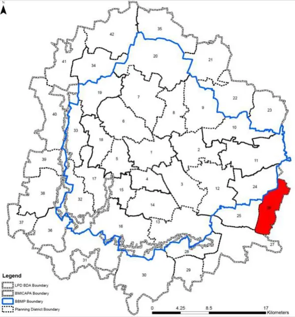
Outside BBMP
Outside BBMP, south-east. 53.7% decadal growth. 77% agriculture. Dommasandra largest village. Sarjapura Road, SH35, Dommasandra–Channasandra Road. 17 schools; 12 lakes (part/full).
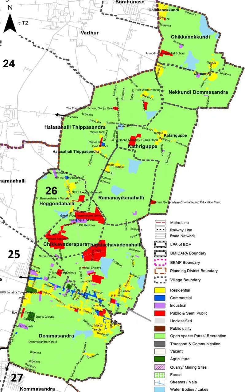
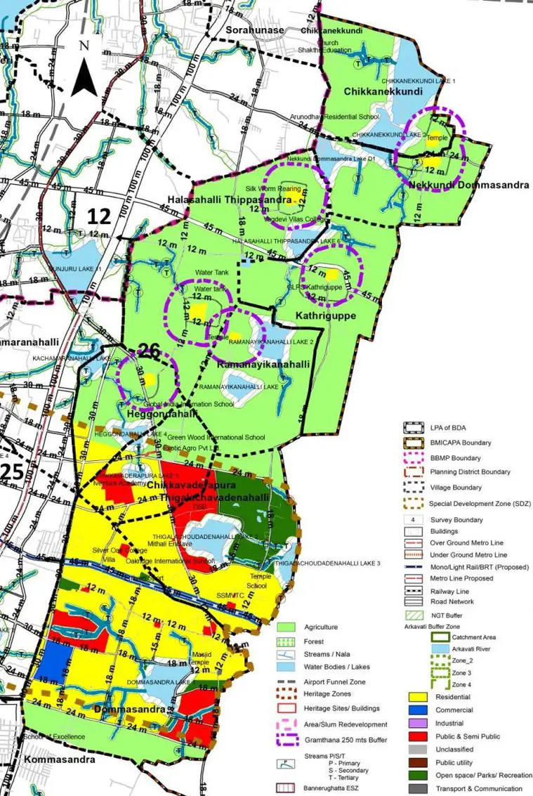
1. Planning District comprises of nine villages falling under three different Gram Panchayats, namely Dommasandra GP, Yamare GP and Neriga GP. The nine Villages are a) Dommasandra (Dommasandra GP), Thigalachavadadenahalli (Yamare GP), Heggondahalli, Chikkavaderapura, , Ramanayikanahalli, Halasahalli Thippasandra, Nekkundi Dommasandra, Katheriguppe and Chikkanekkundi (all in Neriga GP).
2. The Sarjapura Road, State Highway 35, Dommasandra – Channasandra Road, Huskuru – Dommosandra Road, Gunjur – Magalur Road, Halasahalli Cross Road/ Nekkundi Dommasandra Road defines the present circulation pattern within PD.
The Existing Land Use Map and Proposed Land Use Map for this PD are in the Planning District Report (PDF). Open the document and go to this PD’s section; use the List of Figures to find “PD 26 Existing Land Use Map” and “PD 26 Proposed Land Use Map”.
| Land use Category | Area (in Ha) | Percentage to Total Area (%) |
|---|---|---|
| Residential | 98.30 | 5.07 |
| Commercial | 11.44 | 0.59 |
| Industrial | 16.67 | 0.86 |
| Quarry/ Mining Sites | 0.00 | 0.00 |
| Public & Semi Public | 65.92 | 3.40 |
| Unclassified | 0.00 | 0.00 |
| Public Utility | 0.00 | 0.00 |
| Parks & Open Spaces | 6.01 | 0.31 |
| Transport & Communication | 31.02 | 1.60 |
| Vacant | 143.67 | 7.41 |
| Agriculture | 1508.46 | 77.80 |
| Forest | 0.00 | 0.00 |
| Streams | 0.00 | 0.00 |
| Water Bodies | 57.59 | 2.97 |
| NGT Buffer | 0.00 | 0.00 |
| Other | 0.39 | 0.02 |
| Total | 1938.91 | 100.00 |
| Land use Category | Area (in Ha) | Percentage To Total Developable Area (%) |
|---|---|---|
| Residential | 949.57 | 48.97 |
| Commercial | 64.76 | 3.34 |
| Industrial | 187.88 | 9.69 |
| Quarry/ Mining Sites | 0.00 | 0.00 |
| Public & Semi Public | 67.67 | 3.49 |
| Unclassified | 0.00 | 0.00 |
| Public Utility | 0.00 | 0.00 |
| Parks & Open Spaces | 52.16 | 2.69 |
| Transport & Communication | 262.72 | 13.55 |
| Vacant | 0.00 | 0.00 |
| Agriculture | 0.00 | 0.00 |
| Forest | 0.00 | 0.00 |
| Streams | 0.00 | 0.00 |
| Water Bodies | 124.87 | 6.44 |
| NGT Buffer | 224.34 | 11.57 |
| Other | 2.52 | 0.13 |
| Total Developable Area | 1936.49 | , |
Total PD Area 1938.91 Ha. Source: Revised Master Plan 2031 (Draft) Volume-4.
Road Development Plan, Public Transport System, Multimodal Interchange Stations, Parks and Open Spaces, Protection and Rejuvenation of Lakes and Streams, Area Redevelopment, Heritage Area Protection and Conservation, Physical Infrastructure, Disaster Mitigation.