Demography
Population (2011)
15,614
Census 2011
Area
1999.7 Ha
20.00 sq.km
Gross Density
8 PPH
Persons per Hectare
Wards/Villages
8
Outside BBMP
Outside BBMP, abutting Sarjapura Road. 240% decadal growth. Wipro IT SEZ. 66% agriculture. Gramathanas: Halanayakanahalli, Hodisiddapura, Kodathi, Sulikunte. Bengaluru–Hosur Railway. Kodathi Bus depot.
HALANAYAKANAHALLI – KODATHI SPECIAL DEVELOPMENT ZONE A. EXISITING STATUS
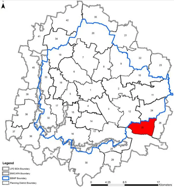
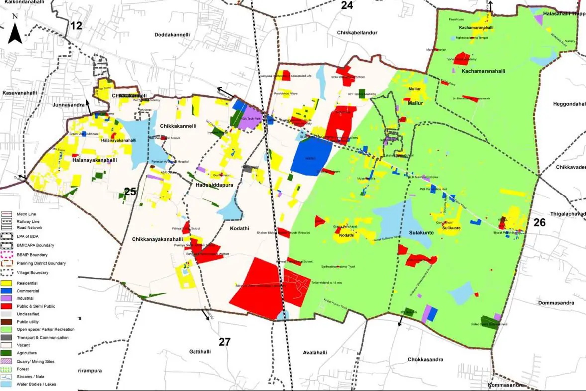
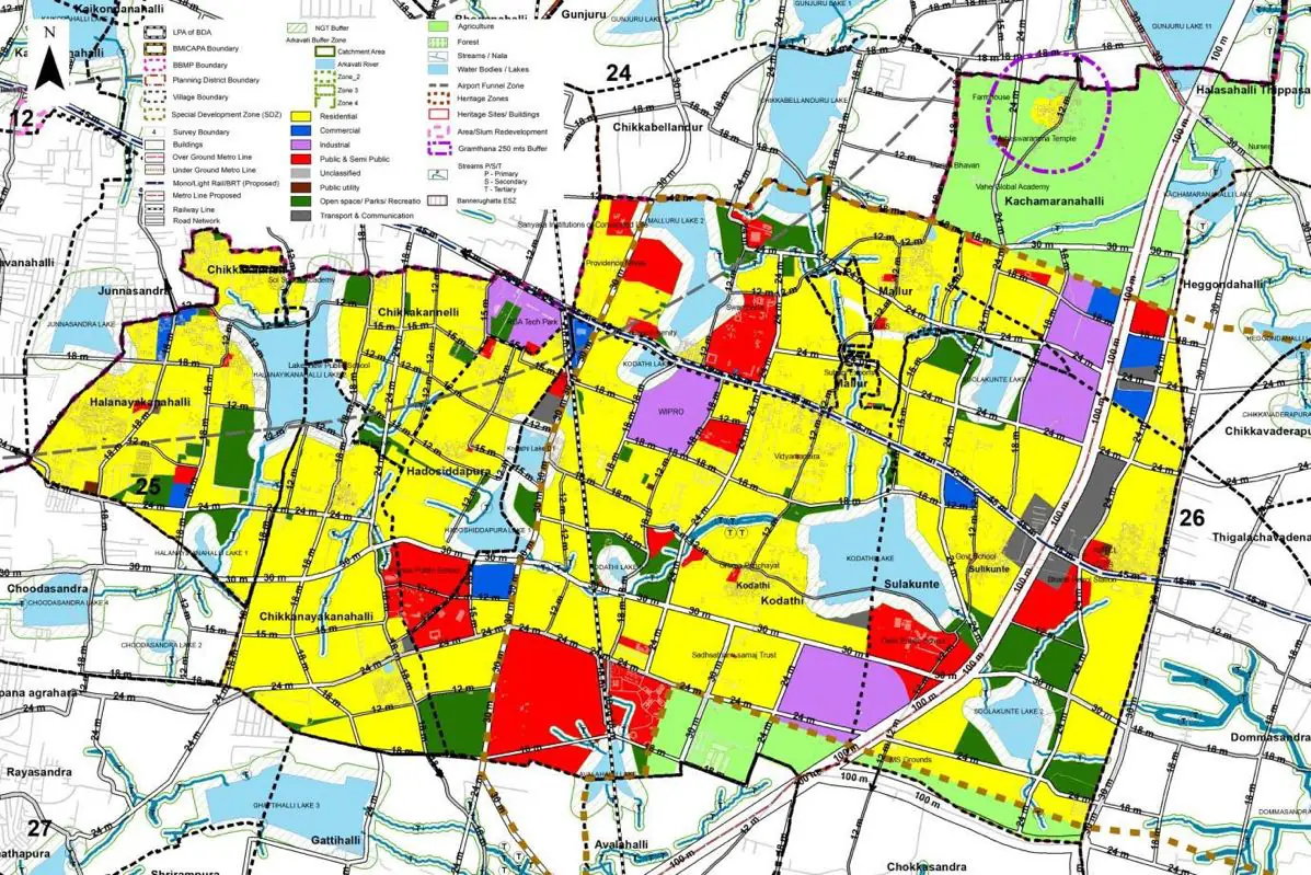
1. Planning District 25 comprises of eight villages falling under two Gram Panchayats, namely Halanayikanahalli, Chikkanayikanahalli, Hadoshiddapura, Chikkakannelli, (all falling under Halanayakanahalli Gram Panchayat), Soolakunte, Kodathi, Mulluru and Kachamaranahalli (all falling under Kodathi Gram Panchayat).
The Existing Land Use Map and Proposed Land Use Map for this PD are in the Planning District Report (PDF). Open the document and go to this PD’s section; use the List of Figures to find “PD 25 Existing Land Use Map” and “PD 25 Proposed Land Use Map”.
| Land use Category | Area (in Ha) | Percentage to Total Area (%) |
|---|---|---|
| Residential | 146.78 | 7.34 |
| Commercial | 9.20 | 0.46 |
| Industrial | 14.40 | 0.72 |
| Quarry/ Mining Sites | 0.00 | 0.00 |
| Public & Semi Public | 98.18 | 4.91 |
| Unclassified | 0.00 | 0.00 |
| Public Utility | 0.00 | 0.00 |
| Parks & Open Spaces | 15.40 | 0.77 |
| Transport & Communication | 55.39 | 2.77 |
| Vacant | 274.55 | 13.73 |
| Agriculture | 1308.95 | 65.46 |
| Forest | 0.00 | 0.00 |
| Streams | 0.00 | 0.00 |
| Water Bodies | 73.39 | 3.67 |
| NGT Buffer | 0.00 | 0.00 |
| Other | 1.40 | 0.07 |
| Total | 1999.70 | 100.00 |
| Land use Category | Area (in Ha) | Percentage To Total Developable Area (%) |
|---|---|---|
| Residential | 955.49 | 47.78 |
| Commercial | 26.99 | 1.35 |
| Industrial | 97.18 | 4.86 |
| Quarry/ Mining Sites | 0.00 | 0.00 |
| Public & Semi Public | 171.97 | 8.60 |
| Unclassified | 0.00 | 0.00 |
| Public Utility | 0.00 | 0.00 |
| Parks & Open Spaces | 115.98 | 5.80 |
| Transport & Communication | 233.97 | 11.70 |
| Vacant | 0.00 | 0.00 |
| Agriculture | 0.00 | 0.00 |
| Forest | 0.00 | 0.00 |
| Streams | 0.00 | 0.00 |
| Water Bodies | 79.19 | 3.96 |
| NGT Buffer | 316.75 | 15.84 |
| Other | 1.80 | 0.09 |
| Total Developable Area | 1999.32 | , |
Total PD Area 1999.70 Ha. Source: Revised Master Plan 2031 (Draft) Volume-4.
Road Development Plan, Public Transport System, Multimodal Interchange Stations, Parks and Open Spaces, Protection and Rejuvenation of Lakes and Streams, Area Redevelopment, Heritage Area Protection and Conservation, Physical Infrastructure, Disaster Mitigation.