Demography
Population (2011)
51,092
Census 2011
Area
2138.3 Ha
21.38 sq.km
Gross Density
24 PPH
Persons per Hectare
Wards/Villages
7
Outside BBMP
Southern BMA. Electronic City Phase I & II, Infosys, HCL, Velankini, BHEL, Arvind Mills. 129.89% decadal growth. ELCITA township. 30 schools; IIIT, Sikkim Manipal. No metered water/sewage. 2 metro stations (Electronics City 2, Huskur Road).
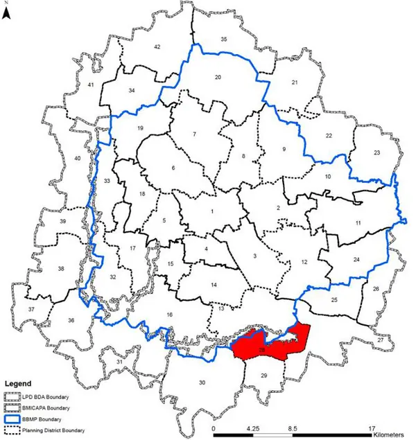
Villages in PD: 7 Gross Density : 23.9 pph Electronic City – Doddathoguru Planning District is located at the southern quadrant of BMA, outside the BBMP jurisdiction, at the south side of the NICE corridor. The PD has seen high decadal growth rate owing to the Electronic City Phase that is located here and its accessibility to the NICE corridor. The Revised Master Plan 2031 proposes limited development activities, whilst rest of area is proposed to agriculture land use, owing to the existing pattern of development and activities.
1. The Doddathoguru – Electronic City PD comprises of 7 villages, Hommadevanahalli, Doddanagamangala (part in BMICAPA), Doddathoguru (part in BMICAPA), Konappana Agrahara (part in BMICAPA), Mylasandra, Bettadasanapura, and Vittasandra.
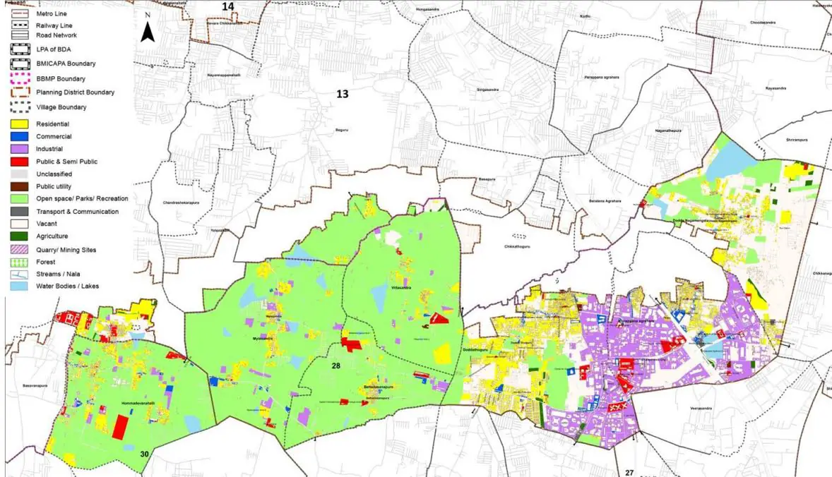
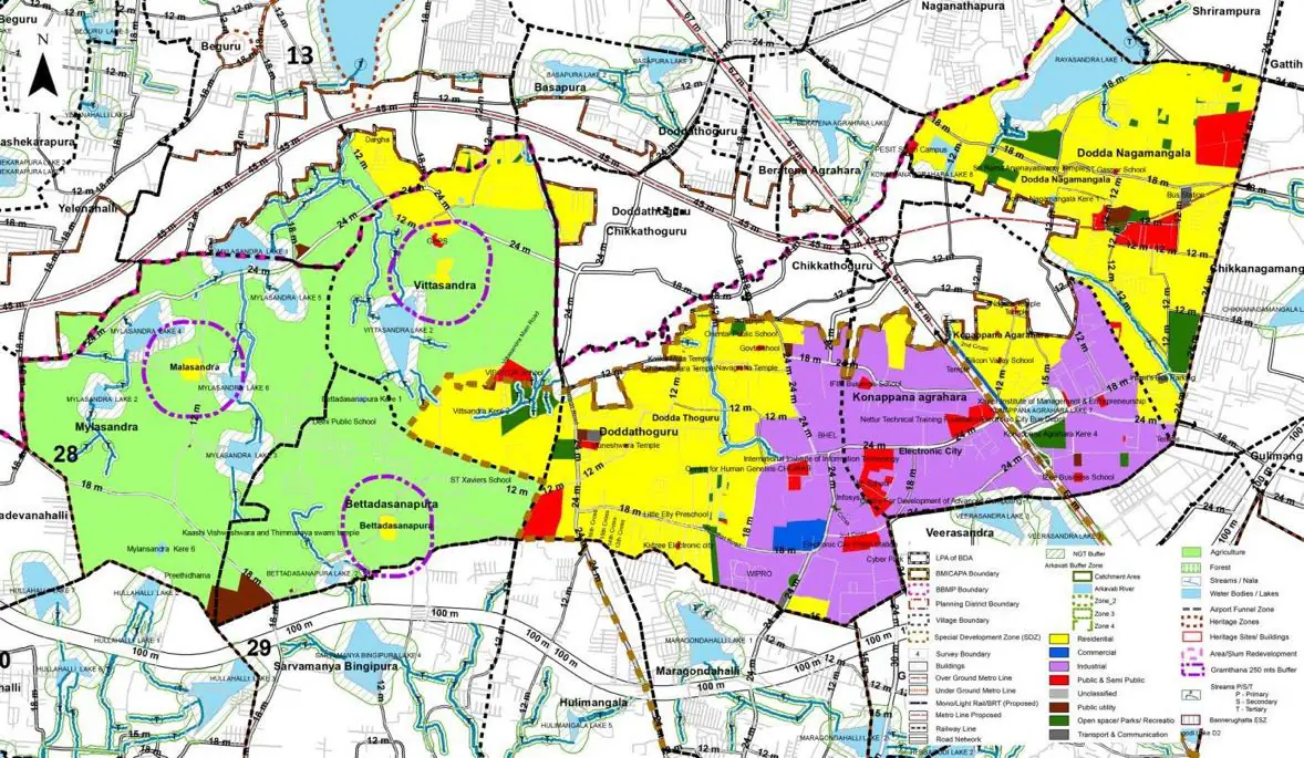
The Existing Land Use Map and Proposed Land Use Map for this PD are in the Planning District Report (PDF). Open the document and go to this PD’s section; use the List of Figures to find “PD 28 Existing Land Use Map” and “PD 28 Proposed Land Use Map”.
| Land use Category | Area (in Ha) | Percentage to Total Area (%) |
|---|---|---|
| Residential | 276.27 | 12.92 |
| Commercial | 29.12 | 1.36 |
| Industrial | 287.34 | 13.44 |
| Quarry/ Mining Sites | 0.00 | 0.00 |
| Public & Semi Public | 36.78 | 1.72 |
| Unclassified | 0.00 | 0.00 |
| Public Utility | 0.00 | 0.00 |
| Parks & Open Spaces | 11.97 | 0.56 |
| Transport & Communication | 95.58 | 4.47 |
| Vacant | 349.30 | 16.34 |
| Agriculture | 858.33 | 40.14 |
| Forest | 0.00 | 0.00 |
| Streams | 0.00 | 0.00 |
| Water Bodies | 67.14 | 3.14 |
| NGT Buffer | 0.00 | 0.00 |
| Other | 123.40 | 5.77 |
| Total | 2138.30 | 100.00 |
| Land use Category | Area (in Ha) | Percentage To Total Developable Area (%) |
|---|---|---|
| Residential | 1020.27 | 47.71 |
| Commercial | 16.04 | 0.75 |
| Industrial | 537.61 | 25.14 |
| Quarry/ Mining Sites | 0.00 | 0.00 |
| Public & Semi Public | 103.26 | 4.83 |
| Unclassified | 0.00 | 0.00 |
| Public Utility | 0.00 | 0.00 |
| Parks & Open Spaces | 72.03 | 3.37 |
| Transport & Communication | 208.70 | 9.76 |
| Vacant | 0.00 | 0.00 |
| Agriculture | 0.00 | 0.00 |
| Forest | 0.00 | 0.00 |
| Streams | 0.00 | 0.00 |
| Water Bodies | 54.10 | 2.53 |
| NGT Buffer | 117.18 | 5.48 |
| Other | 7.06 | 0.33 |
| Total Developable Area | 2136.25 | , |
Total PD Area 2138.30 Ha. Source: Revised Master Plan 2031 (Draft) Volume-4.
Road Development Plan, Public Transport System, Multimodal Interchange Stations, Parks and Open Spaces, Protection and Rejuvenation of Lakes and Streams, Area Redevelopment, Heritage Area Protection and Conservation, Physical Infrastructure, Disaster Mitigation.