Demography
Population (2011)
23,390
Census 2011
Area
2953.5 Ha
29.54 sq.km
Gross Density
8 PPH
Persons per Hectare
Wards/Villages
16
Outside BBMP
North-west BMA. 54.8% decadal growth. Arakavati River, T.G. Halli Reservoir buffer (Zone 1,3,4), part Hesaraghatta Reservoir. 11 schools; Sidaganga PU, IIHR, Acharya Nursing. KSCA cricket ground Aluru. BDA housing in Aluru. Entire PD preserved as agriculture; village development.
A. Existing Situation
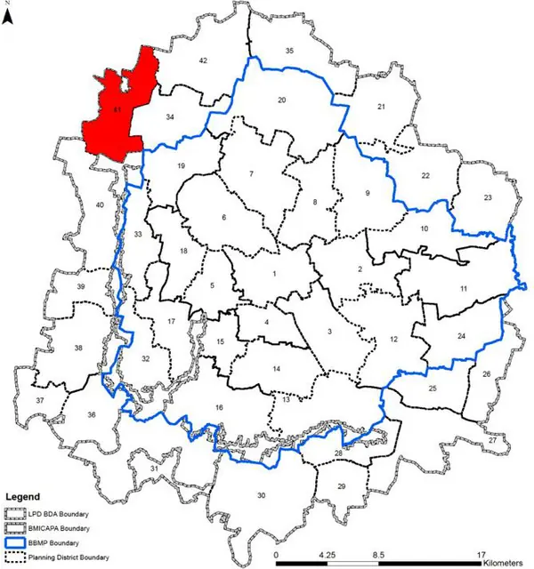
1. The Aluru Planning District admeasures 2953.51 Ha (29.53 sq km) comprises of 16 revenue villages namely, Thammarasanahalli, Hurlichikkanahalli, Kodagithirumalapura, Bilajaji, Hessaraghatta (Part), Tharabanahalli, Sasiveghatta and Ivarakandapura villages in Hessaraghatta Hobli and Nagasandra, Narasipura, Muniyanapalya, Thammenahalli, Kuduragere, Aluru, Heggadadevanapura and Hanumanthasagara villages of Dasanapura Hobli. All these villages are under different by Gram Panchayats, namely Madanayakanahalli, Aluru, Huskur, Hurlichikkanahalli, and Hesaraghatta.
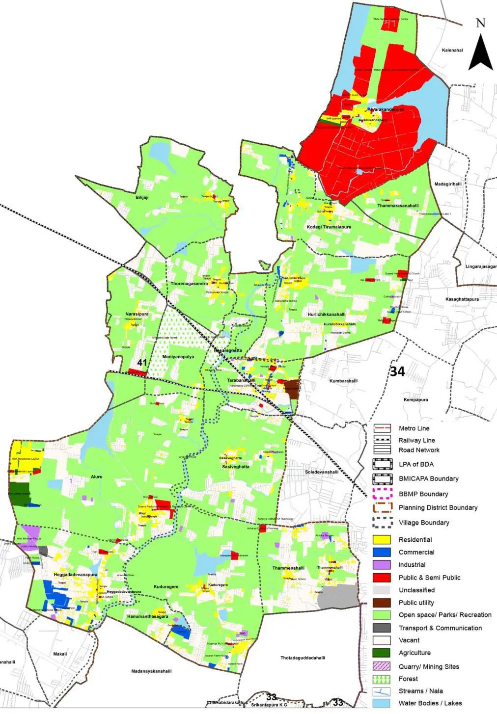
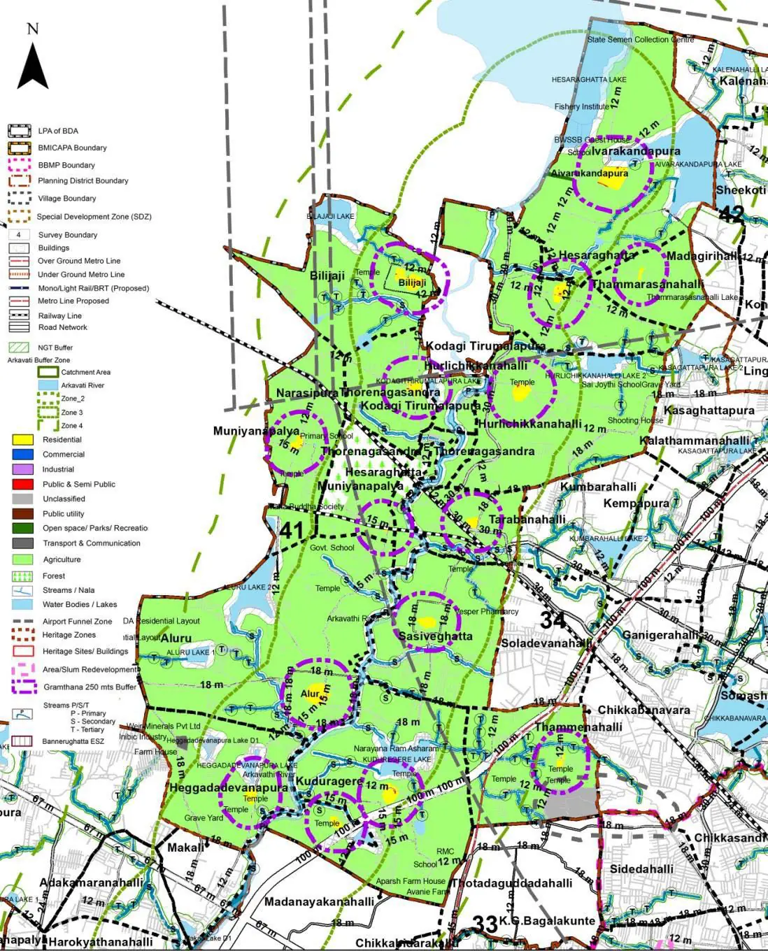
The Existing Land Use Map and Proposed Land Use Map for this PD are in the Planning District Report (PDF). Open the document and go to this PD’s section; use the List of Figures to find “PD 41 Existing Land Use Map” and “PD 41 Proposed Land Use Map”.
| Land use Category | Area (in Ha) | Percentage to Total Area (%) |
|---|---|---|
| Residential | 135.03 | 4.57 |
| Commercial | 24.22 | 0.82 |
| Industrial | 14.18 | 0.48 |
| Quarry/ Mining Sites | 0.00 | 0.00 |
| Public & Semi Public | 245.44 | 8.31 |
| Unclassified | 18.02 | 0.61 |
| Public Utility | 0.00 | 0.00 |
| Parks & Open Spaces | 13.59 | 0.46 |
| Transport & Communication | 127.59 | 4.32 |
| Vacant | 570.32 | 19.31 |
| Agriculture | 1583.27 | 53.61 |
| Forest | 48.73 | 1.65 |
| Streams | 0.00 | 0.00 |
| Water Bodies | 138.52 | 4.69 |
| NGT Buffer | 0.00 | 0.00 |
| Other | 28.93 | 0.98 |
| Total | 2953.50 | 100.00 |
| Land use Category | Area (in Ha) | Percentage To Total Developable Area (%) |
|---|---|---|
| Residential | 0.00 | 0.00 |
| Commercial | 0.00 | 0.00 |
| Industrial | 0.00 | 0.00 |
| Quarry/ Mining Sites | 0.00 | 0.00 |
| Public & Semi Public | 0.00 | 0.00 |
| Unclassified | 0.00 | 0.00 |
| Public Utility | 2.07 | 0.07 |
| Parks & Open Spaces | 0.00 | 0.00 |
| Transport & Communication | 0.00 | 0.00 |
| Vacant | 0.00 | 0.00 |
| Agriculture | 0.00 | 0.00 |
| Forest | 0.00 | 0.00 |
| Streams | 0.00 | 0.00 |
| Water Bodies | 0.00 | 0.00 |
| NGT Buffer | 0.00 | 0.00 |
| Other | 0.00 | 0.00 |
| Total Developable Area | 2.07 | , |
Total PD Area 2953.50 Ha. Source: Revised Master Plan 2031 (Draft) Volume-4.
Road Development Plan, Public Transport System, Multimodal Interchange Stations, Parks and Open Spaces, Protection and Rejuvenation of Lakes and Streams, Area Redevelopment, Heritage Area Protection and Conservation, Physical Infrastructure, Disaster Mitigation.