Demography
Population (2011)
22,541
Census 2011
Area
4150.9 Ha
41.51 sq.km
Gross Density
5 PPH
Persons per Hectare
Wards/Villages
22
Outside BBMP
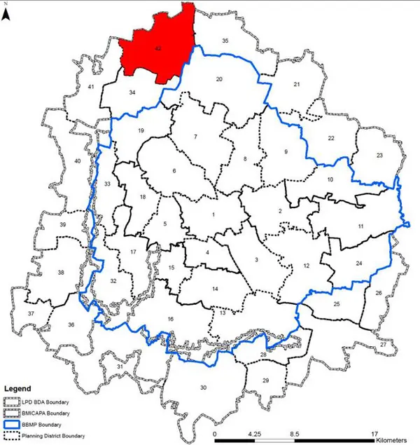
Northern periphery BMA, boundary BIAAPA. 22 villages, 4 GPs. 28 lakes (Shinganayakanahalli Amanikere largest), Jarakabande Reserved Forest, Bylekere Peacock Sanctuary, Madappanahalli Forest. Zone 4 Arakavati Conservation. KMF Cattle Feed, RTO Test Track, ICTS, ICAR. Doddaballapura Road. 67.23% agriculture; growth along Doddaballapura and Rajanakunte–Adiganahalli.
Villages in PD: 22 Gram Panchayats: Sheekoti, Rajanakunte, Shinganayakanahalli, and Vaderahalli Rajanakunte Planning District (Planning District no. 42) is located in northern periphery in BMA and shares its boundary with LPA of BIAPPA. PD is environmentally sensitive with 28 lakes, Jarakabande Reserved Forest/ Avalahalli Fores and Bylekere Peacock Santury. The Revised Master Plan 2031 proposes that except for village settlements, the PD be preserved as agriculture zone and environmental protection.
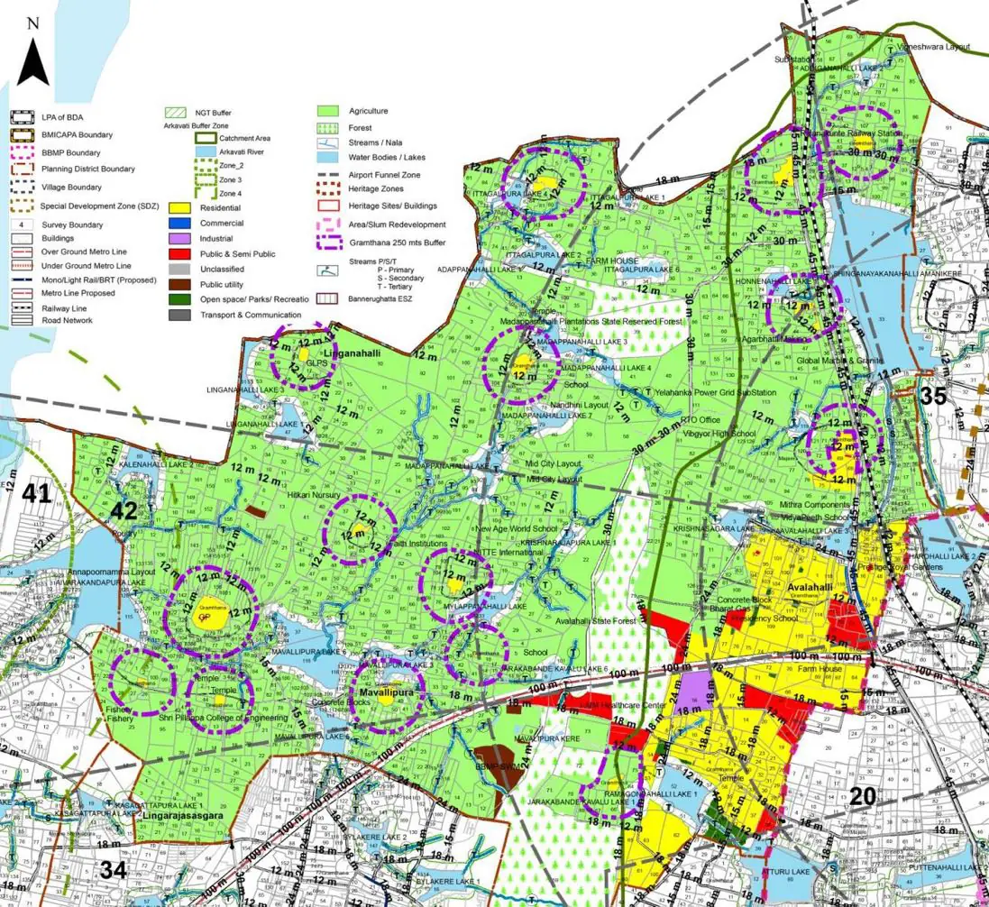
The Existing Land Use Map and Proposed Land Use Map for this PD are in the Planning District Report (PDF). Open the document and go to this PD’s section; use the List of Figures to find “PD 42 Existing Land Use Map” and “PD 42 Proposed Land Use Map”.
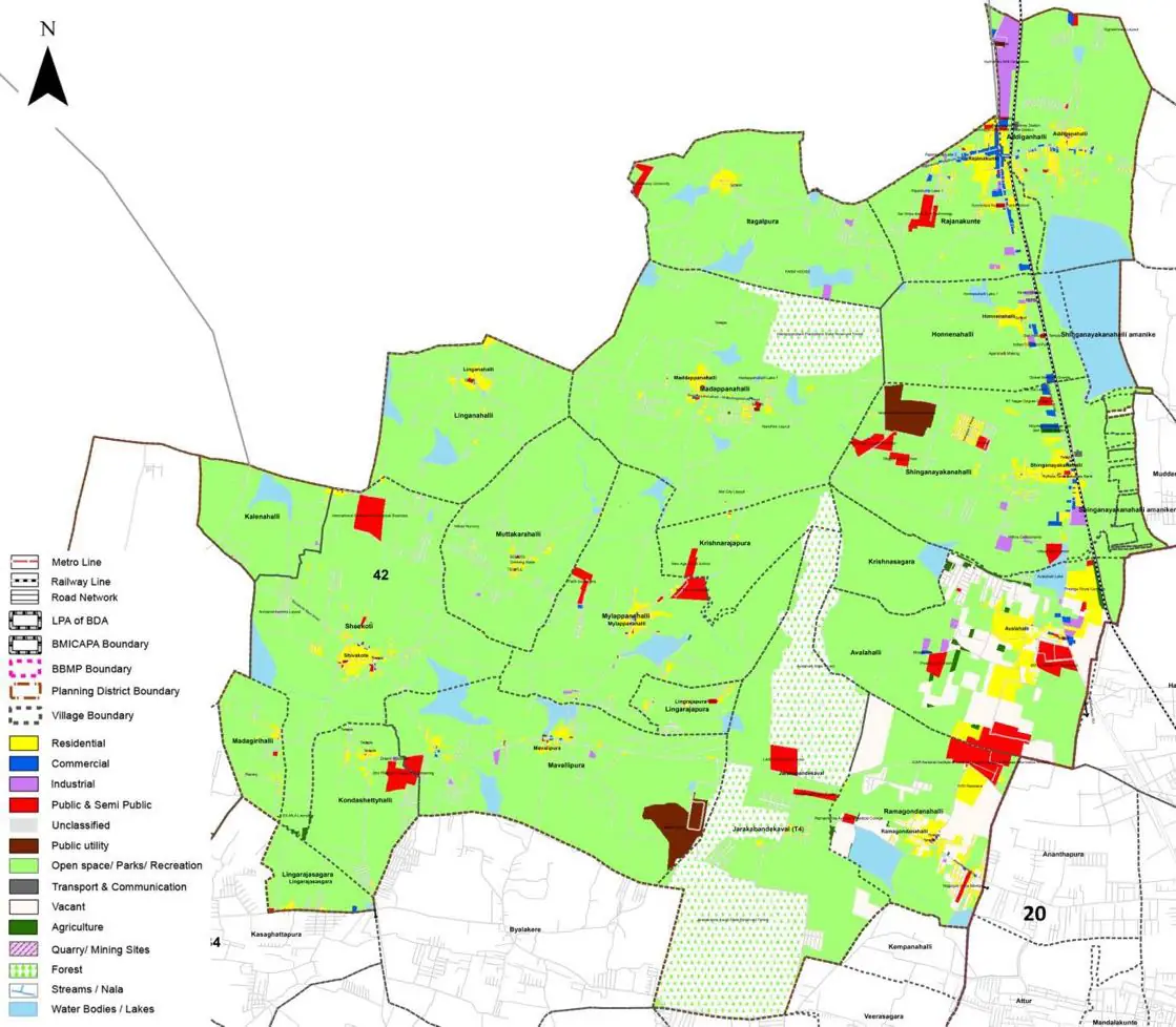
| Land use Category | Area (in Ha) | Percentage to Total Area (%) |
|---|---|---|
| Residential | 145.70 | 3.51 |
| Commercial | 15.77 | 0.38 |
| Industrial | 24.91 | 0.60 |
| Quarry/ Mining Sites | 0.00 | 0.00 |
| Public & Semi Public | 80.94 | 1.95 |
| Unclassified | 0.00 | 0.00 |
| Public Utility | 30.30 | 0.73 |
| Parks & Open Spaces | 9.13 | 0.22 |
| Transport & Communication | 65.17 | 1.57 |
| Vacant | 450.37 | 10.85 |
| Agriculture | 2790.35 | 67.22 |
| Forest | 333.42 | 8.03 |
| Streams | 0.00 | 0.00 |
| Water Bodies | 197.17 | 4.75 |
| NGT Buffer | 0.00 | 0.00 |
| Other | 7.89 | 0.19 |
| Total | 4150.90 | 100.00 |
| Land use Category | Area (in Ha) | Percentage To Total Developable Area (%) |
|---|---|---|
| Residential | 2555.00 | 61.55 |
| Commercial | 26.15 | 0.63 |
| Industrial | 100.87 | 2.43 |
| Quarry/ Mining Sites | 0.00 | 0.00 |
| Public & Semi Public | 371.92 | 8.96 |
| Unclassified | 0.00 | 0.00 |
| Public Utility | 0.00 | 0.00 |
| Parks & Open Spaces | 102.94 | 2.48 |
| Transport & Communication | 541.39 | 13.04 |
| Vacant | 0.00 | 0.00 |
| Agriculture | 0.00 | 0.00 |
| Forest | 25.32 | 0.61 |
| Streams | 0.00 | 0.00 |
| Water Bodies | 156.90 | 3.78 |
| NGT Buffer | 262.75 | 6.33 |
| Other | 6.64 | 0.16 |
| Total Developable Area | 4149.88 | , |
Total PD Area 4150.90 Ha. Source: Revised Master Plan 2031 (Draft) Volume-4.
Road Development Plan, Public Transport System, Multimodal Interchange Stations, Parks and Open Spaces, Protection and Rejuvenation of Lakes and Streams, Area Redevelopment, Heritage Area Protection and Conservation, Physical Infrastructure, Disaster Mitigation.