Demography
Population (2011)
593,883
Census 2011
Area
2774.3 Ha
27.74 sq.km
Gross Density
214 PPH
Persons per Hectare
Wards/Villages
19
Within BBMP
CBD and Administrative Centre for Karnataka. Houses Vidhan Soudha, Vikas Soudha, Raj Bhavan, K.R.Market, Pete Area, Cubbon Park, Majestic Bus Stand. Witnessed negative decadal growth rate with increasing commercial activities.
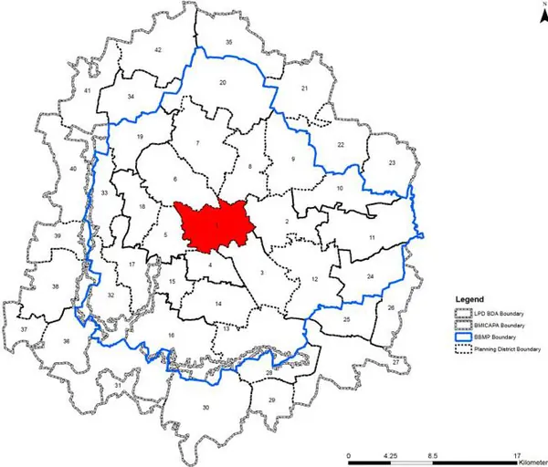
1. The Central District is the CBD and Administrative Centre for the State. The extent admeasures 2774.3 Ha (27.74 sq km) comprising of 19 wards, - Jayamahal (63), Gayathri Nagar (76), Pulkeshi Nagar (78), Ulsoor (90), Bharath Nagar (91), Shivaji Nagar (92), Vasanth Nagar (93), Gandhi Nagar (94), Subash Nagar (95), Okalipuram (96), Dayanand Nagar (97), Prakash nagar (98), Chickpete (109), Sampanigaram (110), Shantala Nagar (111), Sudam Nagar (118), Dharamarayaswamt Temple ward (119), Cottonpet (120) and K.R.Market (139) and covers parts of West, East and South zone of BBMP.
2. Vidhan Soudha, Vikas Soudha, Raj Bhavan, K.R.Market, Pete Area, Cubbon Park, Majestic Bus Stand, Chinnaswamy Stadium, etc. are located within this PD.
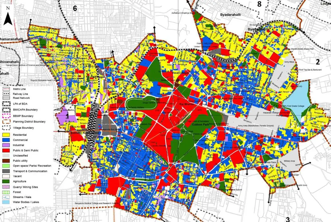
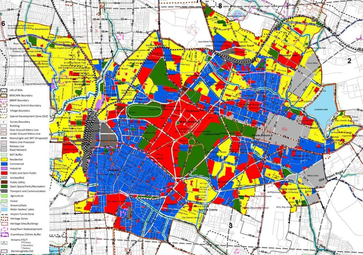
The Existing Land Use Map and Proposed Land Use Map for this PD are in the Planning District Report (PDF). Open the document and go to this PD’s section; use the List of Figures to find “PD 1 Existing Land Use Map” and “PD 1 Proposed Land Use Map”.
| Land use Category | Area (in Ha) | Percentage to Total Area (%) |
|---|---|---|
| Residential | 676.19 | 24.37 |
| Commercial | 585.89 | 21.12 |
| Industrial | 54.38 | 1.96 |
| Quarry/ Mining Sites | 0.00 | 0.00 |
| Public & Semi Public | 458.29 | 16.52 |
| Unclassified | 0.00 | 0.00 |
| Public Utility | 0.00 | 0.00 |
| Parks & Open Spaces | 230.54 | 8.31 |
| Transport & Communication | 430.83 | 15.53 |
| Vacant | 102.09 | 3.68 |
| Agriculture | 0.00 | 0.00 |
| Forest | 0.00 | 0.00 |
| Streams | 0.00 | 0.00 |
| Water Bodies | 43.00 | 1.55 |
| NGT Buffer | 0.00 | 0.00 |
| Other | 193.09 | 6.96 |
| Total | 2774.30 | 100.00 |
| Land use Category | Area (in Ha) | Percentage To Total Developable Area (%) |
|---|---|---|
| Residential | 477.18 | 17.20 |
| Commercial | 434.73 | 15.67 |
| Industrial | 3.88 | 0.14 |
| Quarry/ Mining Sites | 0.00 | 0.00 |
| Public & Semi Public | 306.82 | 11.06 |
| Unclassified | 0.00 | 0.00 |
| Public Utility | 0.00 | 0.00 |
| Parks & Open Spaces | 150.92 | 5.44 |
| Transport & Communication | 372.59 | 13.43 |
| Vacant | 0.00 | 0.00 |
| Agriculture | 0.00 | 0.00 |
| Forest | 0.00 | 0.00 |
| Streams | 0.00 | 0.00 |
| Water Bodies | 0.55 | 0.02 |
| NGT Buffer | 115.69 | 4.17 |
| Other | 98.77 | 3.56 |
| Total Developable Area | 1961.13 | , |
Total PD Area 2774.30 Ha. Source: Revised Master Plan 2031 (Draft) Volume-4.
Road Development Plan, Public Transport System, Multimodal Interchange Stations, Parks and Open Spaces, Protection and Rejuvenation of Lakes and Streams, Area Redevelopment, Heritage Area Protection and Conservation, Physical Infrastructure, Disaster Mitigation.