Demography
Population (2011)
424,517
Census 2011
Area
3022.6 Ha
30.23 sq.km
Gross Density
140 PPH
Persons per Hectare
Wards/Villages
10
Within BBMP
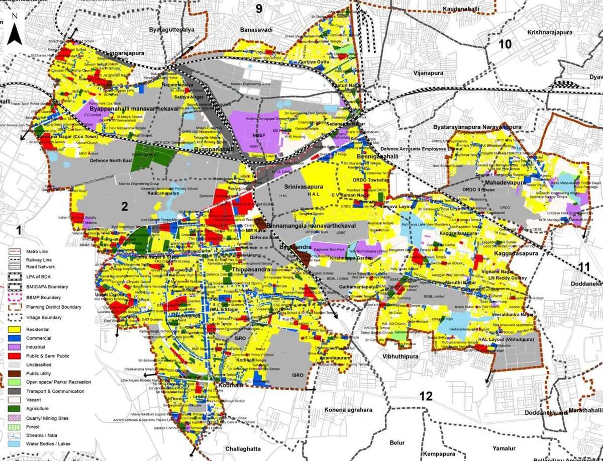
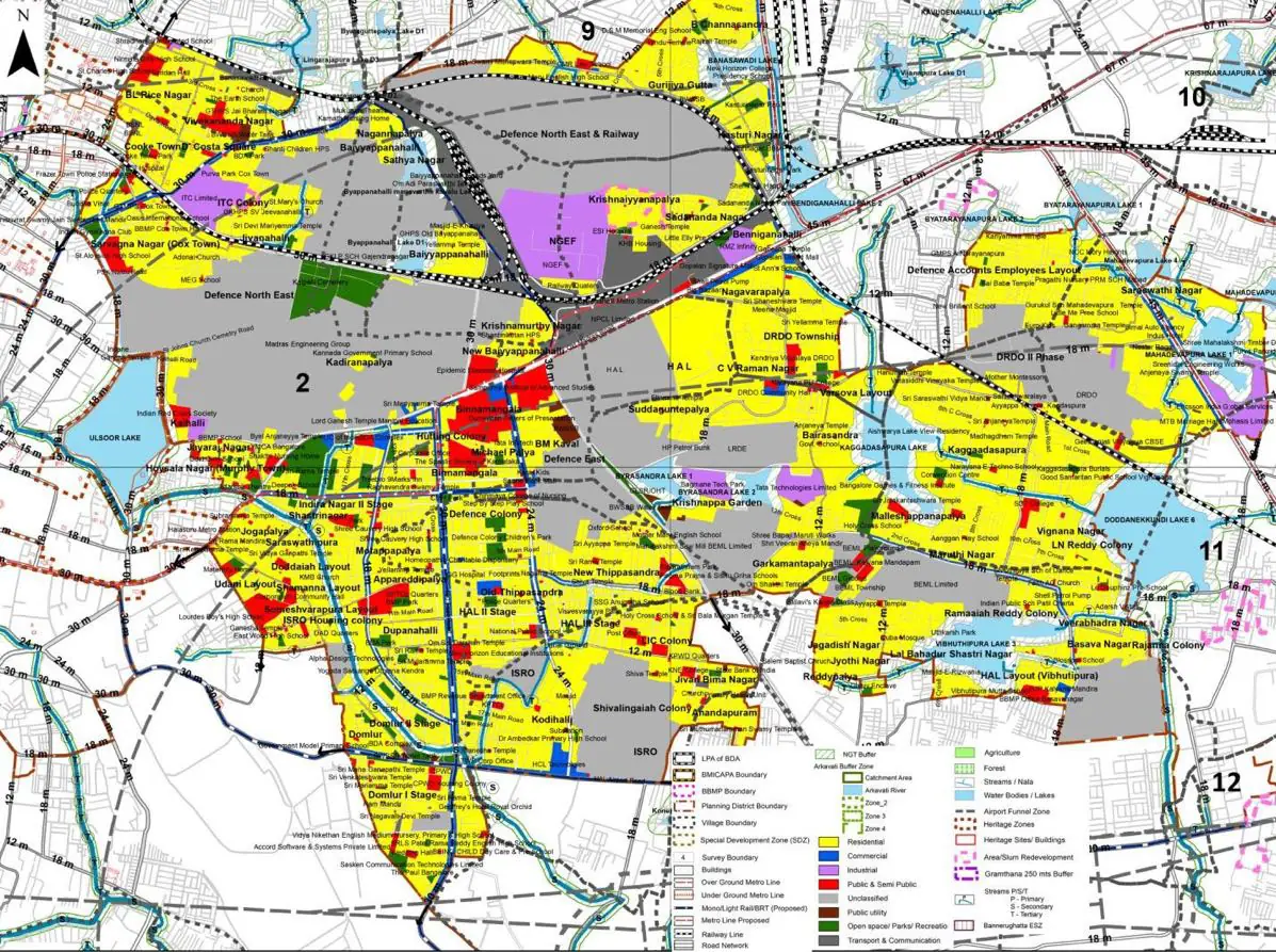
Core BMA area characterized by large public sector enterprises (BEML, ISRO, NAL, HAL), planned residential layouts, DRDO Township and Tech Parks. Decadal growth rate 27.41%.
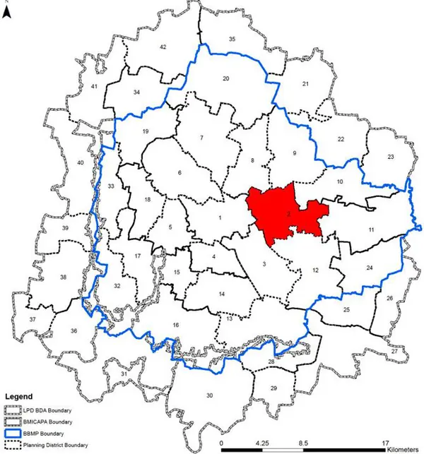
1. The Indiranagar -Kagadasapura comprises of 10 wards, - and covers parts of West, East and South zone of BBMP of 10 wards namely Benniganahal- li (50), C.V.Raman Nagar (57), Hosathippasandra (58), Maruthiseva Nagar (59), Sarvagna Nagar (79), Hoysala Nagar (80), Vignana Nagar (81), Jeevanbhima Nagar (88), Jogupalya (89) and Dommalur (112); all falling within the Bangalore East administrative zone of BBMP.
2. Public sector enterprises like BEML, ISRO, NAL, HAL, and Defence area along with Commercial Area of Indira Nagar/ Domluru, and Tech Parks like Bagamane, World Centre, RMZ Infinity Tech Park etc are the major employment centres within this planning district.
The Existing Land Use Map and Proposed Land Use Map for this PD are in the Planning District Report (PDF). Open the document and go to this PD’s section; use the List of Figures to find “PD 2 Existing Land Use Map” and “PD 2 Proposed Land Use Map”.
| Land use Category | Area (in Ha) | Percentage to Total Area (%) |
|---|---|---|
| Residential | 1000.49 | 33.10 |
| Commercial | 137.83 | 4.56 |
| Industrial | 106.40 | 3.52 |
| Quarry/ Mining Sites | 0.00 | 0.00 |
| Public & Semi Public | 113.65 | 3.76 |
| Unclassified | 0.00 | 0.00 |
| Public Utility | 0.00 | 0.00 |
| Parks & Open Spaces | 79.19 | 2.62 |
| Transport & Communication | 422.86 | 13.99 |
| Vacant | 280.20 | 9.27 |
| Agriculture | 0.00 | 0.00 |
| Forest | 0.00 | 0.00 |
| Streams | 0.00 | 0.00 |
| Water Bodies | 72.54 | 2.40 |
| NGT Buffer | 0.00 | 0.00 |
| Other | 809.46 | 26.78 |
| Total | 3022.62 | 100.00 |
| Land use Category | Area (in Ha) | Percentage To Total Developable Area (%) |
|---|---|---|
| Residential | 1275.85 | 42.21 |
| Commercial | 47.76 | 1.58 |
| Industrial | 93.40 | 3.09 |
| Quarry/ Mining Sites | 0.00 | 0.00 |
| Public & Semi Public | 107.30 | 3.55 |
| Unclassified | 0.00 | 0.00 |
| Public Utility | 0.00 | 0.00 |
| Parks & Open Spaces | 73.45 | 2.43 |
| Transport & Communication | 392.34 | 12.98 |
| Vacant | 0.00 | 0.00 |
| Agriculture | 0.00 | 0.00 |
| Forest | 0.00 | 0.00 |
| Streams | 0.00 | 0.00 |
| Water Bodies | 61.06 | 2.02 |
| NGT Buffer | 209.47 | 6.93 |
| Other | 761.99 | 25.21 |
| Total Developable Area | 3022.62 | , |
Total PD Area 3022.62 Ha. Source: Revised Master Plan 2031 (Draft) Volume-4.
Road Development Plan, Public Transport System, Multimodal Interchange Stations, Parks and Open Spaces, Protection and Rejuvenation of Lakes and Streams, Area Redevelopment, Heritage Area Protection and Conservation, Physical Infrastructure, Disaster Mitigation.