Demography
Population (2011)
380,778
Census 2011
Area
3083.0 Ha
30.83 sq.km
Gross Density
124 PPH
Persons per Hectare
Wards/Villages
9
Within BBMP
South of CBD. Start-up hub centered on Koramangala with several IT clusters. Planned layouts including HSR Layout. Home to Holy Trinity Church, Forum Mall, Air Force Command Hospital.
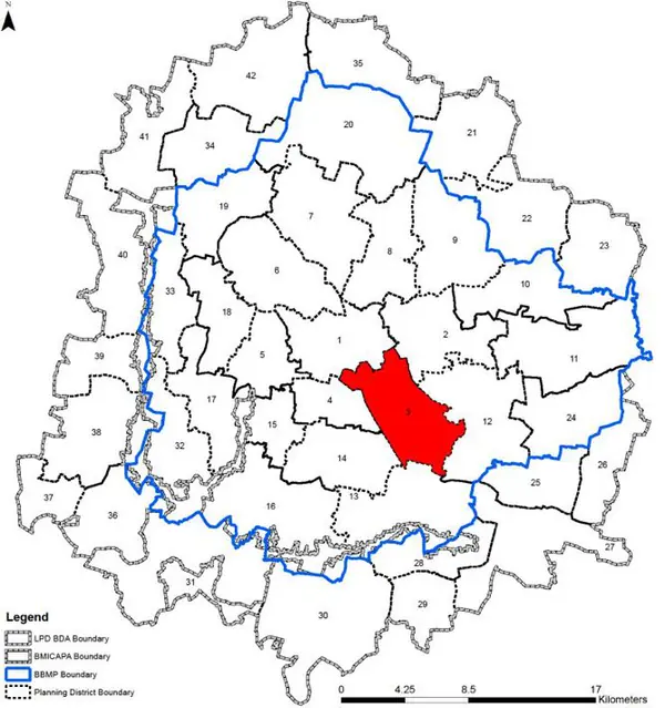
1. The Koramangala planning district is located within the inner core of the city. The extent admeasures 3083.02 ha (30.83 sq km) and comprises of 9 BBMP wards – namely Agaram (114), Neelasandra (116), Shanthi Nagar (117), Vannarpet (115) in Bangalore East zone, Adugodi (147), Ejipura (148), Koramangala (151), Jakkasandra (173) wards in Bangalore South Zone of the BBMP and HSR Layout (174) falling within the Bommanahalli Zone of the BBMP.
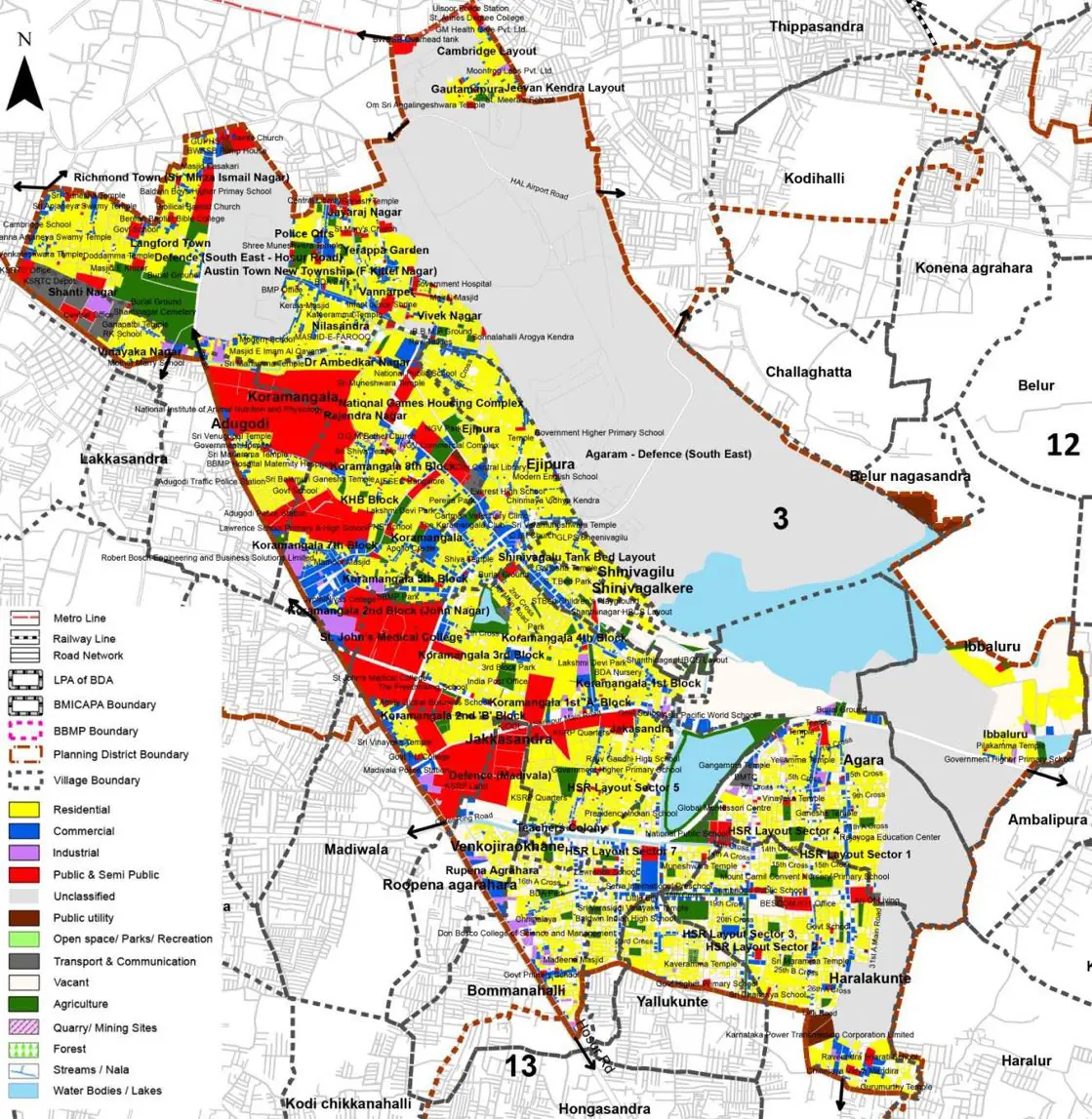
2. Soŵe ŵajoƌ laŶdŵaƌks aƌe iŶ this PD aƌe HolLJ TƌiŶitLJ ChuƌĐh, JohŶsoŶ Maƌket, St JohŶ͛s Hospital, Forum Mall and the Air Force Command Hospital.
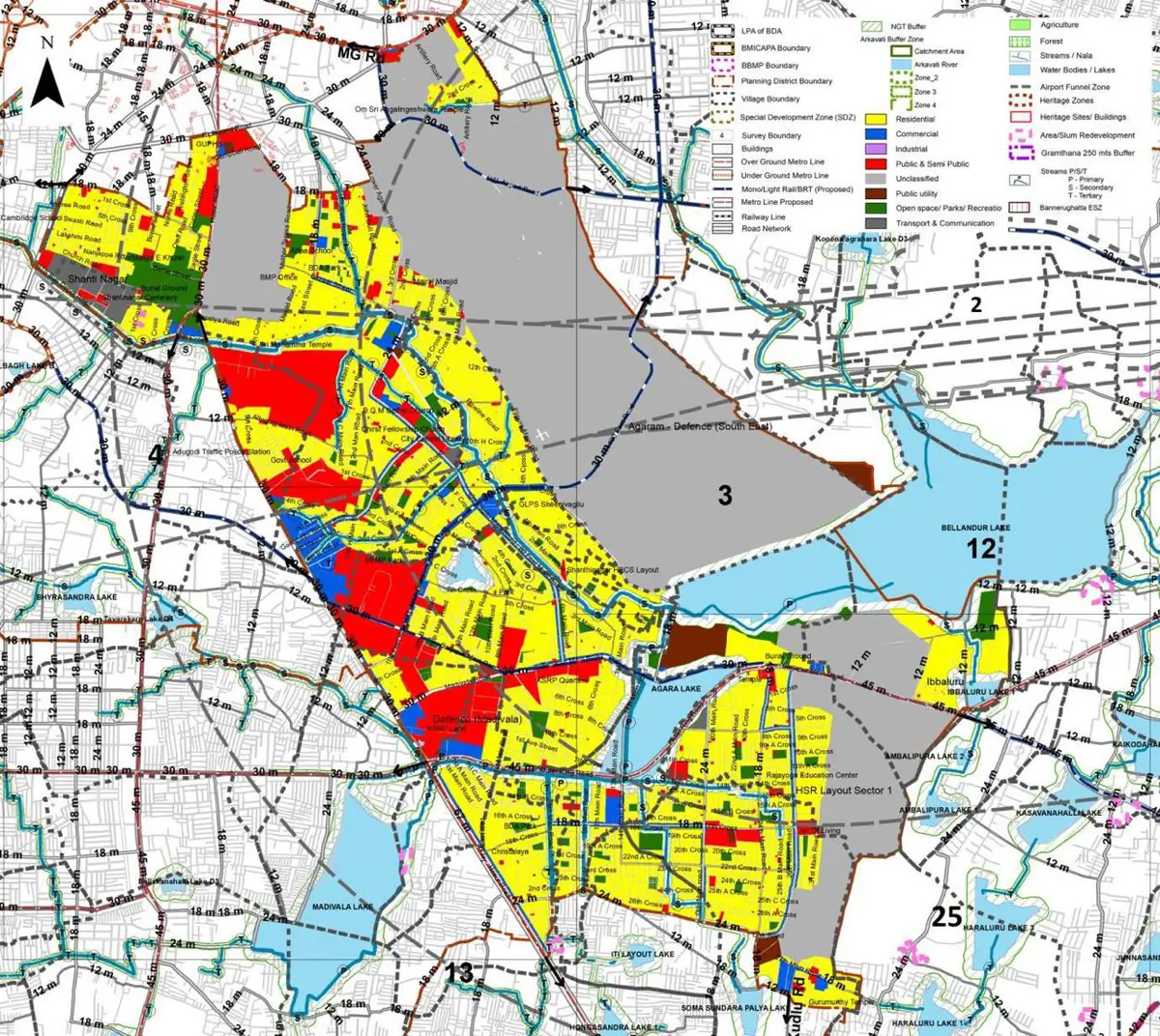
The Existing Land Use Map and Proposed Land Use Map for this PD are in the Planning District Report (PDF). Open the document and go to this PD’s section; use the List of Figures to find “PD 3 Existing Land Use Map” and “PD 3 Proposed Land Use Map”.
| Land use Category | Area (in Ha) | Percentage to Total Area (%) |
|---|---|---|
| Residential | 720.18 | 23.36 |
| Commercial | 155.08 | 5.03 |
| Industrial | 34.53 | 1.12 |
| Quarry/ Mining Sites | 0.00 | 0.00 |
| Public & Semi Public | 267.61 | 8.68 |
| Unclassified | 0.00 | 0.00 |
| Public Utility | 0.00 | 0.00 |
| Parks & Open Spaces | 102.66 | 3.33 |
| Transport & Communication | 295.05 | 9.57 |
| Vacant | 294.43 | 9.55 |
| Agriculture | 0.00 | 0.00 |
| Forest | 0.00 | 0.00 |
| Streams | 0.00 | 0.00 |
| Water Bodies | 175.12 | 5.68 |
| NGT Buffer | 0.00 | 0.00 |
| Other | 1038.36 | 33.68 |
| Total | 3083.02 | 100.00 |
| Land use Category | Area (in Ha) | Percentage To Total Developable Area (%) |
|---|---|---|
| Residential | 1005.07 | 32.60 |
| Commercial | 78.31 | 2.54 |
| Industrial | 0.00 | 0.00 |
| Quarry/ Mining Sites | 0.00 | 0.00 |
| Public & Semi Public | 282.51 | 9.16 |
| Unclassified | 0.00 | 0.00 |
| Public Utility | 0.00 | 0.00 |
| Parks & Open Spaces | 102.05 | 3.31 |
| Transport & Communication | 387.23 | 12.56 |
| Vacant | 0.00 | 0.00 |
| Agriculture | 0.00 | 0.00 |
| Forest | 0.00 | 0.00 |
| Streams | 0.00 | 0.00 |
| Water Bodies | 155.08 | 5.03 |
| NGT Buffer | 209.95 | 6.81 |
| Other | 861.83 | 27.95 |
| Total Developable Area | 3082.03 | , |
Total PD Area 3083.02 Ha. Source: Revised Master Plan 2031 (Draft) Volume-4.
Road Development Plan, Public Transport System, Multimodal Interchange Stations, Parks and Open Spaces, Protection and Rejuvenation of Lakes and Streams, Area Redevelopment, Heritage Area Protection and Conservation, Physical Infrastructure, Disaster Mitigation.