Demography
Population (2011)
346,593
Census 2011
Area
1481.9 Ha
14.82 sq.km
Gross Density
234 PPH
Persons per Hectare
Wards/Villages
10
Within BBMP
Origins of South Bengaluru. Famous for Lal Bagh, Bull Temple, Gandhi Bazar, Jayanagar 4th Block. Deep heritage and culture. Transitioning from residential to mixed-use. Growth rate only 1.2%.
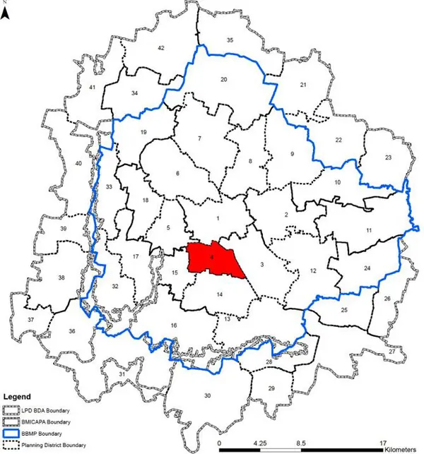
1. The planning district comprises of 10 wards which include, Sunkenahalli (142), Visvesvarapuram (143), Siddapura (144), Hombegowda Nagar (145), Lakkasandra (146), Sudduguntepalya (152), Jayangar (153), Basavangudi(154), Yadiyuru (167), and Byrasandra (169) and covers parts of West, East and South zone of BBMP.
2. Some of the important landmarks in the PD are: Lal Bagh, Yadiyur lake, Krishna Rao Park, Bull temple, National College, BMS College, Christ College, Nimhans, Karnataka Milk Federation, Mico Bosch, Shanti Nagar TTMC, Jayanagar 4th Block Market, Food Street at VV Puram, and Gandhi Bazar.
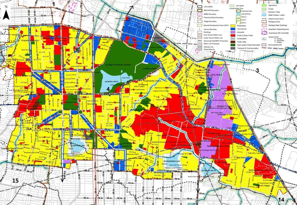
The Existing Land Use Map and Proposed Land Use Map for this PD are in the Planning District Report (PDF). Open the document and go to this PD’s section; use the List of Figures to find “PD 4 Existing Land Use Map” and “PD 4 Proposed Land Use Map”.
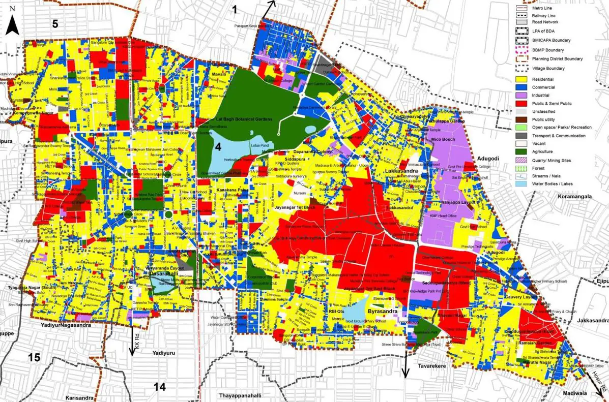
| Land use Category | Area (in Ha) | Percentage to Total Area (%) |
|---|---|---|
| Residential | 557.83 | 37.64 |
| Commercial | 177.09 | 11.95 |
| Industrial | 70.09 | 4.73 |
| Quarry/ Mining Sites | 0.00 | 0.00 |
| Public & Semi Public | 256.96 | 17.34 |
| Unclassified | 0.00 | 0.00 |
| Public Utility | 0.00 | 0.00 |
| Parks & Open Spaces | 119.59 | 8.07 |
| Transport & Communication | 197.24 | 13.31 |
| Vacant | 65.94 | 4.45 |
| Agriculture | 0.00 | 0.00 |
| Forest | 0.00 | 0.00 |
| Streams | 0.00 | 0.00 |
| Water Bodies | 26.23 | 1.77 |
| NGT Buffer | 0.00 | 0.00 |
| Other | 9.93 | 0.67 |
| Total | 1481.90 | 100.00 |
| Land use Category | Area (in Ha) | Percentage To Total Developable Area (%) |
|---|---|---|
| Residential | 323.15 | 21.81 |
| Commercial | 55.42 | 3.74 |
| Industrial | 32.16 | 2.17 |
| Quarry/ Mining Sites | 0.00 | 0.00 |
| Public & Semi Public | 125.96 | 8.50 |
| Unclassified | 0.00 | 0.00 |
| Public Utility | 0.00 | 0.00 |
| Parks & Open Spaces | 64.02 | 4.32 |
| Transport & Communication | 135.29 | 9.13 |
| Vacant | 0.00 | 0.00 |
| Agriculture | 0.00 | 0.00 |
| Forest | 0.00 | 0.00 |
| Streams | 0.00 | 0.00 |
| Water Bodies | 13.63 | 0.92 |
| NGT Buffer | 39.27 | 2.65 |
| Other | 693.61 | 46.81 |
| Total Developable Area | 1482.51 | , |
Total PD Area 1481.90 Ha. Source: Revised Master Plan 2031 (Draft) Volume-4.
Road Development Plan, Public Transport System, Multimodal Interchange Stations, Parks and Open Spaces, Protection and Rejuvenation of Lakes and Streams, Area Redevelopment, Heritage Area Protection and Conservation, Physical Infrastructure, Disaster Mitigation.