Demography
Population (2011)
621,302
Census 2011
Area
3483.1 Ha
34.83 sq.km
Gross Density
178 PPH
Persons per Hectare
Wards/Villages
16
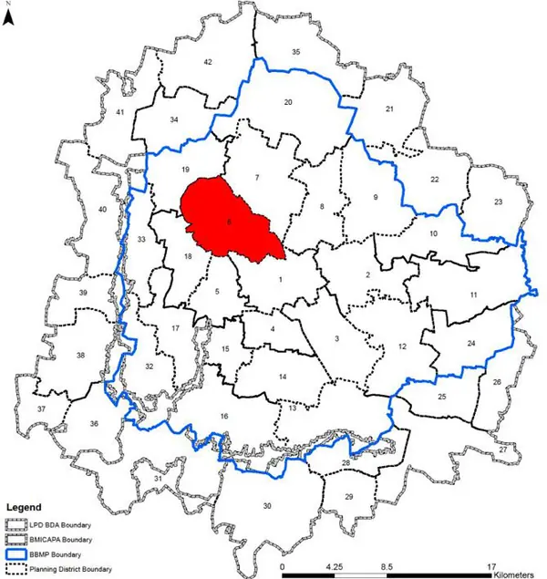
Within BBMP
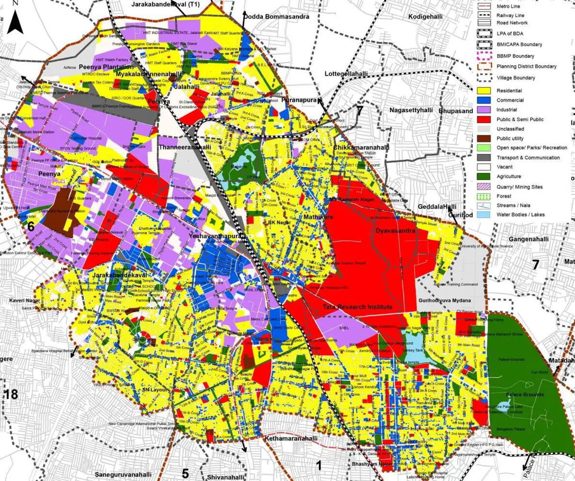
Extends from Malleshwaram to Yeshwantpur/HMT. Houses IISc, Bangalore Palace, Chowdiah Memorial Hall, Iskcon Temple, Orion Mall. Major industrial areas including HMT, BEL, BHEL, Peenya.
1. The Yeshwanthpur Malleshwaram Planning District predominantly is within the core area (Planning Zone A). It extends from Malleshwaram to Yeswantpur/ HMT area and admeasures 2774.3 ha (27.74 sq km). It comprises of 16 BBMP wards – namely Aramane Nagar (35), Mathik- ere (36), Nandini Layout (43), Marappana Palya (44), Malleshwaram(45), Rajamahal (64), Kadumalleshwara (65), Subramanya Nagar(66), Nagapura(67), Mahalakshmipuram(68), Datathreya Temple(77) in the Bangalore West Zone of the BBMP and Jalahalli (16), J.P.Park (17), Yeshwanthpur (37), H.M.T (38), Lakshmidevi Nagar (42) in the Raja- rajeshwari Nagar Zone of the BBMP.
2. Landmark cultural institutions such as the iconic Chowdiah Memorial Hall, the Iskcon Temple, the Bangalore Place, the educational institutions like Indian Institute of Science, Indian Institute of Wood Science; Industrial area of Yeswantpur and Part of Peenya Industrial Area, Sandal Soap factory; traditional Malleshwaram market to modern shopping experience - Orion Mall, Residential areas like Nandini Layout, Jalahalli, Malleshwaram, Ashwath Nagar, and Large open spaces like Place Grounds and JP Park defines the vibrant characteristics of Yeswantpur – Malleshwaram Planning District.
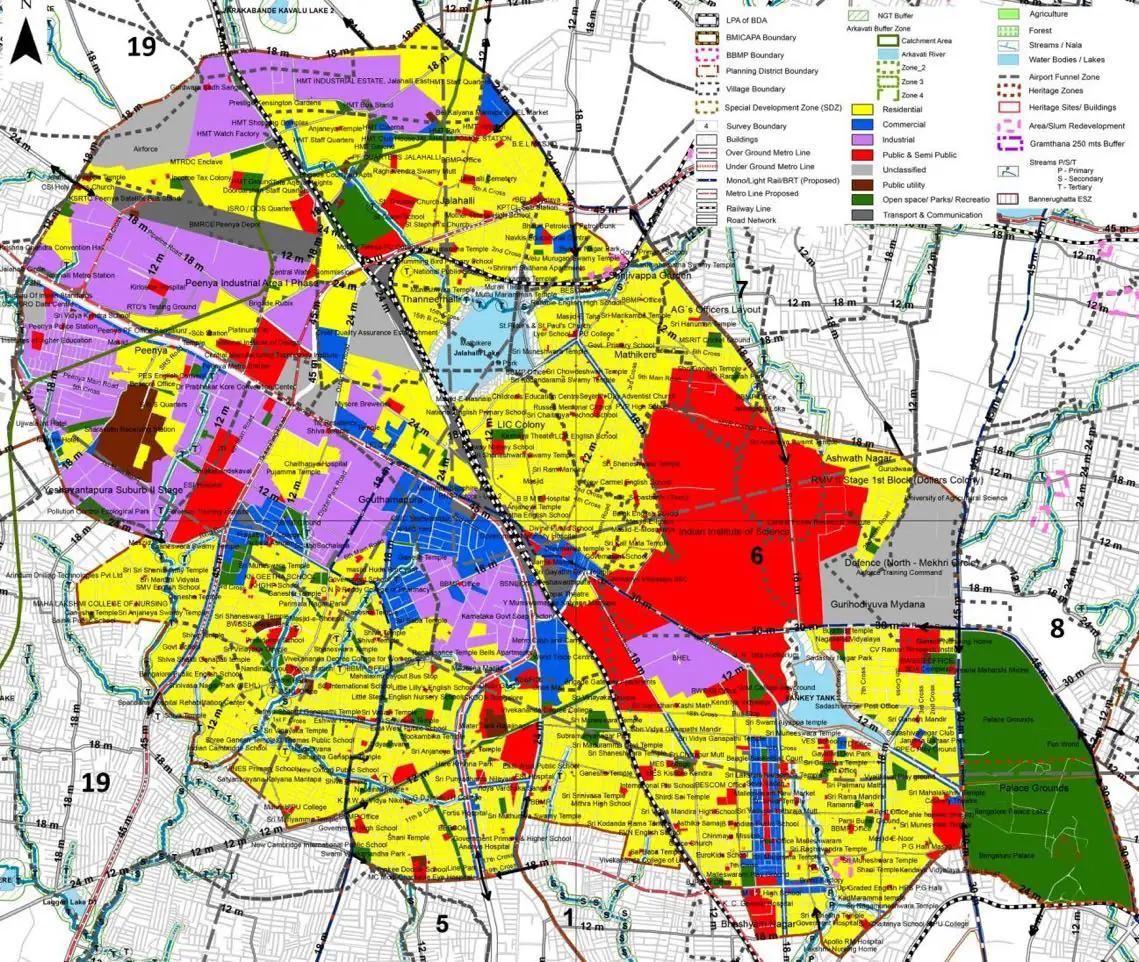
The Existing Land Use Map and Proposed Land Use Map for this PD are in the Planning District Report (PDF). Open the document and go to this PD’s section; use the List of Figures to find “PD 6 Existing Land Use Map” and “PD 6 Proposed Land Use Map”.
| Land use Category | Area (in Ha) | Percentage to Total Area (%) |
|---|---|---|
| Residential | 1041.68 | 29.91 |
| Commercial | 261.23 | 7.50 |
| Industrial | 422.15 | 12.12 |
| Quarry/ Mining Sites | 0.00 | 0.00 |
| Public & Semi Public | 488.68 | 14.03 |
| Unclassified | 0.00 | 0.00 |
| Public Utility | 0.00 | 0.00 |
| Parks & Open Spaces | 297.11 | 8.53 |
| Transport & Communication | 499.28 | 14.33 |
| Vacant | 271.68 | 7.80 |
| Agriculture | 0.00 | 0.00 |
| Forest | 0.00 | 0.00 |
| Streams | 0.00 | 0.00 |
| Water Bodies | 24.03 | 0.69 |
| NGT Buffer | 0.00 | 0.00 |
| Other | 176.24 | 5.06 |
| Total | 3483.08 | 100.00 |
| Land use Category | Area (in Ha) | Percentage To Total Developable Area (%) |
|---|---|---|
| Residential | 1103.44 | 31.68 |
| Commercial | 147.69 | 4.24 |
| Industrial | 386.62 | 11.10 |
| Quarry/ Mining Sites | 0.00 | 0.00 |
| Public & Semi Public | 401.30 | 11.52 |
| Unclassified | 0.00 | 0.00 |
| Public Utility | 0.00 | 0.00 |
| Parks & Open Spaces | 235.11 | 6.75 |
| Transport & Communication | 521.77 | 14.98 |
| Vacant | 0.00 | 0.00 |
| Agriculture | 0.00 | 0.00 |
| Forest | 0.00 | 0.00 |
| Streams | 0.00 | 0.00 |
| Water Bodies | 0.00 | 0.00 |
| NGT Buffer | 180.77 | 5.19 |
| Other | 507.06 | 14.56 |
| Total Developable Area | 3483.76 | , |
Total PD Area 3483.08 Ha. Source: Revised Master Plan 2031 (Draft) Volume-4.
Road Development Plan, Public Transport System, Multimodal Interchange Stations, Parks and Open Spaces, Protection and Rejuvenation of Lakes and Streams, Area Redevelopment, Heritage Area Protection and Conservation, Physical Infrastructure, Disaster Mitigation.