Demography
Population (2011)
496,056
Census 2011
Area
3923.0 Ha
39.23 sq.km
Gross Density
126 PPH
Persons per Hectare
Wards/Villages
12
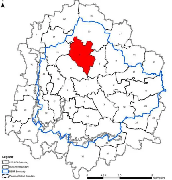
Within BBMP
Central North of BMA. Bellary Road to KIA, GKVK (Biodiversity Heritage Site), BEL, defence institutions. 7 lakes including Hebbal. Decadal growth 57.6%.
1. The Hebbal Planning District comprises of 12 wards namely Byatarayanapura (7), Kodigehalli (8), Vidyaranyapura (9), Doddabommasandra (10), Radhakrishna Temple (18), Sanjay Nagar (19), Ganga Nagar (20), Hebbal (21), Vishwa nathnagenahalli (22), Manorayanapalya (33), Gangenahalli (34) and Jayachamarajendra Nagar (46).
2. Bellary Road providing connectivity to Kempegowda International Airport/ Hyderabad, Outer Ring Road, Jayamahal Road, New BEL Road, Sanjay Nagar Main Road, Dasarahalli Main Road, Kodigehalli Main Road, Vidyaranyapura Road, etc define the overall road network of the PD.
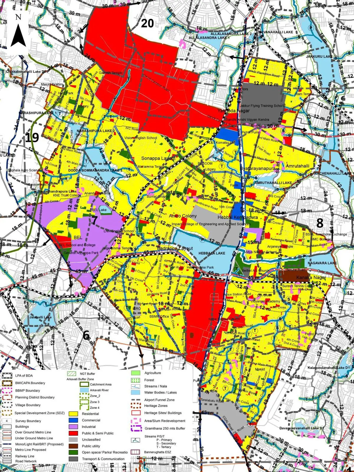
The Existing Land Use Map and Proposed Land Use Map for this PD are in the Planning District Report (PDF). Open the document and go to this PD’s section; use the List of Figures to find “PD 7 Existing Land Use Map” and “PD 7 Proposed Land Use Map”.
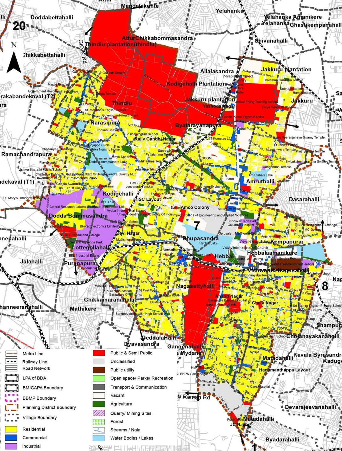
| Land use Category | Area (in Ha) | Percentage to Total Area (%) |
|---|---|---|
| Residential | 1278.45 | 32.59 |
| Commercial | 151.04 | 3.85 |
| Industrial | 200.86 | 5.12 |
| Quarry/ Mining Sites | 0.00 | 0.00 |
| Public & Semi Public | 846.20 | 21.57 |
| Unclassified | 0.00 | 0.00 |
| Public Utility | 0.00 | 0.00 |
| Parks & Open Spaces | 101.21 | 2.58 |
| Transport & Communication | 377.20 | 9.62 |
| Vacant | 664.56 | 16.94 |
| Agriculture | 0.00 | 0.00 |
| Forest | 0.00 | 0.00 |
| Streams | 0.00 | 0.00 |
| Water Bodies | 140.64 | 3.58 |
| NGT Buffer | 0.00 | 0.00 |
| Other | 164.42 | 4.19 |
| Total | 3923.02 | 100.00 |
| Land use Category | Area (in Ha) | Percentage To Total Developable Area (%) |
|---|---|---|
| Residential | 1713.58 | 43.68 |
| Commercial | 65.12 | 1.66 |
| Industrial | 177.71 | 4.53 |
| Quarry/ Mining Sites | 0.00 | 0.00 |
| Public & Semi Public | 730.47 | 18.62 |
| Unclassified | 0.00 | 0.00 |
| Public Utility | 0.00 | 0.00 |
| Parks & Open Spaces | 96.90 | 2.47 |
| Transport & Communication | 559.81 | 14.27 |
| Vacant | 0.00 | 0.00 |
| Agriculture | 0.00 | 0.00 |
| Forest | 0.00 | 0.00 |
| Streams | 0.00 | 0.00 |
| Water Bodies | 134.95 | 3.44 |
| NGT Buffer | 288.34 | 7.35 |
| Other | 155.69 | 3.97 |
| Total Developable Area | 3922.57 | , |
Total PD Area 3923.02 Ha. Source: Revised Master Plan 2031 (Draft) Volume-4.
Road Development Plan, Public Transport System, Multimodal Interchange Stations, Parks and Open Spaces, Protection and Rejuvenation of Lakes and Streams, Area Redevelopment, Heritage Area Protection and Conservation, Physical Infrastructure, Disaster Mitigation.