Demography
Population (2011)
622,667
Census 2011
Area
2798.6 Ha
27.99 sq.km
Gross Density
222 PPH
Persons per Hectare
Wards/Villages
14
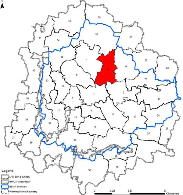
Within BBMP
Centre-north of BBMP. Manyata Tech Park is major employer. Thanisandra had 252% growth. Richards Town heritage area with Colonial bungalows. Hyper-dense wards within ORR (450-650 pph).
TOWN
1. PD consists of 14 BBMP wards and namely - Thanisandra(6), Nagavara(23), HBR Layout(24), Kammanahalli(28), Kacharakanahalli(29), Kadugondanahalli(30), Kushal Nagar(31), Kavalbyrasandra(32), Devarajeevanahalli(47), Muneshwara Nagar(48), Lingarajapura(49) and Sagayapuram(60), SK Garden (61) and Ramaswamy Palya (62)
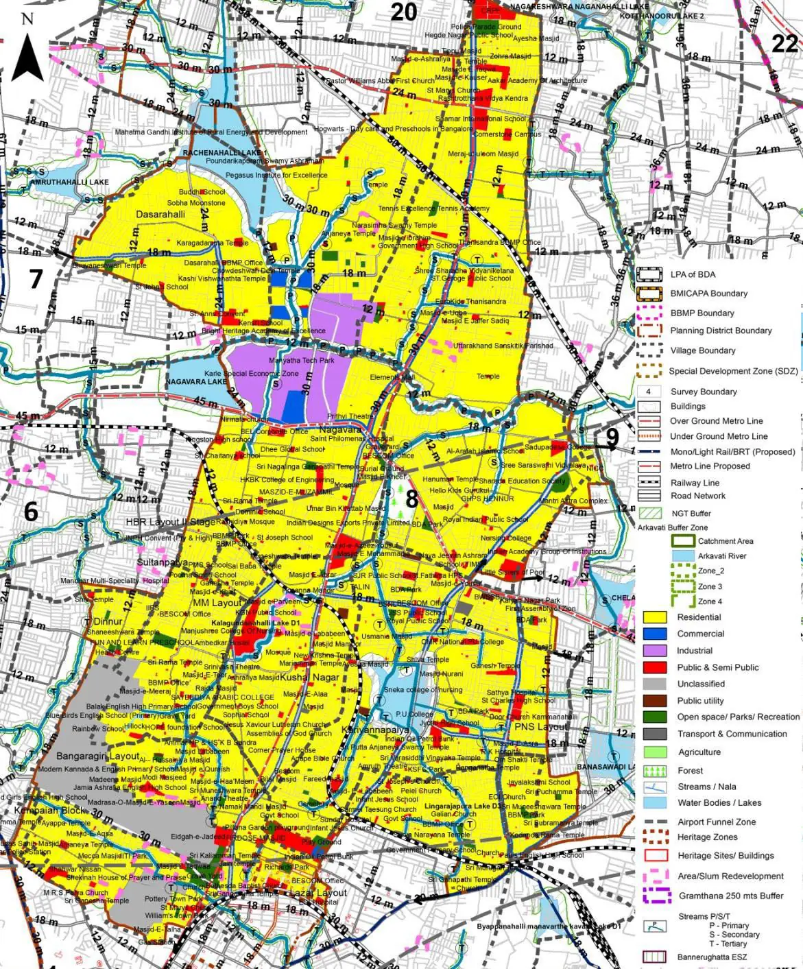
The Existing Land Use Map and Proposed Land Use Map for this PD are in the Planning District Report (PDF). Open the document and go to this PD’s section; use the List of Figures to find “PD 8 Existing Land Use Map” and “PD 8 Proposed Land Use Map”.
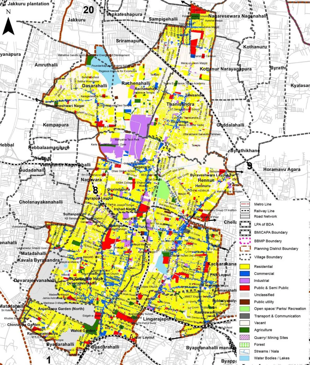
| Land use Category | Area (in Ha) | Percentage to Total Area (%) |
|---|---|---|
| Residential | 1114.08 | 39.81 |
| Commercial | 160.64 | 5.74 |
| Industrial | 106.07 | 3.79 |
| Quarry/ Mining Sites | 0.00 | 0.00 |
| Public & Semi Public | 116.70 | 4.17 |
| Unclassified | 0.00 | 0.00 |
| Public Utility | 0.00 | 0.00 |
| Parks & Open Spaces | 48.14 | 1.72 |
| Transport & Communication | 292.46 | 10.45 |
| Vacant | 734.36 | 26.24 |
| Agriculture | 0.00 | 0.00 |
| Forest | 0.00 | 0.00 |
| Streams | 0.00 | 0.00 |
| Water Bodies | 48.42 | 1.73 |
| NGT Buffer | 0.00 | 0.00 |
| Other | 178.37 | 6.37 |
| Total | 2798.64 | 100.00 |
| Land use Category | Area (in Ha) | Percentage To Total Developable Area (%) |
|---|---|---|
| Residential | 1701.00 | 60.78 |
| Commercial | 55.97 | 2.00 |
| Industrial | 70.80 | 2.53 |
| Quarry/ Mining Sites | 0.00 | 0.00 |
| Public & Semi Public | 100.19 | 3.58 |
| Unclassified | 0.00 | 0.00 |
| Public Utility | 0.00 | 0.00 |
| Parks & Open Spaces | 35.82 | 1.28 |
| Transport & Communication | 325.58 | 11.63 |
| Vacant | 0.00 | 0.00 |
| Agriculture | 0.00 | 0.00 |
| Forest | 0.00 | 0.00 |
| Streams | 0.00 | 0.00 |
| Water Bodies | 47.58 | 1.70 |
| NGT Buffer | 292.74 | 10.46 |
| Other | 168.96 | 6.04 |
| Total Developable Area | 2798.64 | , |
Total PD Area 2798.64 Ha. Source: Revised Master Plan 2031 (Draft) Volume-4.
Road Development Plan, Public Transport System, Multimodal Interchange Stations, Parks and Open Spaces, Protection and Rejuvenation of Lakes and Streams, Area Redevelopment, Heritage Area Protection and Conservation, Physical Infrastructure, Disaster Mitigation.