Demography
Population (2011)
207,212
Census 2011
Area
4238.4 Ha
42.38 sq.km
Gross Density
49 PPH
Persons per Hectare
Wards/Villages
4
Within BBMP
Major employment centre on eastern BMA edge. IT/ITES/Aerospace companies in ITPB, KIADB, Bagamane Tech Park. Population doubled with 127.57% growth. 45.73% vacant land.
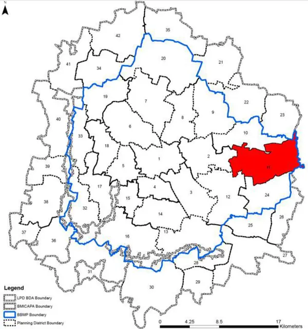
1. Planning District comprises of four large BBMP wards, namely Gurudacharpalya (82), Kadugodi (83). Hagadooru (84) and Doddanekkundi (85).
2. It houses number of IT/ ITES/ Aerospace Companies in ITPB, KIADB Export Promotion Industrial Area, Bagamane Tech Park and other IT premises and has Dodde Nakundi Industrial Areas, Vishweshwarya Industrial Estates. The residential developments are mostly of high density and unplanned in nature. The PD has potential to accommodate additional population and at the same time redevelopment/ upgradation of certain areas is seen required.
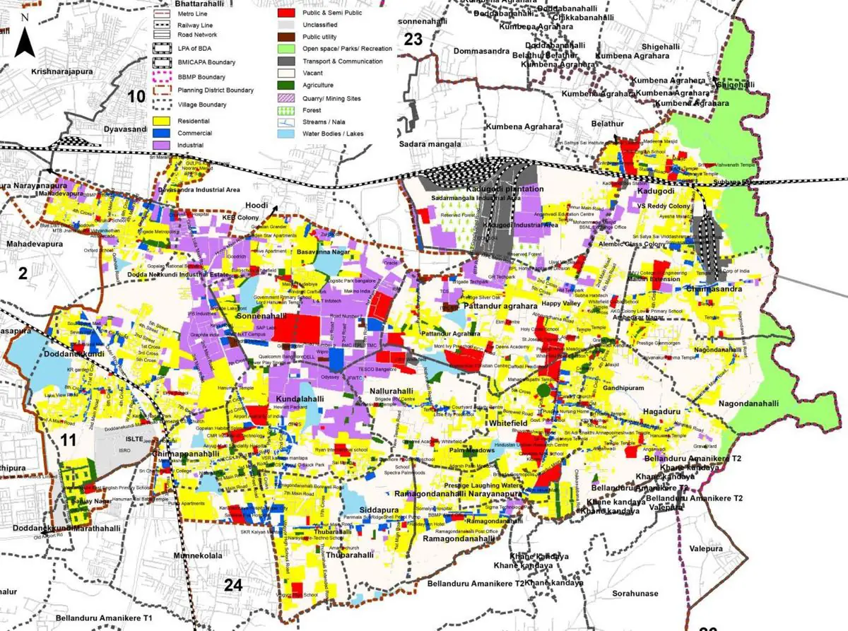
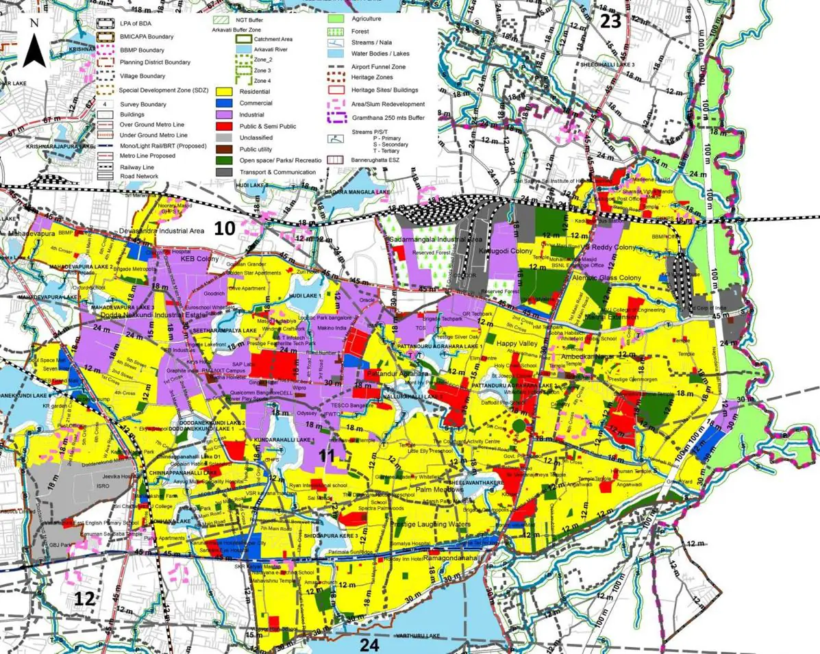
The Existing Land Use Map and Proposed Land Use Map for this PD are in the Planning District Report (PDF). Open the document and go to this PD’s section; use the List of Figures to find “PD 11 Existing Land Use Map” and “PD 11 Proposed Land Use Map”.
| Land use Category | Area (in Ha) | Percentage to Total Area (%) |
|---|---|---|
| Residential | 954.91 | 22.53 |
| Commercial | 116.98 | 2.76 |
| Industrial | 381.03 | 8.99 |
| Quarry/ Mining Sites | 0.00 | 0.00 |
| Public & Semi Public | 177.17 | 4.18 |
| Unclassified | 0.00 | 0.00 |
| Public Utility | 0.00 | 0.00 |
| Parks & Open Spaces | 64.85 | 1.53 |
| Transport & Communication | 366.20 | 8.64 |
| Vacant | 1938.24 | 45.73 |
| Agriculture | 0.00 | 0.00 |
| Forest | 0.00 | 0.00 |
| Streams | 0.00 | 0.00 |
| Water Bodies | 128.00 | 3.02 |
| NGT Buffer | 0.00 | 0.00 |
| Other | 111.02 | 2.62 |
| Total | 4238.40 | 100.00 |
| Land use Category | Area (in Ha) | Percentage To Total Developable Area (%) |
|---|---|---|
| Residential | 1869.80 | 44.12 |
| Commercial | 99.60 | 2.35 |
| Industrial | 545.48 | 12.87 |
| Quarry/ Mining Sites | 0.00 | 0.00 |
| Public & Semi Public | 206.00 | 4.86 |
| Unclassified | 0.00 | 0.00 |
| Public Utility | 0.00 | 0.00 |
| Parks & Open Spaces | 173.77 | 4.10 |
| Transport & Communication | 633.66 | 14.95 |
| Vacant | 0.00 | 0.00 |
| Agriculture | 0.00 | 0.00 |
| Forest | 0.00 | 0.00 |
| Streams | 0.00 | 0.00 |
| Water Bodies | 135.00 | 3.19 |
| NGT Buffer | 385.70 | 9.10 |
| Other | 188.19 | 4.44 |
| Total Developable Area | 4237.20 | , |
Total PD Area 4238.40 Ha. Source: Revised Master Plan 2031 (Draft) Volume-4.
Road Development Plan, Public Transport System, Multimodal Interchange Stations, Parks and Open Spaces, Protection and Rejuvenation of Lakes and Streams, Area Redevelopment, Heritage Area Protection and Conservation, Physical Infrastructure, Disaster Mitigation.