Demography
Population (2011)
197,982
Census 2011
Area
3867.3 Ha
38.67 sq.km
Gross Density
51 PPH
Persons per Hectare
Wards/Villages
5
Within BBMP
Major employment centre. HAL, NAL, ISRO, Embassy Tech Village, RMZ Eco Space. Bellandur Lake and series of lakes. ORR tech zone highly vulnerable to flooding. 87.79% decadal growth.
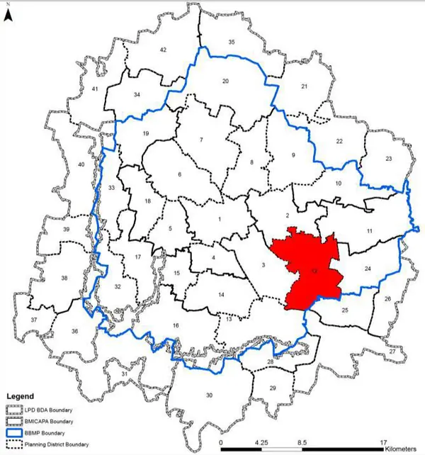
1. Planning District consists of the wards four BBMP wards, namely - Bellandur (150), Marathalli (86), Konena Agrahara (113) and Hal Airport (87) and admeasures 3867.3 Ha.
2. It houses several defence establishments – like HAL, NAL, ISRO, and number of IT/ ITES/ Aerospace Companies in number tech parks like Embassy Tech Village, RMZ Eco Space, Prestige Tech Park, Embassy Golf Link Bussiness Park, Divyashree Technopolis, Cessna Business Park and standalone large campuses – like that of Intel and Wipro as well as Independent Office Buildings where lakhs of people are employed. The residential developments are mostly of high density and unplanned in nature with the dense pockets, plotted developments and high rise buildings. However, there are under served settlement pockets as well. Bellandur kere and series of lake define the drainage pattern of planning district; however the valley system has been disturbed due to urbanisation making ORR tech zone highly vulnerable to flooding. At the same time, PD still has potential for futher growth to accommodate additional employment and population, which may further compound the local level problems.
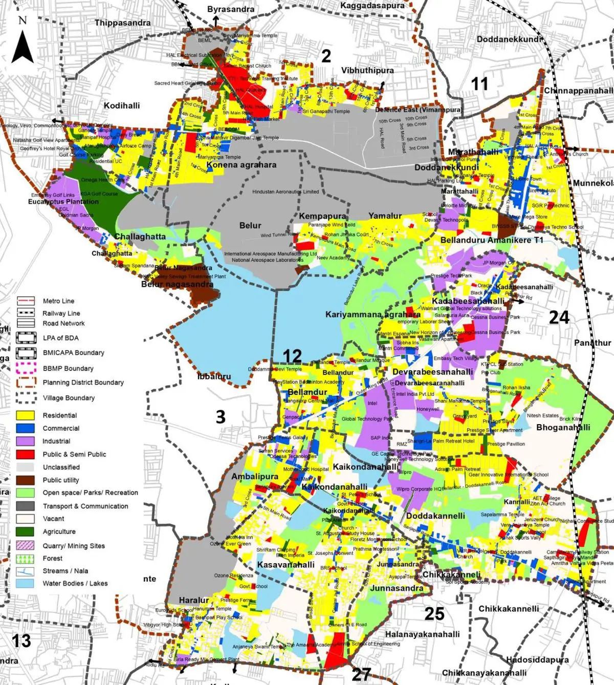
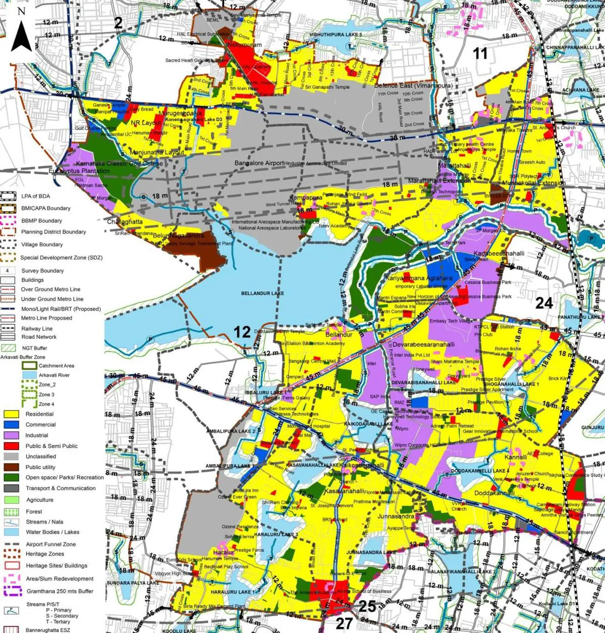
The Existing Land Use Map and Proposed Land Use Map for this PD are in the Planning District Report (PDF). Open the document and go to this PD’s section; use the List of Figures to find “PD 12 Existing Land Use Map” and “PD 12 Proposed Land Use Map”.
| Land use Category | Area (in Ha) | Percentage to Total Area (%) |
|---|---|---|
| Residential | 786.22 | 20.33 |
| Commercial | 119.89 | 3.10 |
| Industrial | 206.13 | 5.33 |
| Quarry/ Mining Sites | 0.00 | 0.00 |
| Public & Semi Public | 101.71 | 2.63 |
| Unclassified | 0.00 | 0.00 |
| Public Utility | 0.00 | 0.00 |
| Parks & Open Spaces | 90.49 | 2.34 |
| Transport & Communication | 188.72 | 4.88 |
| Vacant | 1246.23 | 32.22 |
| Agriculture | 0.00 | 0.00 |
| Forest | 0.00 | 0.00 |
| Streams | 0.00 | 0.00 |
| Water Bodies | 384.02 | 9.93 |
| NGT Buffer | 0.00 | 0.00 |
| Other | 743.19 | 19.22 |
| Total | 3867.30 | 100.00 |
| Land use Category | Area (in Ha) | Percentage To Total Developable Area (%) |
|---|---|---|
| Residential | 1461.25 | 37.78 |
| Commercial | 75.80 | 1.96 |
| Industrial | 269.94 | 6.98 |
| Quarry/ Mining Sites | 0.00 | 0.00 |
| Public & Semi Public | 117.57 | 3.04 |
| Unclassified | 0.00 | 0.00 |
| Public Utility | 0.00 | 0.00 |
| Parks & Open Spaces | 175.19 | 4.53 |
| Transport & Communication | 230.88 | 5.97 |
| Vacant | 0.00 | 0.00 |
| Agriculture | 0.00 | 0.00 |
| Forest | 0.00 | 0.00 |
| Streams | 0.00 | 0.00 |
| Water Bodies | 368.17 | 9.52 |
| NGT Buffer | 418.26 | 10.82 |
| Other | 750.24 | 19.40 |
| Total Developable Area | 3867.30 | , |
Total PD Area 3867.30 Ha. Source: Revised Master Plan 2031 (Draft) Volume-4.
Road Development Plan, Public Transport System, Multimodal Interchange Stations, Parks and Open Spaces, Protection and Rejuvenation of Lakes and Streams, Area Redevelopment, Heritage Area Protection and Conservation, Physical Infrastructure, Disaster Mitigation.