Demography
Population (2011)
343,840
Census 2011
Area
3356.4 Ha
33.56 sq.km
Gross Density
102 PPH
Persons per Hectare
Wards/Villages
5
Within BBMP
South-Southeast BBMP. 196% decadal growth - highest among PDs. 21 lakes, IIM, Meenakshi Mall, Central Jail. Garment factories, IT/ITES along Hosur and Bannerughatta Roads. 13.3% metered water, 8.5% sewage connections.
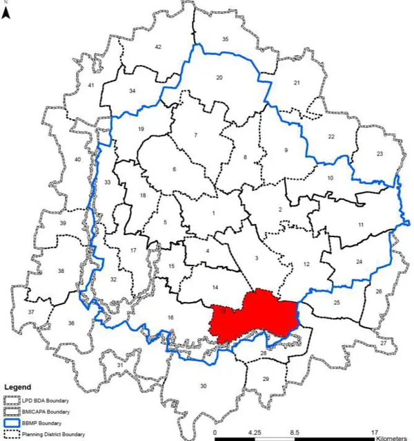
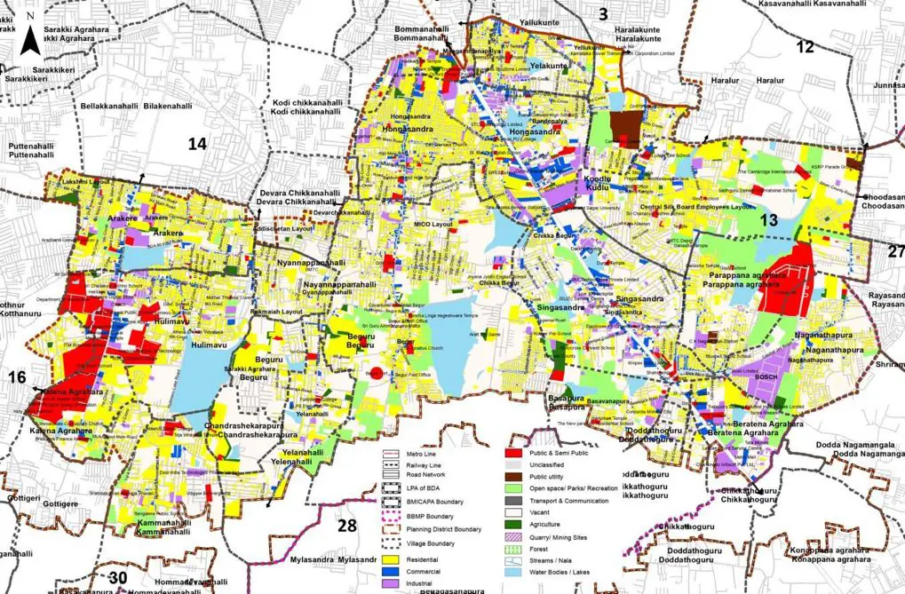
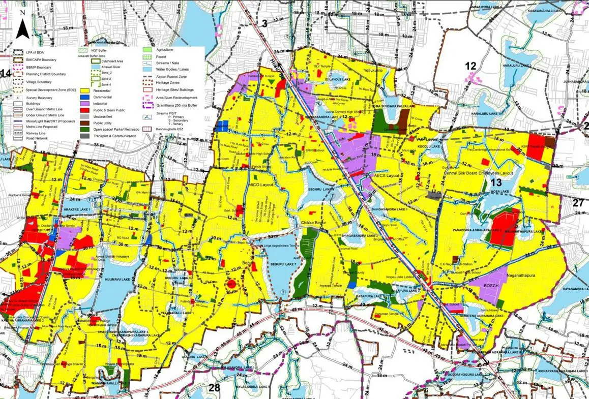
1. The Parappana Agrahara – Hulimavur Planning District comprises of 5 wards, - Hongasandra (189), Managammanapalya (190), Singasandra (191), Begur (192) and Arakere (193) and falls within the Bommanahalli zone of BBMP. The total extent of PD is approximately 3356 ha.
2. Parappana Agrahara – Hulimavur Planning District (PD No.12) is located South - South East in BBMP and shares its southern boundary with LPA of BMICAPA. It is spatially stretched from Central Jail (Hosur Road) till IIM (Bannerughatta Road), and houses several industries, garment factories, IT Companies commercial establishments, and higher order educational institutes like IIM. The presence of 21 Lakes, fully commercialized radial roads, highly strained arterial road network and combination of planned as well as haphazard residential areas defines the characterics of PD. Major Landmarks within the PD are Meenakshi temple, Meenakshi Mall, Oxford College, Kudlu gate and Bangalore Central jail.
The Existing Land Use Map and Proposed Land Use Map for this PD are in the Planning District Report (PDF). Open the document and go to this PD’s section; use the List of Figures to find “PD 13 Existing Land Use Map” and “PD 13 Proposed Land Use Map”.
| Land use Category | Area (in Ha) | Percentage to Total Area (%) |
|---|---|---|
| Residential | 895.51 | 26.68 |
| Commercial | 132.24 | 3.94 |
| Industrial | 139.62 | 4.16 |
| Quarry/ Mining Sites | 0.00 | 0.00 |
| Public & Semi Public | 174.20 | 5.19 |
| Unclassified | 0.00 | 0.00 |
| Public Utility | 0.00 | 0.00 |
| Parks & Open Spaces | 35.91 | 1.07 |
| Transport & Communication | 282.94 | 8.43 |
| Vacant | 1480.56 | 44.11 |
| Agriculture | 0.00 | 0.00 |
| Forest | 0.00 | 0.00 |
| Streams | 0.00 | 0.00 |
| Water Bodies | 194.00 | 5.78 |
| NGT Buffer | 0.00 | 0.00 |
| Other | 20.48 | 0.61 |
| Total | 3356.36 | 100.00 |
| Land use Category | Area (in Ha) | Percentage To Total Developable Area (%) |
|---|---|---|
| Residential | 1913.40 | 57.01 |
| Commercial | 51.69 | 1.54 |
| Industrial | 103.38 | 3.08 |
| Quarry/ Mining Sites | 0.00 | 0.00 |
| Public & Semi Public | 145.67 | 4.34 |
| Unclassified | 0.00 | 0.00 |
| Public Utility | 0.00 | 0.00 |
| Parks & Open Spaces | 87.27 | 2.60 |
| Transport & Communication | 417.73 | 12.45 |
| Vacant | 0.00 | 0.00 |
| Agriculture | 0.00 | 0.00 |
| Forest | 0.00 | 0.00 |
| Streams | 0.00 | 0.00 |
| Water Bodies | 188.29 | 5.61 |
| NGT Buffer | 432.54 | 12.89 |
| Other | 0.00 | 0.00 |
| Total Developable Area | 3339.97 | , |
Total PD Area 3356.36 Ha. Source: Revised Master Plan 2031 (Draft) Volume-4.
Road Development Plan, Public Transport System, Multimodal Interchange Stations, Parks and Open Spaces, Protection and Rejuvenation of Lakes and Streams, Area Redevelopment, Heritage Area Protection and Conservation, Physical Infrastructure, Disaster Mitigation.