Demography
Population (2011)
636,202
Census 2011
Area
2721.1 Ha
27.21 sq.km
Gross Density
234 PPH
Persons per Hectare
Wards/Villages
16
Within BBMP
South central BBMP. Planned residential BDA schemes: Jayanagar, BTM Layout, JP Nagar, Kumaraswamy Layout, Banashankari. IIM, Jayadeva Institute, Dayanand Sagar. 37% decadal growth. 44.2% metered water, 26.67% sewage. Flood-prone: Kuvempu Nagar, Kodichekkenahalli, JP Nagar 6th Stage, Yelachenahalli.
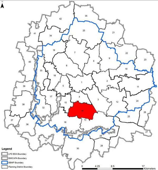
1. The Banashankari – BTM – Madivala PD comprises of 16 wards, - comprises of 16 BBMP wards – namely Karisandra (166), Pattabhiram Nagar (168), Jayanagar East (170), Gurappanapalya (171), Madiwala (172), BTM Layout (176), J.P.Nagar (177), Sarakki (178), Shakambari Nagar(179), Banashankari Temple Ward (180), Kumaraswamy Layout (181) falling within the South Zone of the BBMP and Bommanahalli (175), Yelachenahalli(185), Jaraganahalli (186), Puttenahalli (187), Bilekahalli (188) falling within the Bommanahalli zone of BBMP and admeasures 2721 ha (27.21 sqkm). It stretches from Hosur Road to Kanakapura Road (east and west), and Jayanagar 7th Block (on North) and IIM (on southern side).
2. The plannned large residential BDA schemes like Jayanagar, BTM Layout, JP Nagar, Kumarsawamy Layout, Banashankari, highly dense areas of Bommanahalli, Illiyas Nagar, Kadarenahalli, higher eduction insitutes like - Indian Institute of Management (IIM), Jayadeva Institute of Cardiovascular Sciences and Research, Dayanand Sagar College, Power Tranining Institute, the availabllity of quality healthcare and social facilities like – playgrounds, parks, auditoriums, etc, rapid commercialisation of planned residential areas, private industrial estates, and IT/ ITES as well as Garment Industires, the 7th century old Banshankari temple and two important lakes – Madivala and Sarakee Kere define the characteristics of this vibrant PD.
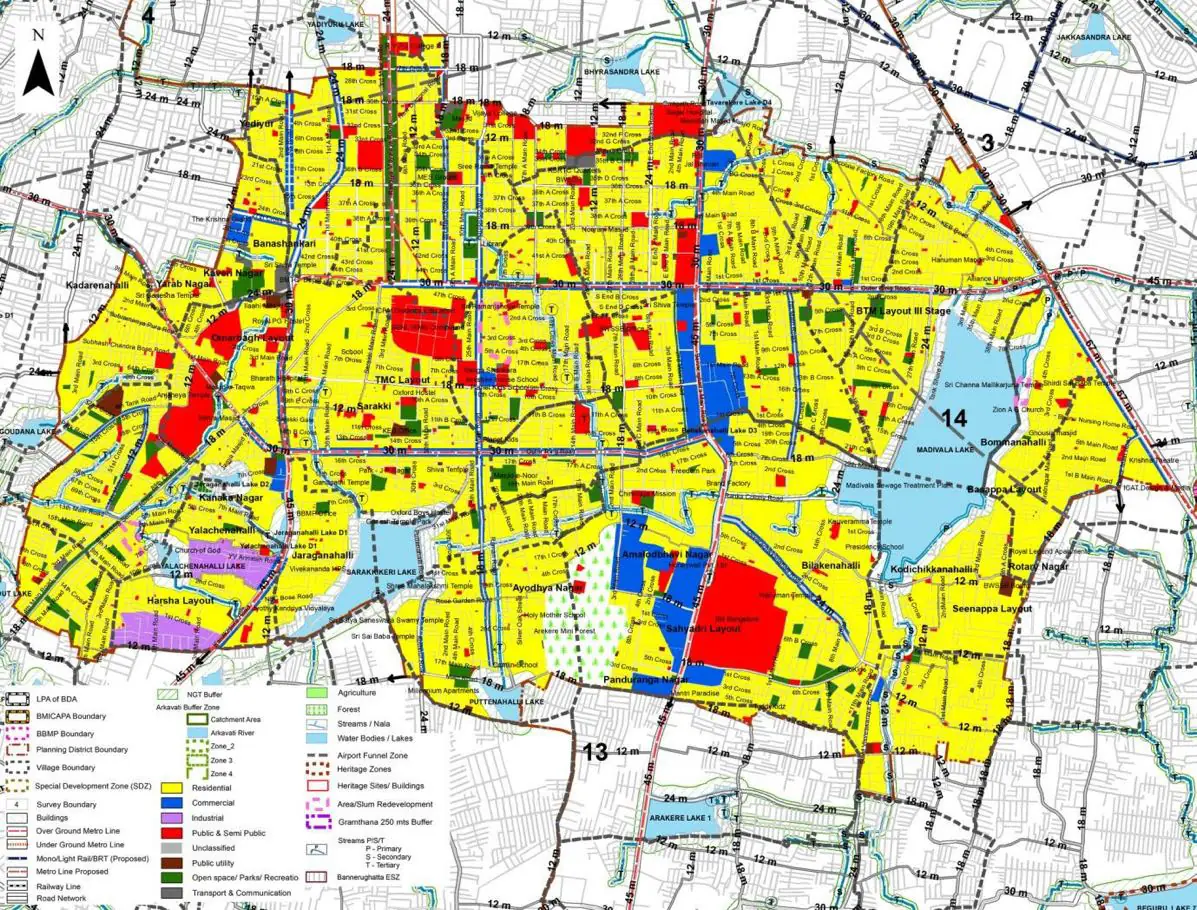
The Existing Land Use Map and Proposed Land Use Map for this PD are in the Planning District Report (PDF). Open the document and go to this PD’s section; use the List of Figures to find “PD 14 Existing Land Use Map” and “PD 14 Proposed Land Use Map”.
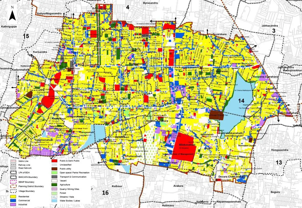
| Land use Category | Area (in Ha) | Percentage to Total Area (%) |
|---|---|---|
| Residential | 1242.04 | 45.64 |
| Commercial | 232.21 | 8.53 |
| Industrial | 81.09 | 2.98 |
| Quarry/ Mining Sites | 0.00 | 0.00 |
| Public & Semi Public | 169.53 | 6.23 |
| Unclassified | 0.00 | 0.00 |
| Public Utility | 0.00 | 0.00 |
| Parks & Open Spaces | 86.53 | 3.18 |
| Transport & Communication | 395.92 | 14.55 |
| Vacant | 327.90 | 12.05 |
| Agriculture | 0.00 | 0.00 |
| Forest | 41.63 | 1.53 |
| Streams | 0.00 | 0.00 |
| Water Bodies | 115.65 | 4.25 |
| NGT Buffer | 0.00 | 0.00 |
| Other | 8.98 | 0.33 |
| Total | 2721.12 | 100.00 |
| Land use Category | Area (in Ha) | Percentage To Total Developable Area (%) |
|---|---|---|
| Residential | 1470.99 | 54.06 |
| Commercial | 126.26 | 4.64 |
| Industrial | 24.49 | 0.90 |
| Quarry/ Mining Sites | 0.00 | 0.00 |
| Public & Semi Public | 173.61 | 6.38 |
| Unclassified | 0.00 | 0.00 |
| Public Utility | 0.00 | 0.00 |
| Parks & Open Spaces | 74.01 | 2.72 |
| Transport & Communication | 438.64 | 16.12 |
| Vacant | 0.00 | 0.00 |
| Agriculture | 0.00 | 0.00 |
| Forest | 41.09 | 1.51 |
| Streams | 0.00 | 0.00 |
| Water Bodies | 115.10 | 4.23 |
| NGT Buffer | 236.74 | 8.70 |
| Other | 8.71 | 0.32 |
| Total Developable Area | 2709.64 | , |
Total PD Area 2721.12 Ha. Source: Revised Master Plan 2031 (Draft) Volume-4.
Road Development Plan, Public Transport System, Multimodal Interchange Stations, Parks and Open Spaces, Protection and Rejuvenation of Lakes and Streams, Area Redevelopment, Heritage Area Protection and Conservation, Physical Infrastructure, Disaster Mitigation.