Demography
Population (2011)
421,179
Census 2011
Area
1324.5 Ha
13.24 sq.km
Gross Density
318 PPH
Persons per Hectare
Wards/Villages
9
Within BBMP
Central South West BBMP. Dense residential (Banashankari 1st/3rd stage, Katriguppe, Padmanabhanagar, Girinagar). 44.34% decadal growth. Vrushabhavati River passes west. 50% water, 26.9% sewage. 12 DWCCs, 1 OWCC.
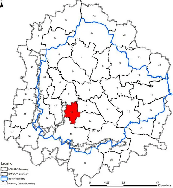
Gross Density (2011 Census): 320 pph Kathriguppe Planning District (PD No15) is located in the Central South West in BBMP and shares its western boundary with LPA of BMICAPA. It is characterised by dense residential areas as well commercialised road network. The PD currently is in transition from being predominantly a residential to a mixed use zone with commercialization seen along all major roads. Revised Master Plan 2031 aims at stabilising the transformation by limiting commercial activities to on certain roads and planned redevelopment of certain areas.
1. The Kathriguppe planning district comprises of 9 wards and a part of Vasanthpura ward (ward is partly under jurisdiction of LPA of BMICAPA). The 9 wards of BBMP include Hosakerehalli (161), Chikkalasandra (183), Padmanabha Nagar (182), Katriguppe (163), Vidyapeetha (164), Giri Nagar (162), Sri Nagar (156), Ganeshmandira Ward (165), Hanumantha Nagar (155). PD admeasures around 1324 ha.
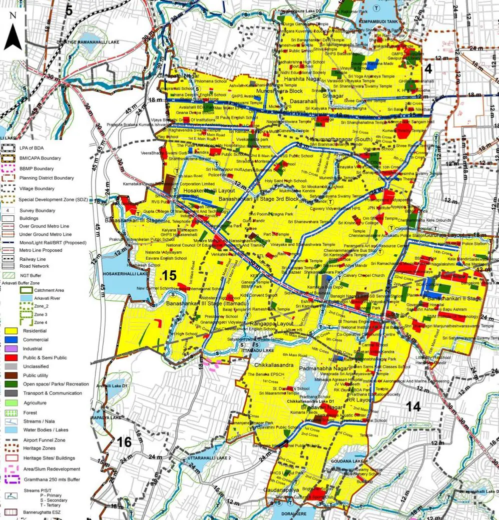
The Existing Land Use Map and Proposed Land Use Map for this PD are in the Planning District Report (PDF). Open the document and go to this PD’s section; use the List of Figures to find “PD 15 Existing Land Use Map” and “PD 15 Proposed Land Use Map”.
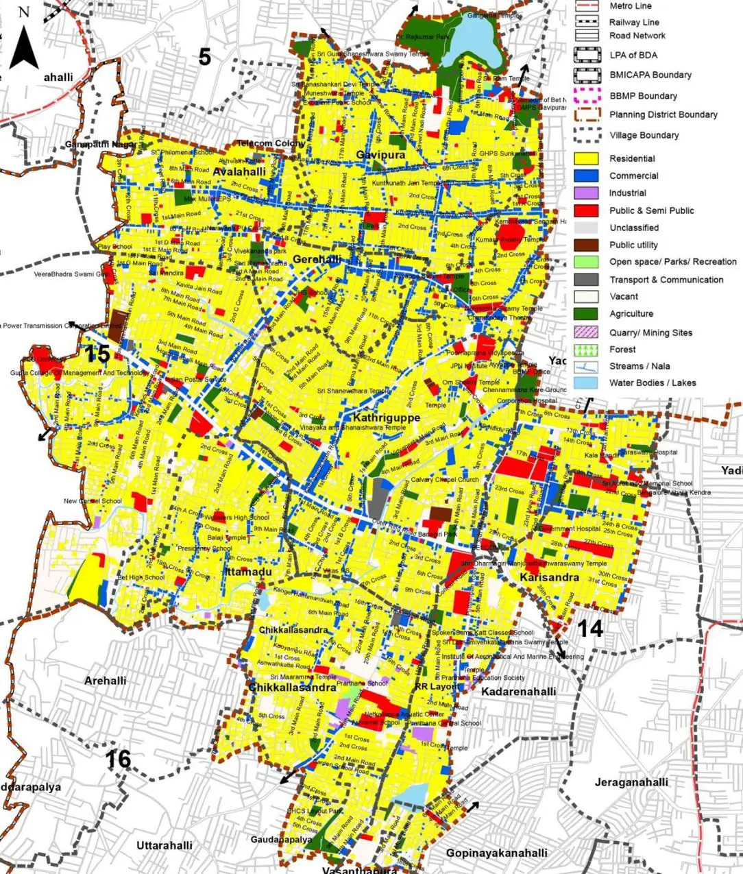
| Land use Category | Area (in Ha) | Percentage to Total Area (%) |
|---|---|---|
| Residential | 725.30 | 54.76 |
| Commercial | 100.39 | 7.58 |
| Industrial | 6.75 | 0.51 |
| Quarry/ Mining Sites | 0.00 | 0.00 |
| Public & Semi Public | 59.73 | 4.51 |
| Unclassified | 0.00 | 0.00 |
| Public Utility | 0.00 | 0.00 |
| Parks & Open Spaces | 44.01 | 3.32 |
| Transport & Communication | 218.27 | 16.48 |
| Vacant | 144.29 | 10.89 |
| Agriculture | 0.00 | 0.00 |
| Forest | 0.00 | 0.00 |
| Streams | 0.00 | 0.00 |
| Water Bodies | 12.45 | 0.94 |
| NGT Buffer | 0.00 | 0.00 |
| Other | 9.14 | 0.69 |
| Total | 1324.46 | 100.00 |
| Land use Category | Area (in Ha) | Percentage To Total Developable Area (%) |
|---|---|---|
| Residential | 797.53 | 60.22 |
| Commercial | 44.37 | 3.35 |
| Industrial | 0.00 | 0.00 |
| Quarry/ Mining Sites | 0.00 | 0.00 |
| Public & Semi Public | 52.71 | 3.98 |
| Unclassified | 0.00 | 0.00 |
| Public Utility | 0.00 | 0.00 |
| Parks & Open Spaces | 29.97 | 2.26 |
| Transport & Communication | 237.08 | 17.90 |
| Vacant | 0.00 | 0.00 |
| Agriculture | 0.00 | 0.00 |
| Forest | 0.00 | 0.00 |
| Streams | 0.00 | 0.00 |
| Water Bodies | 12.45 | 0.94 |
| NGT Buffer | 137.15 | 10.36 |
| Other | 8.48 | 0.64 |
| Total Developable Area | 1319.74 | , |
Total PD Area 1324.46 Ha. Source: Revised Master Plan 2031 (Draft) Volume-4.
Road Development Plan, Public Transport System, Multimodal Interchange Stations, Parks and Open Spaces, Protection and Rejuvenation of Lakes and Streams, Area Redevelopment, Heritage Area Protection and Conservation, Physical Infrastructure, Disaster Mitigation.