Demography
Population (2011)
272,629
Census 2011
Area
4022.9 Ha
40.23 sq.km
Gross Density
68 PPH
Persons per Hectare
Wards/Villages
6
Within BBMP
Southern BMA. J.P. Nagar 7th/8th phase, Uttarahalli, Anjanapura, Banashankari 6th Stage. Turahalli Reserved Forest (4.46 sq.km). 141.75% decadal growth. 16.61% water, 11.85% sewage. 183 schools, 15 hospitals.
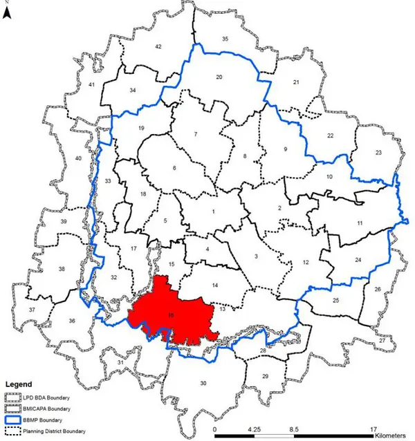
The Planning District 16 is located at southern quadrant of the BMA planning area. It is characterised with residential areas of Gottigere, Uttrahalli, J.P.nagar 7th phase, Anjanapura Layout, Banashankari 6th stage etc. It is characterised by the Turahalli Reserved Forest. The Revised Master Plan 2031 proposes densification of the residential areas in a planned manner along with increased public transport share and other transit integration and infrastructure upgradation
1. The Gottigere – Anjanapura PD extent measures 4022 ha (40.22 sq,km.) and comprises of 6 wards,- namely Uttarahalli (184), Gottigere (part with BMICAPA) (194), Konanakunte (195), Anjanapura (part BMICAPA) (196), Vasanthapura (197), Hemmigepura (part BMICAPA) (198) and covers the Bommanahalli Zone and Rajarajeshwari Zone of BBMP. Additionally only a small part of the ward Rajarajeshwari (160) falls under this PD.
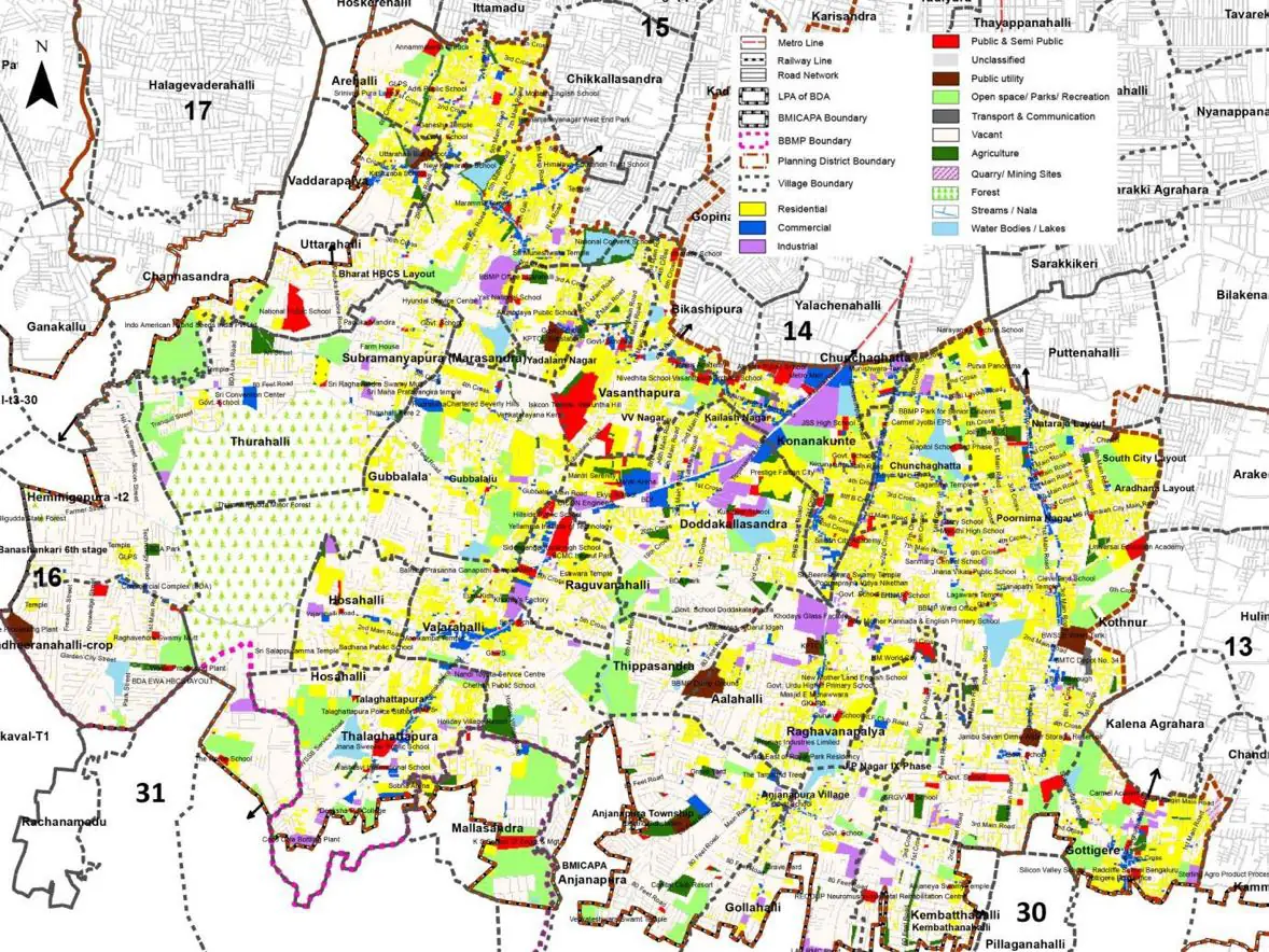
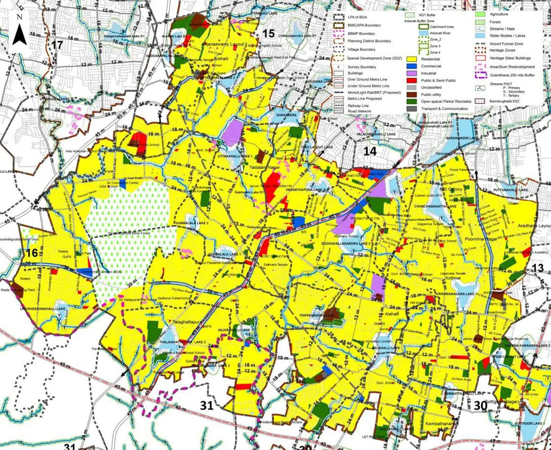
The Existing Land Use Map and Proposed Land Use Map for this PD are in the Planning District Report (PDF). Open the document and go to this PD’s section; use the List of Figures to find “PD 16 Existing Land Use Map” and “PD 16 Proposed Land Use Map”.
| Land use Category | Area (in Ha) | Percentage to Total Area (%) |
|---|---|---|
| Residential | 782.46 | 19.45 |
| Commercial | 99.37 | 2.47 |
| Industrial | 101.38 | 2.52 |
| Quarry/ Mining Sites | 0.00 | 0.00 |
| Public & Semi Public | 84.88 | 2.11 |
| Unclassified | 0.00 | 0.00 |
| Public Utility | 0.00 | 0.00 |
| Parks & Open Spaces | 74.83 | 1.86 |
| Transport & Communication | 368.10 | 9.15 |
| Vacant | 2158.09 | 53.64 |
| Agriculture | 0.00 | 0.00 |
| Forest | 244.19 | 6.07 |
| Streams | 0.00 | 0.00 |
| Water Bodies | 70.80 | 1.76 |
| NGT Buffer | 0.00 | 0.00 |
| Other | 10.06 | 0.25 |
| Total | 4022.93 | 100.00 |
| Land use Category | Area (in Ha) | Percentage To Total Developable Area (%) |
|---|---|---|
| Residential | 2452.77 | 60.97 |
| Commercial | 50.29 | 1.25 |
| Industrial | 45.86 | 1.14 |
| Quarry/ Mining Sites | 0.00 | 0.00 |
| Public & Semi Public | 74.02 | 1.84 |
| Unclassified | 0.00 | 0.00 |
| Public Utility | 0.00 | 0.00 |
| Parks & Open Spaces | 140.80 | 3.50 |
| Transport & Communication | 500.25 | 12.43 |
| Vacant | 0.00 | 0.00 |
| Agriculture | 0.00 | 0.00 |
| Forest | 235.34 | 5.85 |
| Streams | 0.00 | 0.00 |
| Water Bodies | 71.61 | 1.78 |
| NGT Buffer | 410.34 | 10.20 |
| Other | 9.66 | 0.24 |
| Total Developable Area | 3990.94 | , |
Total PD Area 4022.93 Ha. Source: Revised Master Plan 2031 (Draft) Volume-4.
Road Development Plan, Public Transport System, Multimodal Interchange Stations, Parks and Open Spaces, Protection and Rejuvenation of Lakes and Streams, Area Redevelopment, Heritage Area Protection and Conservation, Physical Infrastructure, Disaster Mitigation.