Demography
Population (2011)
23,314
Census 2011
Area
3216.9 Ha
32.17 sq.km
Gross Density
7 PPH
Persons per Hectare
Wards/Villages
13
Outside BBMP
North-east BMA between Dodda Gubbi and Old Madras Road. Yelemallapa Chetty lake series. 66.30% decadal growth. No metered water/sewage. 27 schools; East Point Engineering College, Garden City College, Indus Valley Residential School.
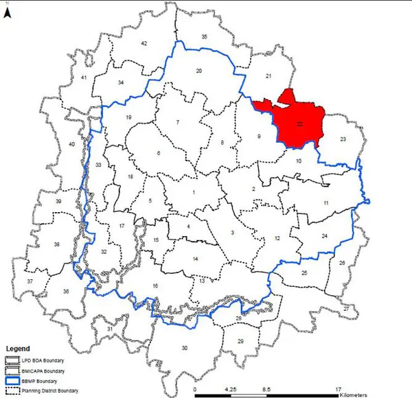
Gramthana in PD: 13 Bidarahalli Planning District (PD 22) is located in the north-eastern side of BMA planning area between Dodda Gubbi Main Road and Old Madras Road. This PD shares boundary with tehHoskote LPA. Revised Master Plan 2031 proposes growth along the PRR and preservation of Agriculture Zone.
1. The PD falls completely within Bidarahalli Hobli. The PD comprises of 13 villages namely Kada Agrahara, Anagalapura, Byappanahalli, Vaddarahalli, Adooru, Bidarahalli, Ramapura, Huvina Ane, Maragondanahalli, Kithaganooru, Hale halli, Hirandahalli, Doddagubbi (Srigubbi).
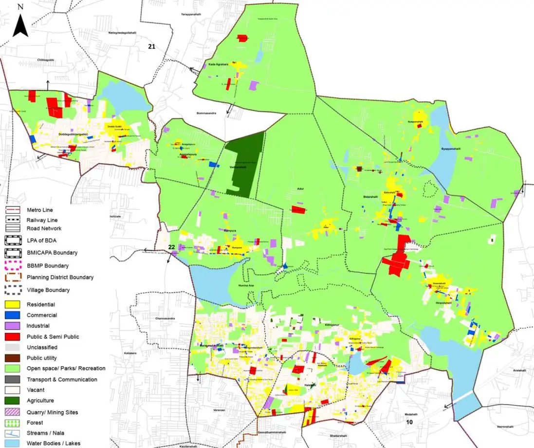
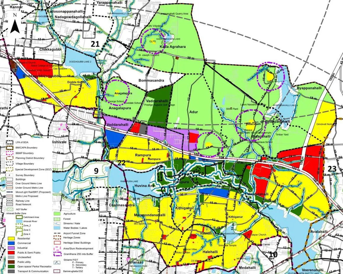
The Existing Land Use Map and Proposed Land Use Map for this PD are in the Planning District Report (PDF). Open the document and go to this PD’s section; use the List of Figures to find “PD 22 Existing Land Use Map” and “PD 22 Proposed Land Use Map”.
| Land use Category | Area (in Ha) | Percentage to Total Area (%) |
|---|---|---|
| Residential | 169.53 | 5.27 |
| Commercial | 15.12 | 0.47 |
| Industrial | 35.39 | 1.10 |
| Quarry/ Mining Sites | 0.00 | 0.00 |
| Public & Semi Public | 53.40 | 1.66 |
| Unclassified | 0.00 | 0.00 |
| Public Utility | 0.00 | 0.00 |
| Parks & Open Spaces | 44.72 | 1.39 |
| Transport & Communication | 128.03 | 3.98 |
| Vacant | 777.21 | 24.16 |
| Agriculture | 1759.35 | 54.69 |
| Forest | 0.00 | 0.00 |
| Streams | 0.00 | 0.00 |
| Water Bodies | 194.62 | 6.05 |
| NGT Buffer | 0.00 | 0.00 |
| Other | 9.33 | 0.29 |
| Total | 3216.94 | 100.00 |
| Land use Category | Area (in Ha) | Percentage To Total Developable Area (%) |
|---|---|---|
| Residential | 1368.49 | 42.54 |
| Commercial | 67.23 | 2.09 |
| Industrial | 100.37 | 3.12 |
| Quarry/ Mining Sites | 0.00 | 0.00 |
| Public & Semi Public | 251.56 | 7.82 |
| Unclassified | 0.00 | 0.00 |
| Public Utility | 0.00 | 0.00 |
| Parks & Open Spaces | 269.90 | 8.39 |
| Transport & Communication | 469.03 | 14.58 |
| Vacant | 0.00 | 0.00 |
| Agriculture | 0.00 | 0.00 |
| Forest | 0.00 | 0.00 |
| Streams | 0.00 | 0.00 |
| Water Bodies | 196.11 | 6.10 |
| NGT Buffer | 476.11 | 14.80 |
| Other | 11.58 | 0.36 |
| Total Developable Area | 3210.38 | , |
Total PD Area 3216.94 Ha. Source: Revised Master Plan 2031 (Draft) Volume-4.
Road Development Plan, Public Transport System, Multimodal Interchange Stations, Parks and Open Spaces, Protection and Rejuvenation of Lakes and Streams, Area Redevelopment, Heritage Area Protection and Conservation, Physical Infrastructure, Disaster Mitigation.