Demography
Population (2011)
39,377
Census 2011
Area
2729.4 Ha
27.29 sq.km
Gross Density
14 PPH
Persons per Hectare
Wards/Villages
18
Outside BBMP
North-East BMA between OMR and Whitefield Main Road. 82.84% decadal growth. Cheemasandra and Virgonagar industrial (food, glass, manufacturing). High rise along OMR. 17 schools. PRR triggers development.
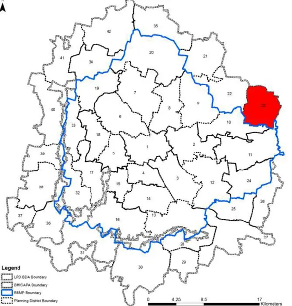
ZONE Villages in PD: 17 Gross Density: 14.4 pph Cheemasandra Planning District (PD No. 23) is located in the North- Eastern side of BMA between Old Madras Road (NH4) and Whitefield Main road. It is characterised predominantly by existing agricultural use, large tracts of vacant land and industrial activity at Cheemasandra. PD boundary is shared with LPA of Hoskote Planning Authority. The Revised Master Plan 2031 proposes development of special development zone promoting high density planned employment centres and residential development.
1. The Planning District comprises of 17 villages namely Veeranahalli, Kurudasonnenahalli, Cheemasandra, Katamnalluru, Bhanadapura, Konadasapura, Goravigere, Bidare Agraharavu Chikkanagenahalli, Doddabanahalli, Kannamangala, Dommasandra, Chikkabanahalli, Sheegihalli, Nimbekayipura, Avalahalli, Kumbena Agrahara and Kajisonnenahalli.
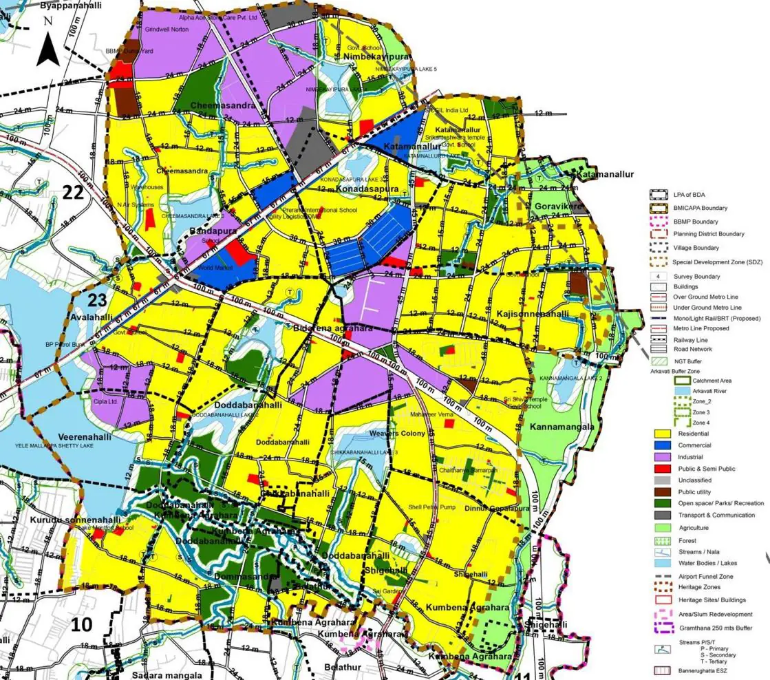
The Existing Land Use Map and Proposed Land Use Map for this PD are in the Planning District Report (PDF). Open the document and go to this PD’s section; use the List of Figures to find “PD 23 Existing Land Use Map” and “PD 23 Proposed Land Use Map”.
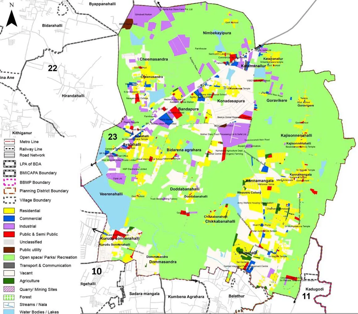
| Land use Category | Area (in Ha) | Percentage to Total Area (%) |
|---|---|---|
| Residential | 280.86 | 10.29 |
| Commercial | 30.02 | 1.10 |
| Industrial | 154.76 | 5.67 |
| Quarry/ Mining Sites | 0.00 | 0.00 |
| Public & Semi Public | 33.84 | 1.24 |
| Unclassified | 0.00 | 0.00 |
| Public Utility | 0.00 | 0.00 |
| Parks & Open Spaces | 16.90 | 0.62 |
| Transport & Communication | 96.89 | 3.55 |
| Vacant | 526.20 | 19.28 |
| Agriculture | 1452.85 | 53.23 |
| Forest | 0.00 | 0.00 |
| Streams | 0.00 | 0.00 |
| Water Bodies | 124.73 | 4.57 |
| NGT Buffer | 0.00 | 0.00 |
| Other | 33.80 | 1.24 |
| Total | 2729.41 | 100.00 |
| Land use Category | Area (in Ha) | Percentage To Total Developable Area (%) |
|---|---|---|
| Residential | 1270.09 | 46.53 |
| Commercial | 75.54 | 2.77 |
| Industrial | 278.57 | 10.21 |
| Quarry/ Mining Sites | 0.00 | 0.00 |
| Public & Semi Public | 34.66 | 1.27 |
| Unclassified | 0.00 | 0.00 |
| Public Utility | 0.00 | 0.00 |
| Parks & Open Spaces | 166.49 | 6.10 |
| Transport & Communication | 397.13 | 14.55 |
| Vacant | 0.00 | 0.00 |
| Agriculture | 0.00 | 0.00 |
| Forest | 0.00 | 0.00 |
| Streams | 0.00 | 0.00 |
| Water Bodies | 123.37 | 4.52 |
| NGT Buffer | 355.52 | 13.03 |
| Other | 7.37 | 0.27 |
| Total Developable Area | 2708.74 | , |
Total PD Area 2729.41 Ha. Source: Revised Master Plan 2031 (Draft) Volume-4.
Road Development Plan, Public Transport System, Multimodal Interchange Stations, Parks and Open Spaces, Protection and Rejuvenation of Lakes and Streams, Area Redevelopment, Heritage Area Protection and Conservation, Physical Infrastructure, Disaster Mitigation.