Demography
Population (2011)
55,838
Census 2011
Area
2870.2 Ha
28.70 sq.km
Gross Density
19 PPH
Persons per Hectare
Wards/Villages
2
Within BBMP
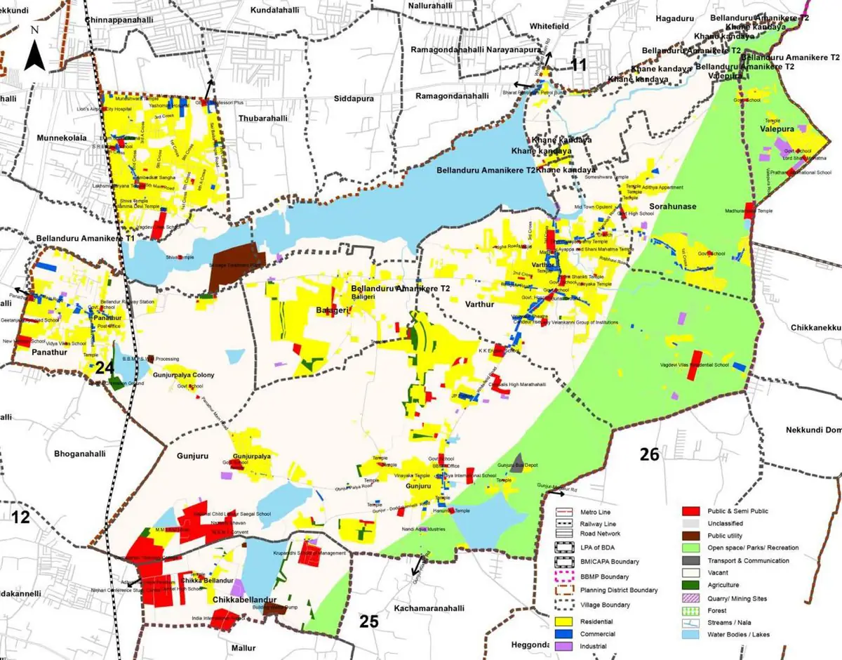
South-east BBMP. Varthur Ward + Valepura village. 115.1% decadal growth. Large vacant (67%). Gramathanas: Varthur, Balagere, Gunjur, Panathur, Madhura Nagar, Sorahunase. 8.6% water, 5.3% sewage. 35 schools, 2 colleges. Bellandur Railway Station.
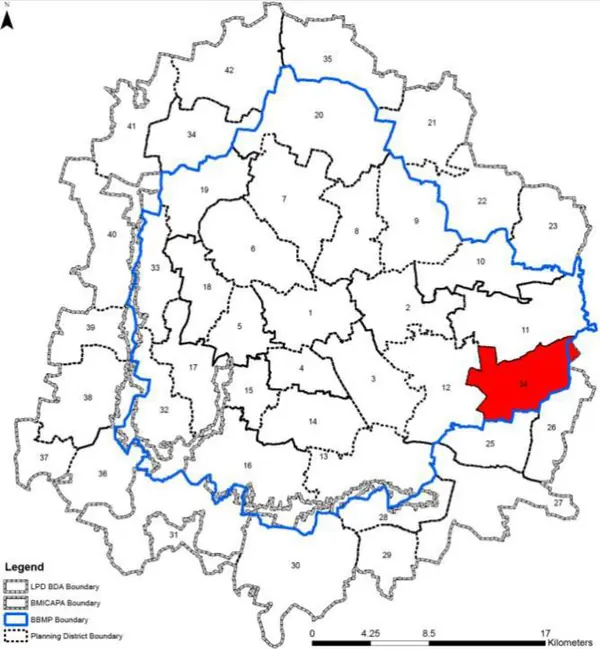
1. Planning District comprises of Varthur Ward of BBMP and Valepura village of Varthur Hobli and admeasures about 2870.20Ha.
2. Old Airport Road/ Varthur Road, SH35, Balagere Road, Panathur Road/ Gunjur Palya Road/ Gunjur-Mugalur Road, Muthasandra Main Road, Halasahalli Cross Road, Munnekollal Main Road are some of the roads forming the connectivity network within the planning district. The Bengaluru – Salem railway line passes through PD with station at Belandur.
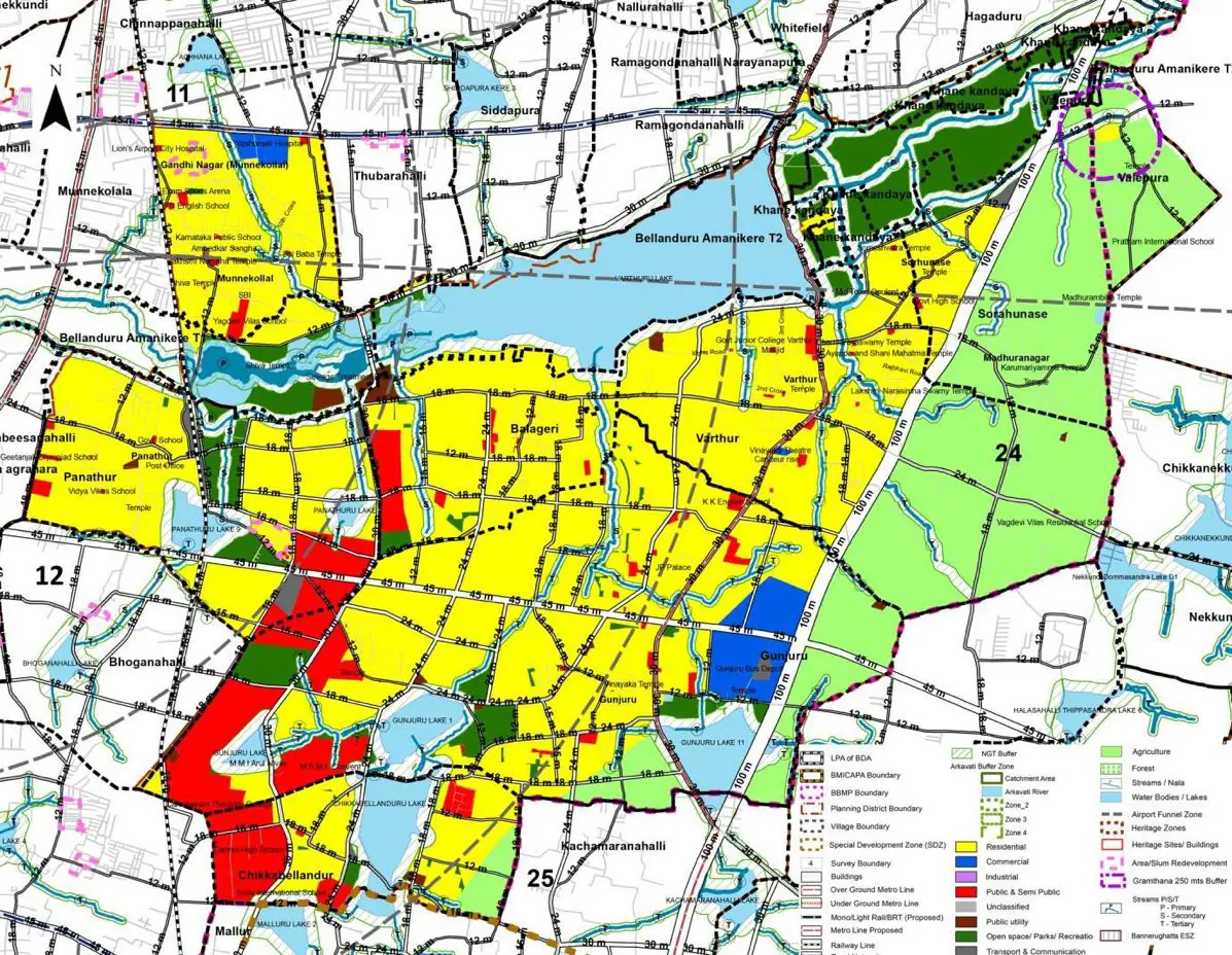
The Existing Land Use Map and Proposed Land Use Map for this PD are in the Planning District Report (PDF). Open the document and go to this PD’s section; use the List of Figures to find “PD 24 Existing Land Use Map” and “PD 24 Proposed Land Use Map”.
| Land use Category | Area (in Ha) | Percentage to Total Area (%) |
|---|---|---|
| Residential | 425.65 | 14.83 |
| Commercial | 25.54 | 0.89 |
| Industrial | 12.92 | 0.45 |
| Quarry/ Mining Sites | 0.00 | 0.00 |
| Public & Semi Public | 78.64 | 2.74 |
| Unclassified | 0.00 | 0.00 |
| Public Utility | 0.00 | 0.00 |
| Parks & Open Spaces | 16.65 | 0.58 |
| Transport & Communication | 60.56 | 2.11 |
| Vacant | 1926.23 | 67.11 |
| Agriculture | 0.00 | 0.00 |
| Forest | 0.00 | 0.00 |
| Streams | 0.00 | 0.00 |
| Water Bodies | 290.75 | 10.13 |
| NGT Buffer | 0.00 | 0.00 |
| Other | 12.34 | 0.43 |
| Total | 2870.19 | 100.00 |
| Land use Category | Area (in Ha) | Percentage To Total Developable Area (%) |
|---|---|---|
| Residential | 1405.19 | 48.96 |
| Commercial | 31.29 | 1.09 |
| Industrial | 0.00 | 0.00 |
| Quarry/ Mining Sites | 0.00 | 0.00 |
| Public & Semi Public | 208.38 | 7.26 |
| Unclassified | 0.00 | 0.00 |
| Public Utility | 0.00 | 0.00 |
| Parks & Open Spaces | 208.38 | 7.26 |
| Transport & Communication | 276.69 | 9.64 |
| Vacant | 0.00 | 0.00 |
| Agriculture | 0.00 | 0.00 |
| Forest | 0.00 | 0.00 |
| Streams | 0.00 | 0.00 |
| Water Bodies | 333.80 | 11.63 |
| NGT Buffer | 378.87 | 13.20 |
| Other | 14.64 | 0.51 |
| Total Developable Area | 2857.24 | , |
Total PD Area 2870.19 Ha. Source: Revised Master Plan 2031 (Draft) Volume-4.
Road Development Plan, Public Transport System, Multimodal Interchange Stations, Parks and Open Spaces, Protection and Rejuvenation of Lakes and Streams, Area Redevelopment, Heritage Area Protection and Conservation, Physical Infrastructure, Disaster Mitigation.