Demography
Population (2011)
219,451
Census 2011
Area
2321.0 Ha
23.21 sq.km
Gross Density
95 PPH
Persons per Hectare
Wards/Villages
6
Within BBMP
Western BMA. 3 BBMP wards + 3 villages. 179.8% decadal growth. BEL layout, Byregowda layout, Sir M Vishveshwaraiah layout, Peenya industrial pocket. Tumkuru Road, Magadi Road. 13 slums (12,619 people). 86 schools; Jindal Public School, East West. 8.3% water, 5% sewage.
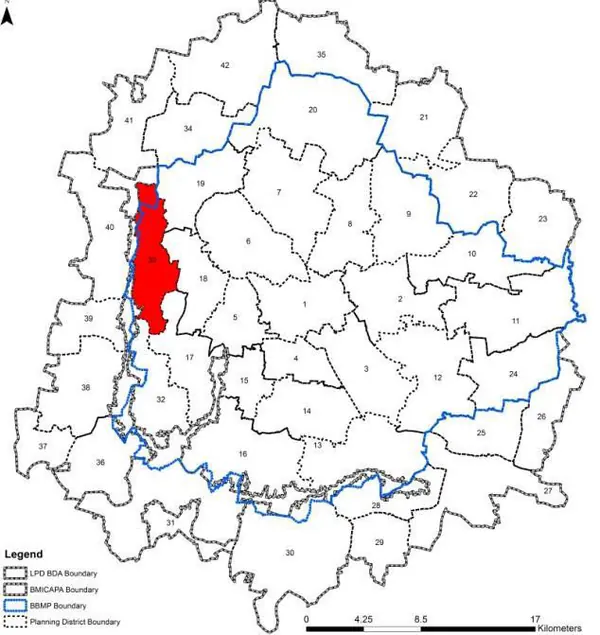
The Planning District 33, Herohalli is located at Western boundary of the BMA. PD is characterised predominantly by residential development abutting Peenya Industrial Area and has large tracts of vacant land. PD shares its boundary with BMICAPA. The Revised Master Plan 2031 proposes densification of the residential areas in a planned manner along with transit integration and infrastructure upgradation and planning for parks and open spaces.
1. The Herohalli PD comprises of 3 BBMP wards-Herohalli (72), Dodda Bidarakallu (40), Hegganahalli (71), of Dasanapura Zone and three villages (in parts & full) namely Thirumalapura, Chikkabidarakalu and Srikantapura falling between BBMP and BMICAPA boundary.
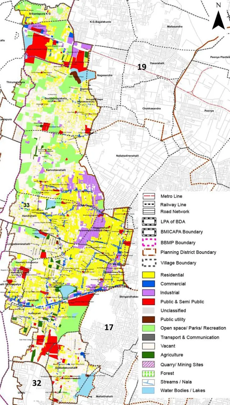
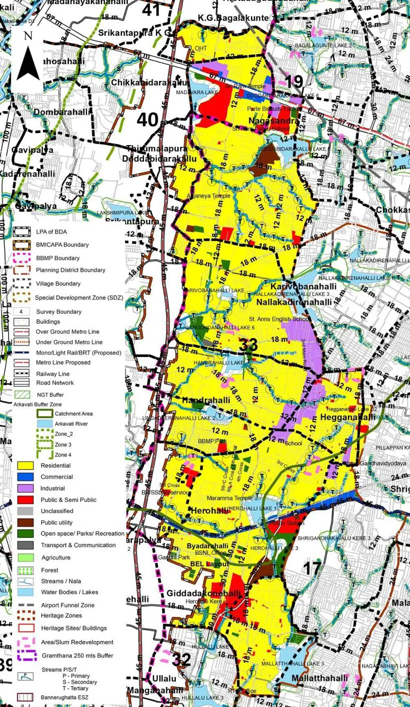
The Existing Land Use Map and Proposed Land Use Map for this PD are in the Planning District Report (PDF). Open the document and go to this PD’s section; use the List of Figures to find “PD 33 Existing Land Use Map” and “PD 33 Proposed Land Use Map”.
| Land use Category | Area (in Ha) | Percentage to Total Area (%) |
|---|---|---|
| Residential | 517.34 | 22.29 |
| Commercial | 61.27 | 2.64 |
| Industrial | 122.91 | 5.30 |
| Quarry/ Mining Sites | 0.00 | 0.00 |
| Public & Semi Public | 110.94 | 4.78 |
| Unclassified | 0.00 | 0.00 |
| Public Utility | 0.00 | 0.00 |
| Parks & Open Spaces | 20.19 | 0.87 |
| Transport & Communication | 217.51 | 9.37 |
| Vacant | 827.66 | 35.66 |
| Agriculture | 358.83 | 15.46 |
| Forest | 0.00 | 0.00 |
| Streams | 0.00 | 0.00 |
| Water Bodies | 71.49 | 3.08 |
| NGT Buffer | 0.00 | 0.00 |
| Other | 6.03 | 0.26 |
| Total | 2321.00 | 100.00 |
| Land use Category | Area (in Ha) | Percentage To Total Developable Area (%) |
|---|---|---|
| Residential | 1390.84 | 59.92 |
| Commercial | 24.37 | 1.05 |
| Industrial | 86.11 | 3.71 |
| Quarry/ Mining Sites | 0.00 | 0.00 |
| Public & Semi Public | 120.00 | 5.17 |
| Unclassified | 0.00 | 0.00 |
| Public Utility | 26.69 | 1.15 |
| Parks & Open Spaces | 48.28 | 2.08 |
| Transport & Communication | 296.49 | 12.77 |
| Vacant | 0.00 | 0.00 |
| Agriculture | 0.00 | 0.00 |
| Forest | 0.00 | 0.00 |
| Streams | 0.00 | 0.00 |
| Water Bodies | 68.93 | 2.97 |
| NGT Buffer | 253.79 | 10.93 |
| Other | 5.34 | 0.23 |
| Total Developable Area | 2320.84 | , |
Total PD Area 2321.00 Ha. Source: Revised Master Plan 2031 (Draft) Volume-4.
Road Development Plan, Public Transport System, Multimodal Interchange Stations, Parks and Open Spaces, Protection and Rejuvenation of Lakes and Streams, Area Redevelopment, Heritage Area Protection and Conservation, Physical Infrastructure, Disaster Mitigation.