Demography
Population (2011)
47,043
Census 2011
Area
2680.2 Ha
26.80 sq.km
Gross Density
18 PPH
Persons per Hectare
Wards/Villages
18
Outside BBMP
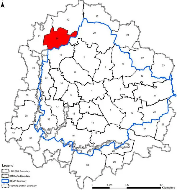
North-west BMA, abutting BBMP. 18 villages, 4 GPs. 111.1% decadal growth. Hessaraghatta Road, Bengaluru-Mumbai Railway (Chikkabanavara, Soladevanahalli stations). 21 lakes to Arakavati. 34 schools; Acharya, Sri Krishna Institute. One Govt PHC Chikkabanavara. No fire station, burial/crematorium, SWM, substation.
Villages in PD: 18 Gram Panchayats: Chikkabanawara, Vaderahalli, Somashettahalli and Kasaghattapura The Chikkabanawara Planning District (PD No. 34) is located in the north- western side in abutting to BBMP Boundary. It is characterised by haphazard developments along Hessarghatta Road and areas abutting to BBMP, and agricultural landscape. The Revised Master Plan 2031 proposes to promote planned growth while maintaining the present conurbation, integrate public transport systems, and environment protection.
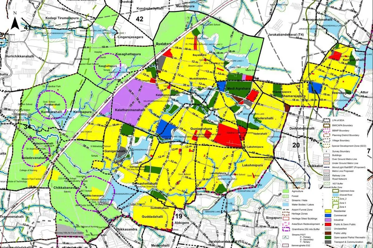
The Existing Land Use Map and Proposed Land Use Map for this PD are in the Planning District Report (PDF). Open the document and go to this PD’s section; use the List of Figures to find “PD 34 Existing Land Use Map” and “PD 34 Proposed Land Use Map”.
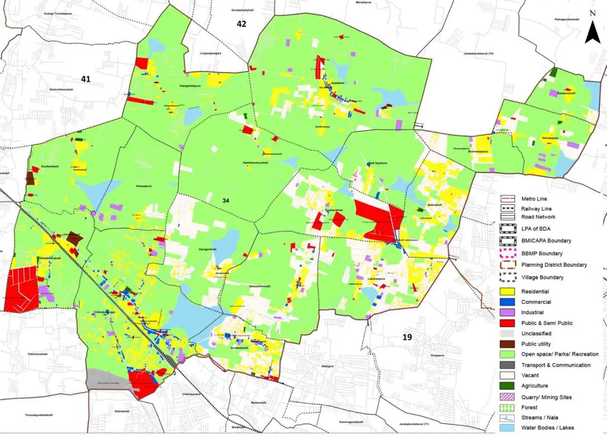
| Land use Category | Area (in Ha) | Percentage to Total Area (%) |
|---|---|---|
| Residential | 225.13 | 8.40 |
| Commercial | 18.23 | 0.68 |
| Industrial | 32.16 | 1.20 |
| Quarry/ Mining Sites | 0.00 | 0.00 |
| Public & Semi Public | 90.86 | 3.39 |
| Unclassified | 15.28 | 0.57 |
| Public Utility | 0.00 | 0.00 |
| Parks & Open Spaces | 4.56 | 0.17 |
| Transport & Communication | 122.75 | 4.58 |
| Vacant | 568.20 | 21.20 |
| Agriculture | 1468.73 | 54.80 |
| Forest | 0.00 | 0.00 |
| Streams | 0.00 | 0.00 |
| Water Bodies | 121.14 | 4.52 |
| NGT Buffer | 0.00 | 0.00 |
| Other | 6.97 | 0.26 |
| Total | 2680.17 | 100.00 |
| Land use Category | Area (in Ha) | Percentage To Total Developable Area (%) |
|---|---|---|
| Residential | 1450.80 | 54.13 |
| Commercial | 41.81 | 1.56 |
| Industrial | 142.32 | 5.31 |
| Quarry/ Mining Sites | 0.00 | 0.00 |
| Public & Semi Public | 98.63 | 3.68 |
| Unclassified | 0.00 | 0.00 |
| Public Utility | 0.00 | 0.00 |
| Parks & Open Spaces | 170.99 | 6.38 |
| Transport & Communication | 349.03 | 13.02 |
| Vacant | 0.00 | 0.00 |
| Agriculture | 0.00 | 0.00 |
| Forest | 0.00 | 0.00 |
| Streams | 0.00 | 0.00 |
| Water Bodies | 82.28 | 3.07 |
| NGT Buffer | 328.59 | 12.26 |
| Other | 6.97 | 0.26 |
| Total Developable Area | 2671.42 | , |
Total PD Area 2680.17 Ha. Source: Revised Master Plan 2031 (Draft) Volume-4.
Road Development Plan, Public Transport System, Multimodal Interchange Stations, Parks and Open Spaces, Protection and Rejuvenation of Lakes and Streams, Area Redevelopment, Heritage Area Protection and Conservation, Physical Infrastructure, Disaster Mitigation.