Demography
Population (2011)
18,373
Census 2011
Area
3253.0 Ha
32.53 sq.km
Gross Density
6 PPH
Persons per Hectare
Wards/Villages
12
Outside BBMP
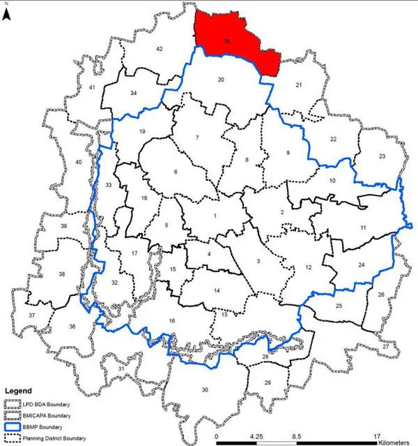
North BMA along Bellary Road, boundary with BIAAPA. 12 villages, 4 GPs. 55.6% decadal growth. Yelahanka Air Force Station, Sir M Visvesvaraya IT, Krishnadevaraya Dental, NITTE, Padukone-Dravid Sports. Bettahalasuru quarry, 11 lakes, railway to Devanahalli (Bettahalasuru station). 15 schools; no large hospital.
SPECIAL DEVELOPMENT ZONE Villages in PD: 12 Gram Panchayats: Bettahalasuru, Gantiganahalli, Sonnappanahalli and Hunasamaranahalli. Bettahalasuru – Hunasamaranahalli Planning District (PD. No. 35) is located in the northern part of BMA along Bellary Road and shares with boundary with LPA of BIAAPA. It is witnessing heightened growth along Bellary Road. The PD is characteristed by predominant agriculture use, large quarry area, developments along Bellary Road and Yelahanka Airforce Station. The Revised Master Plan 2031 proposes to develop the PD as a Special Development Zone that would promote high density planned employment centres and residential developments, while protecting environmentally sensitive areas.
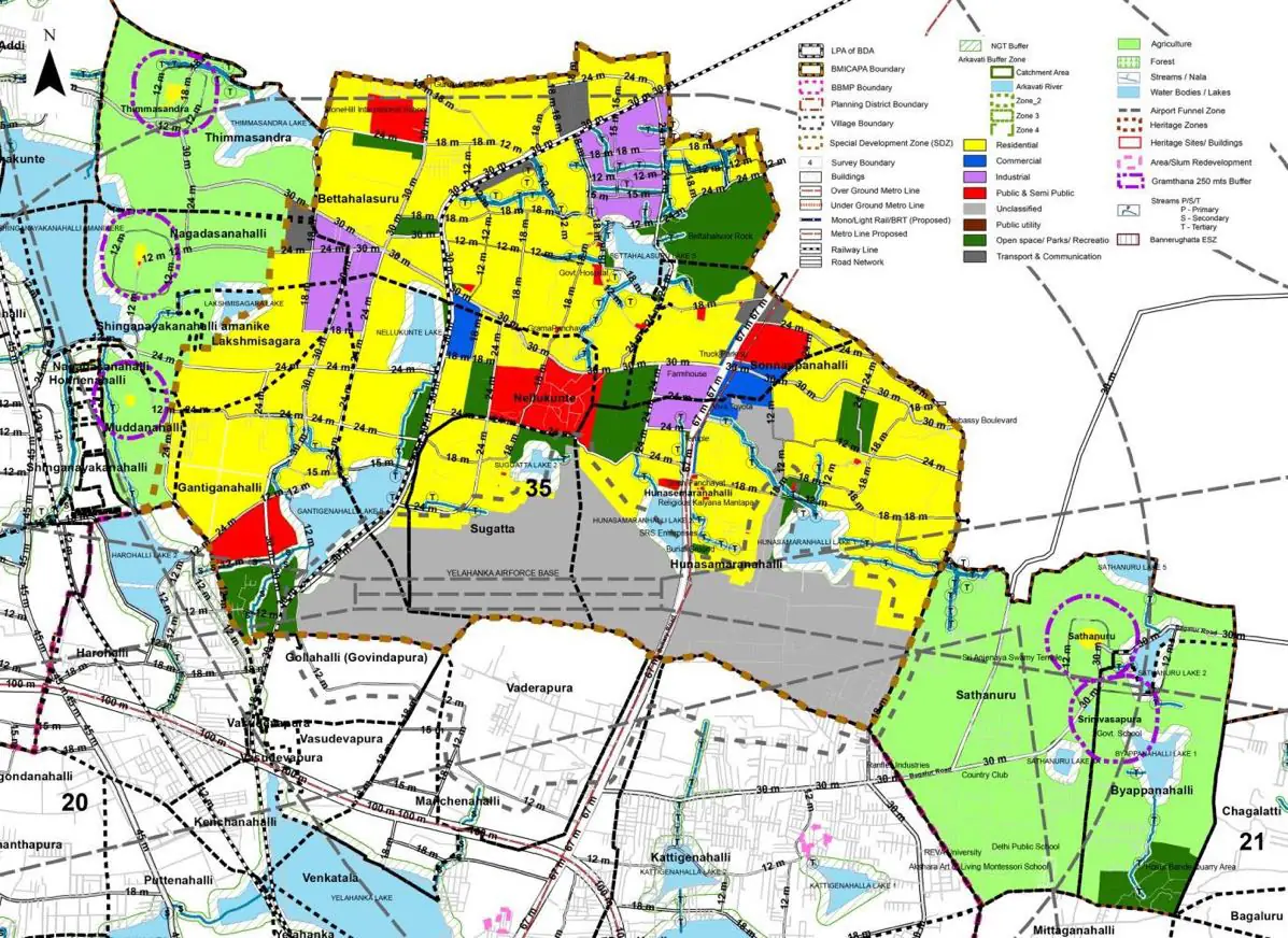
The Existing Land Use Map and Proposed Land Use Map for this PD are in the Planning District Report (PDF). Open the document and go to this PD’s section; use the List of Figures to find “PD 35 Existing Land Use Map” and “PD 35 Proposed Land Use Map”.
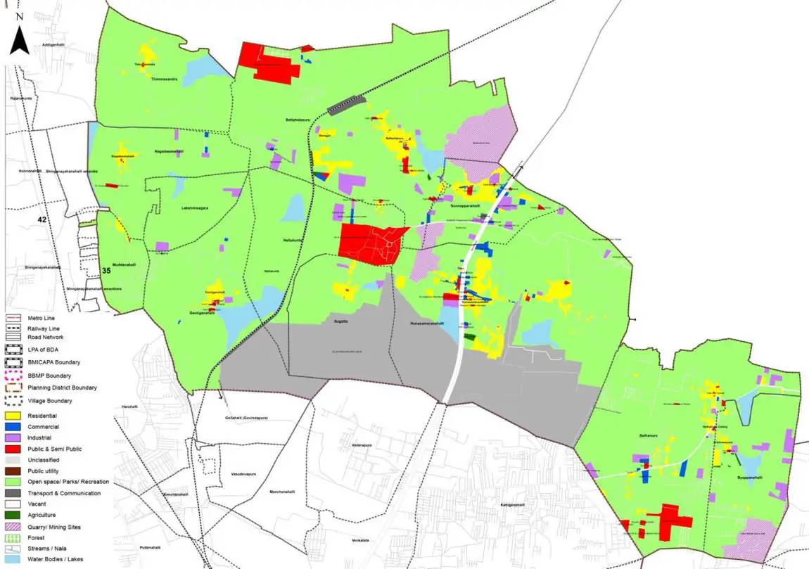
| Land use Category | Area (in Ha) | Percentage to Total Area (%) |
|---|---|---|
| Residential | 117.43 | 3.61 |
| Commercial | 14.96 | 0.46 |
| Industrial | 53.99 | 1.66 |
| Quarry/ Mining Sites | 100.84 | 3.10 |
| Public & Semi Public | 84.25 | 2.59 |
| Unclassified | 427.44 | 13.14 |
| Public Utility | 0.00 | 0.00 |
| Parks & Open Spaces | 2.60 | 0.08 |
| Transport & Communication | 118.41 | 3.64 |
| Vacant | 521.78 | 16.04 |
| Agriculture | 1710.43 | 52.58 |
| Forest | 0.00 | 0.00 |
| Streams | 0.00 | 0.00 |
| Water Bodies | 97.92 | 3.01 |
| NGT Buffer | 0.00 | 0.00 |
| Other | 2.28 | 0.07 |
| Total | 3253.00 | 100.00 |
| Land use Category | Area (in Ha) | Percentage To Total Developable Area (%) |
|---|---|---|
| Residential | 1353.58 | 41.61 |
| Commercial | 35.78 | 1.10 |
| Industrial | 131.42 | 4.04 |
| Quarry/ Mining Sites | 0.00 | 0.00 |
| Public & Semi Public | 133.90 | 4.12 |
| Unclassified | 625.63 | 19.23 |
| Public Utility | 0.00 | 0.00 |
| Parks & Open Spaces | 221.20 | 6.80 |
| Transport & Communication | 364.71 | 11.21 |
| Vacant | 0.00 | 0.00 |
| Agriculture | 0.00 | 0.00 |
| Forest | 0.00 | 0.00 |
| Streams | 0.00 | 0.00 |
| Water Bodies | 94.34 | 2.90 |
| NGT Buffer | 289.89 | 8.91 |
| Other | 2.93 | 0.09 |
| Total Developable Area | 3253.38 | , |
Total PD Area 3253.00 Ha. Source: Revised Master Plan 2031 (Draft) Volume-4.
Road Development Plan, Public Transport System, Multimodal Interchange Stations, Parks and Open Spaces, Protection and Rejuvenation of Lakes and Streams, Area Redevelopment, Heritage Area Protection and Conservation, Physical Infrastructure, Disaster Mitigation.