Demography
Population (2011)
32,239
Census 2011
Area
2685.8 Ha
26.86 sq.km
Gross Density
12 PPH
Persons per Hectare
Wards/Villages
12
Outside BBMP
South-west BMA along Mysuru Road, boundary with BMICAPA. 12 villages, 3 GPs. 106.35% decadal growth. Kumbalagodu Industrial Area, Christ University, Don Bosco IT, RRCE, Medical College, Apollo Naturopathy, SDM Ayurvedic, BGS. 32 schools. Vrishabhavathi River. Entire PD in Vrishabhavathi watershed.
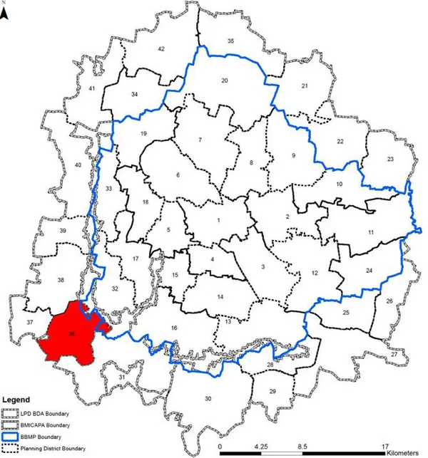
ZONE Villages in PD: 12 Gram Panchayats: Kumbalagodu, Ramohalli and Kumbalagodu Gollahalli Kumbalagodu Planning District (PD No. 36) is located in the south-western periphery within BMP along Mysuru road and it shares its boundary with BMICAPA. It is characterised by the presence of large tracts Kumbalagodu Industrial Area, several education institutions, scattered, plotted as well as high rise residential development and Vrushabhavati River. The Revised Master Plan 2031 proposes development of education oriented Special Development Zone in the planning district supported by public transport and recreational facilities. A. EXISTING SITUTATION
1. Kumbalagodu Planning District admeasures 2685.76 Ha (26.85 sqkm) with 12 villages from three different Gram Panchayats, namely – Kumbalagodu GP, Ramohalli GP and Kumbalagodu Gollahalli GP. Village within PD are Chellaghatta, Doddabele, Venkatapura, Kambipura, Kumbalagodu, Kanaminake, Thagachikuppi, Kumbalagodu, Gollahalli, Gudamava, Devageri, Gangasandra, and Vasanthanahalli. The Mysuru Road and Bengaluru - Mysuru Railway line run parallel to each other and run north south in the PD.
The Existing Land Use Map and Proposed Land Use Map for this PD are in the Planning District Report (PDF). Open the document and go to this PD’s section; use the List of Figures to find “PD 36 Existing Land Use Map” and “PD 36 Proposed Land Use Map”.
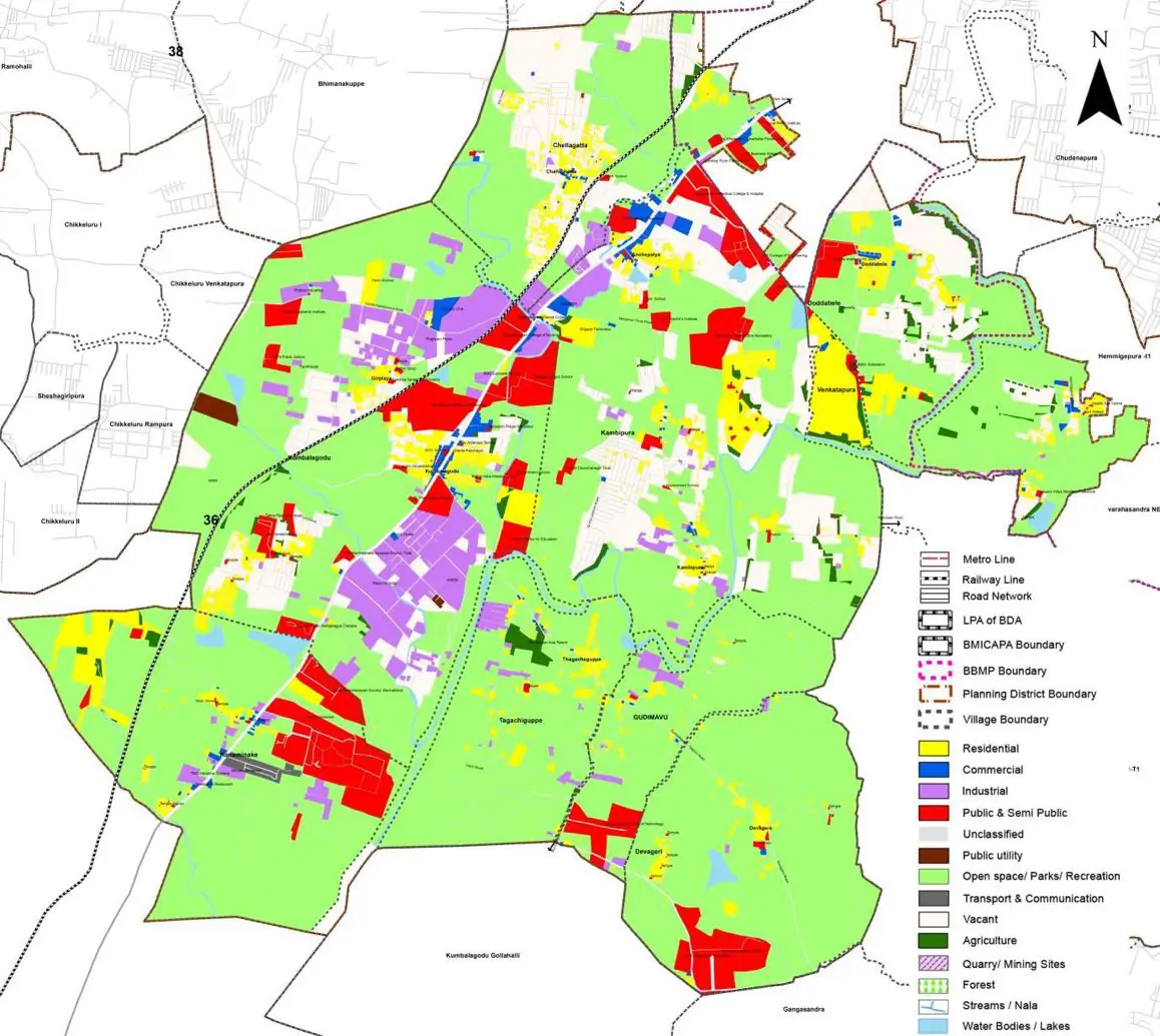
| Land use Category | Area (in Ha) | Percentage to Total Area (%) |
|---|---|---|
| Residential | 181.02 | 6.74 |
| Commercial | 21.22 | 0.79 |
| Industrial | 134.56 | 5.01 |
| Quarry/ Mining Sites | 0.00 | 0.00 |
| Public & Semi Public | 175.11 | 6.52 |
| Unclassified | 0.00 | 0.00 |
| Public Utility | 4.57 | 0.17 |
| Parks & Open Spaces | 28.47 | 1.06 |
| Transport & Communication | 103.13 | 3.84 |
| Vacant | 395.68 | 14.73 |
| Agriculture | 1587.92 | 59.12 |
| Forest | 0.00 | 0.00 |
| Streams | 0.00 | 0.00 |
| Water Bodies | 18.80 | 0.70 |
| NGT Buffer | 0.00 | 0.00 |
| Other | 34.64 | 1.29 |
| Total | 2685.76 | 100.00 |
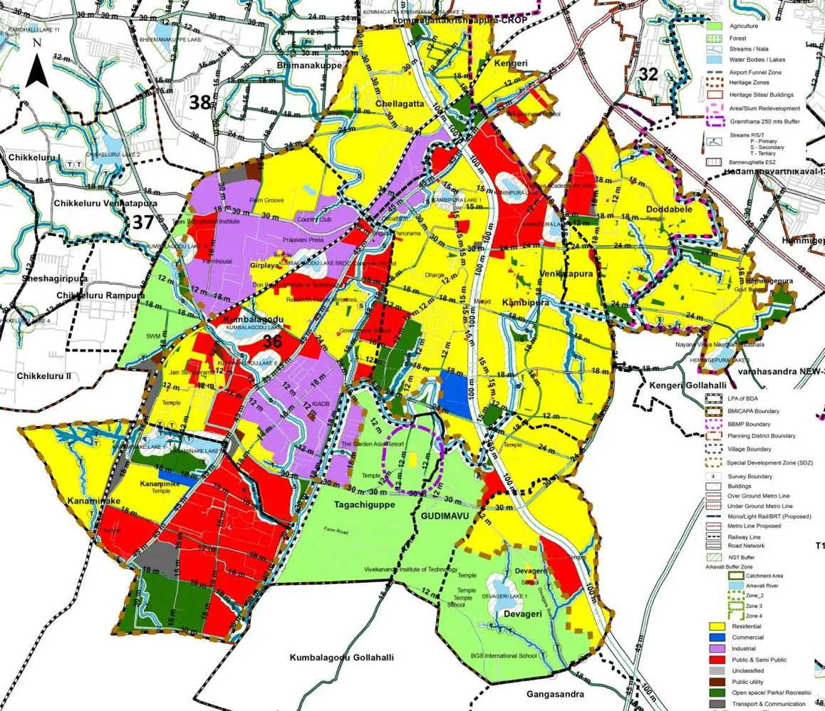
| Land use Category | Area (in Ha) | Percentage To Total Developable Area (%) |
|---|---|---|
| Residential | 1114.59 | 41.50 |
| Commercial | 23.10 | 0.86 |
| Industrial | 244.14 | 9.09 |
| Quarry/ Mining Sites | 0.00 | 0.00 |
| Public & Semi Public | 380.57 | 14.17 |
| Unclassified | 0.00 | 0.00 |
| Public Utility | 6.98 | 0.26 |
| Parks & Open Spaces | 125.69 | 4.68 |
| Transport & Communication | 391.12 | 14.56 |
| Vacant | 0.00 | 0.00 |
| Agriculture | 0.00 | 0.00 |
| Forest | 0.00 | 0.00 |
| Streams | 0.00 | 0.00 |
| Water Bodies | 16.65 | 0.62 |
| NGT Buffer | 352.17 | 13.11 |
| Other | 30.08 | 1.12 |
| Total Developable Area | 2685.09 | , |
Total PD Area 2685.76 Ha. Source: Revised Master Plan 2031 (Draft) Volume-4.
Road Development Plan, Public Transport System, Multimodal Interchange Stations, Parks and Open Spaces, Protection and Rejuvenation of Lakes and Streams, Area Redevelopment, Heritage Area Protection and Conservation, Physical Infrastructure, Disaster Mitigation.